Difference between revisions of "Huntingdonshire"
(Created page with '{{Infobox county |name=Huntingdonshire |map image=HuntingdonshireBrit5.PNG |flag=FlagOfHuntingdonshire.PNG |picture=St Ives The Quay.jpg |picture caption=St Ives |area=359 square…') |
|||
| (22 intermediate revisions by 5 users not shown) | |||
| Line 1: | Line 1: | ||
{{Infobox county | {{Infobox county | ||
|name=Huntingdonshire | |name=Huntingdonshire | ||
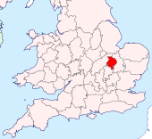
| − | |map image= | + | |map image=Huntingdonshire Brit Isles Sect 5.svg |
| − | |flag= | + | |flag={{database|Huntingdonshire|flag}} |
| − | |picture=St Ives The Quay.jpg | + | |picture=St Ives The Quay 2.jpg |
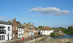
|picture caption=St Ives | |picture caption=St Ives | ||
| − | |||
|county town=[[Huntingdon]] | |county town=[[Huntingdon]] | ||
|biggest town=[[St Neots]] | |biggest town=[[St Neots]] | ||
| + | |flower=water violet | ||
}} | }} | ||
| + | The '''County of Huntingdon''' (abbreviated '''Hunts''') is a [[Counties of the United Kingdom|shire]] between the [[Midlands]] and [[East Anglia]]. It is one of the smaller counties in [[Great Britain]]; in [[England]] only [[Rutland]] and [[Middlesex]] are smaller. | ||
| − | + | The county is roughly a rhombus shape, lying between bordering on [[Northamptonshire]] to the north and north-west, [[Bedfordshire]] to the south-west and [[Cambridgeshire]] to the east. The [[county town]], [[Huntingdon]], lies at the centre of the county. | |
| − | {{ | + | ==Geography== |
| + | |||
| + | Large areas of the county are extremely low-lying and [[Holme Fen]] is notable for being the United Kingdom's lowest point, at 9 feet below sea level. The county's highest point is Boring Field, near [[Covington]] at 263 feet above sea level; the lowest highest point of all the counties. | ||
| + | |||
| + | The [[Great Ouse]] cuts across the county, and three of the county's four towns stand on its banks. The Great Ouse enters Huntingdonshire at [[St Neots]], flowing northward then eastward to [[Huntingdon]] and on to [[St Ives, Huntingdonshire|St Ives]] before leaving the county at [[Earith]]. At Earith the Ouse is briefly tidal, taking its tide from the Bedford Rivers. | ||
| + | |||
| + | The A1, on the route of the Great North Road, passes through Huntingdonshire close to its southernmost to its northernmost points and, the A14 crossing from east to west, Huntingdonshire has become a major transport hub, with development close to the major routes. | ||
| + | |||
| + | Southern Huntingdonshire has its main townscapes by the main roads, but away from those routes it is a rich agricultural landscape characterised by farming and picturesque villages. | ||
| + | |||
| + | North of Huntingdon lies the county's share of the [[Great Fen]]. Much of the land here is below sea level and the landscape in the northeast in particular presents a vast, flat appearance. There are many small, pretty hamlets and villages scattered across the fen, the only town of any size south of the Peterborough suburbs being [[Ramsey, Huntingdonshire|Ramsey]]. | ||
| + | |||
| + | ==Sports== | ||
| + | |||
| + | Huntingdonshire County Cricket Club has its main ground in [[Godmanchester]]. It is the only county cricket club to be classed as neither a first class county nor a minor county. | ||
| + | |||
| + | Huntingdonshire claims to be the birthplace of bandy, a form of ice-hockey, now an IOC accepted sport.<ref>[http://www.internationalbandy.com/viewNavMenu.do?menuID=4 http://www.internationalbandy.com/viewNavMenu.do?menuID=4]</ref> According to documents from 1813, Bury Fen Bandy Club was undefeated for 100 years. A member of the club, Charles Tebbutt, wrote the first official rules down in 1882 and was instrumental in spreading the sport to many countries.<ref>http://www.bbc.co.uk/cambridgeshire/content/articles/2006/02/15/bandy_sport_feature.shtml</ref> | ||
| + | |||
| + | ==Hundres== | ||
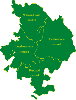
| + | [[File:Huntingdonshire Hundreds.svg|thumb|250px|The hundreds of Huntingdonshire]] | ||
| + | {{main|Hundreds of Huntingdonshire}} | ||
| + | The county is divided into four hundreds plus the borough of [[Huntingdon]] in the centre, locally in Hurstingstone hundred. | ||
| + | |||
| + | The hundreds are:: | ||
| + | *[[Norman Cross Hundred]] | ||
| + | *[[Leightonstone Hundred]] | ||
| + | *[[Hurstingstone Hundred]] | ||
| + | *[[Toseland Hundred]] | ||
| + | |||
| + | ==Towns and villages== | ||
| + | |||
| + | ===Major towns=== | ||
| + | * [[Huntingdon]] | ||
| + | * [[Ramsey, Huntingdonshire|Ramsey]] | ||
| + | * [[St Ives, Huntingdonshire|St Ives]] | ||
| + | * [[St Neots]] | ||
| + | |||
| + | Falling partly within Huntingdonshire: | ||
| + | |||
| + | * [[Peterborough]] suburbs including [[Fletton]] and [[The Ortons]] | ||
| + | |||
| + | ===Villages=== | ||
| + | <small> | ||
| + | * [[Abbots Ripton]], [[Abbotsley]], [[Alconbury]], [[Alconbury Weston]], [[Alwalton]] | ||
| + | * [[Barham, Huntingdonshire|Barham]], [[Bury, Huntingdonshire|Bury]], [[Bluntisham]], [[Brampton, Huntingdonshire|Brampton]], [[Brington, Huntingdonshire|Brington]], [[Broughton, Huntingdonshire|Broughton]], [[Buckden, Huntingdonshire|Buckden]], [[Buckworth]], [[Bythorn]] | ||
| + | * [[Catworth]], [[Chesterton, Huntingdonshire|Chesterton]], [[Colne, Huntingdonshire|Colne]], [[Conington, Huntingdonshire|Conington]], [[Coppingford]], [[Covington]] | ||
| + | * [[Denton and Caldecote]], [[Diddington]] | ||
| + | * [[Earith]], [[Easton, Huntingdonshire|Easton]], [[Ellington, Huntingdonshire|Ellington]], [[Elton, Huntingdonshire|Elton]], [[Eynesbury]] | ||
| + | * [[Farcet]], [[Fenstanton]], [[Folksworth & Washingley]] | ||
| + | * [[Glatton]], [[Godmanchester]], [[Grafham, Huntingdonshire|Grafham]], [[Great Gransden]], [[Great Gidding|Great, Little and Steeple Gidding]], [[Great Paxton]], [[Great Staughton]] | ||
| + | * [[Haddon]], [[Hail Weston]], [[Hamerton]], [[Hartford, Huntingdonshire|Hartford]], [[Hemingford Abbots]], [[Hemingford Grey]] [[Hilton, Huntingdonshire|Hilton]], [[Holme, Huntingdonshire|Holme]], [[Holywell, Huntingdonshire|Holywell]], [[Houghton, Huntingdonshire|Houghton]] | ||
| + | * [[Keyston]], [[Kimbolton]], [[Kings Ripton]] | ||
| + | * [[Leighton Bromswold]], [[Little Paxton]] | ||
| + | * [[Molesworth]], [[Morborne]] | ||
| + | * [[Needingworth]] | ||
| + | * [[The Offords]], [[Oldhurst]], [[Old Weston]] | ||
| + | * [[Perry, Huntingdonshire|Perry]], [[Pidley]] | ||
| + | * [[Ramsey St Mary's]] , [[The Raveleys]] | ||
| + | * [[Sawtry]], [[Spaldwick]], [[Somersham]], [[Southhoe and Midloe]], [[Stanground]], [[Stibbington]], [[Stilton]], [[Stow Longa]], [[The Stukeleys]] | ||
| + | * [[Tetworth]], [[Toseland]] | ||
| + | * [[Upton, Huntingdonshire|Upton]], [[Upwood]] | ||
| + | * [[Wansford, Huntingdonshire|Wansford]], [[Warboys]], [[Waresley]], [[Water Newton]], [[Winwick, Huntingdonshire|Winwick]], [[Wistow, Huntingdonshire|Wistow]], [[Woodhurst]], [[Woodwalton]], [[Woolley]], [[Wyton, Huntingdonshire|Wyton]] | ||
| + | * [[Yaxley, Huntingdonshire|Yaxley]], [[Yelling]] | ||
| + | </small> | ||
| + | |||
| + | == Places of interest == | ||
| + | {{UKPlacesKey}} | ||
| + | |||
| + | *[[Brampton Wood]] | ||
| + | *Bridge Chapel, [[St Ives, Huntingdonshire|St Ives]] | ||
| + | *{{i-House}} [[Buckden Towers]] | ||
| + | *Castle Hill, [[Huntingdon]] | ||
| + | *Oliver Cromwell's birthplace, [[Huntingdon]] | ||
| + | *{{i-House}} [[Elton Hall]] | ||
| + | *[[Gamsey Wood]] Nature Reserve | ||
| + | *[[Grafham Water]] Nature Reserve | ||
| + | *[[Great Gransden]] Post Mill | ||
| + | *River [[Great Ouse]] | ||
| + | *{{i-House}} [[Hinchingbrooke House]] | ||
| + | *{{i-NTE}} [[Houghton Mill]] | ||
| + | *[[Huntingdon]] mediaeval bridge | ||
| + | *{{i-House}} [[Kimbolton Castle]] | ||
| + | *{{i-HR}} [[Nene Valley Railway]] | ||
| + | *[[Ouse Valley Way]] | ||
| + | *[[Paxton]] Pits Nature Reserve | ||
| + | *[[Portholme]] meadow, between Huntingdon and [[Godmanchester]] | ||
| + | *{{i-NTE}} [[Ramsey Abbey Gatehouse]] | ||
| + | *[[St Neots]] Riverside | ||
| + | |||
| + | ==Famous people of Huntingdonshire== | ||
| + | |||
| + | * '''Oliver Cromwell''' (1599-1658), Lord Protector of England, Scotland and Ireland 1653-58 | ||
| + | * '''Peter Foxhall''' (1941- ), Australian clergyman, evangelist and author | ||
| + | * '''John Major''' (1943- ), Prime Minister 1990-1997 | ||
| + | * '''Samuel Pepys''' (1633-1703), Second Secretary to the Admiralty and diarist | ||
| + | * '''Henry Royce''' (1863-1933) founder of Rolls Royce | ||
| + | |||
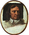
| + | [[File:Cooper, Oliver Cromwell.jpg|right|thumb|100px|Oliver Cromwell]] | ||
| + | |||
| + | ==Notes== | ||
| + | {{reflist}} | ||
| + | |||
| + | ==Outside links== | ||
| + | *[http://www.huntingdonshire.org.uk The Huntingdonshire Society] | ||
{{British county}} | {{British county}} | ||
Latest revision as of 11:18, 8 February 2020
| Huntingdonshire United Kingdom | |
 St Ives | |
|---|---|

| |
| Flag | |
| Labore omnia florent (By labour everything prospers) | |

| |
| [Interactive map] | |
| Area: | 366 square miles |
| Population: | 211,776 |
| County town: | Huntingdon |
| Biggest town: | St Neots |
| County flower: | Water-violet [1] |
The County of Huntingdon (abbreviated Hunts) is a shire between the Midlands and East Anglia. It is one of the smaller counties in Great Britain; in England only Rutland and Middlesex are smaller.
The county is roughly a rhombus shape, lying between bordering on Northamptonshire to the north and north-west, Bedfordshire to the south-west and Cambridgeshire to the east. The county town, Huntingdon, lies at the centre of the county.
Contents
Geography
Large areas of the county are extremely low-lying and Holme Fen is notable for being the United Kingdom's lowest point, at 9 feet below sea level. The county's highest point is Boring Field, near Covington at 263 feet above sea level; the lowest highest point of all the counties.
The Great Ouse cuts across the county, and three of the county's four towns stand on its banks. The Great Ouse enters Huntingdonshire at St Neots, flowing northward then eastward to Huntingdon and on to St Ives before leaving the county at Earith. At Earith the Ouse is briefly tidal, taking its tide from the Bedford Rivers.
The A1, on the route of the Great North Road, passes through Huntingdonshire close to its southernmost to its northernmost points and, the A14 crossing from east to west, Huntingdonshire has become a major transport hub, with development close to the major routes.
Southern Huntingdonshire has its main townscapes by the main roads, but away from those routes it is a rich agricultural landscape characterised by farming and picturesque villages.
North of Huntingdon lies the county's share of the Great Fen. Much of the land here is below sea level and the landscape in the northeast in particular presents a vast, flat appearance. There are many small, pretty hamlets and villages scattered across the fen, the only town of any size south of the Peterborough suburbs being Ramsey.
Sports
Huntingdonshire County Cricket Club has its main ground in Godmanchester. It is the only county cricket club to be classed as neither a first class county nor a minor county.
Huntingdonshire claims to be the birthplace of bandy, a form of ice-hockey, now an IOC accepted sport.[1] According to documents from 1813, Bury Fen Bandy Club was undefeated for 100 years. A member of the club, Charles Tebbutt, wrote the first official rules down in 1882 and was instrumental in spreading the sport to many countries.[2]
Hundres
- Main article: Hundreds of Huntingdonshire
The county is divided into four hundreds plus the borough of Huntingdon in the centre, locally in Hurstingstone hundred.
The hundreds are::
Towns and villages
Major towns
Falling partly within Huntingdonshire:
- Peterborough suburbs including Fletton and The Ortons
Villages
- Abbots Ripton, Abbotsley, Alconbury, Alconbury Weston, Alwalton
- Barham, Bury, Bluntisham, Brampton, Brington, Broughton, Buckden, Buckworth, Bythorn
- Catworth, Chesterton, Colne, Conington, Coppingford, Covington
- Denton and Caldecote, Diddington
- Earith, Easton, Ellington, Elton, Eynesbury
- Farcet, Fenstanton, Folksworth & Washingley
- Glatton, Godmanchester, Grafham, Great Gransden, Great, Little and Steeple Gidding, Great Paxton, Great Staughton
- Haddon, Hail Weston, Hamerton, Hartford, Hemingford Abbots, Hemingford Grey Hilton, Holme, Holywell, Houghton
- Keyston, Kimbolton, Kings Ripton
- Leighton Bromswold, Little Paxton
- Molesworth, Morborne
- Needingworth
- The Offords, Oldhurst, Old Weston
- Perry, Pidley
- Ramsey St Mary's , The Raveleys
- Sawtry, Spaldwick, Somersham, Southhoe and Midloe, Stanground, Stibbington, Stilton, Stow Longa, The Stukeleys
- Tetworth, Toseland
- Upton, Upwood
- Wansford, Warboys, Waresley, Water Newton, Winwick, Wistow, Woodhurst, Woodwalton, Woolley, Wyton
- Yaxley, Yelling
Places of interest
| Key | |
| |
Cathedral/Abbey/Priory |
| |
Accessible open space |
| |
Amusement/Theme Park |
| |
Castle |
| |
Country Park |
| |
English Heritage |
| |
Forestry Commission |
| |
Heritage railway |
| |
Historic House |
| |
Museum (free/not free) |
| |
National Trust |
| |
Zoo |
- Brampton Wood
- Bridge Chapel, St Ives
 Buckden Towers
- Castle Hill, Huntingdon
- Oliver Cromwell's birthplace, Huntingdon
 Elton Hall
- Gamsey Wood Nature Reserve
- Grafham Water Nature Reserve
- Great Gransden Post Mill
- River Great Ouse
 Hinchingbrooke House
 Houghton Mill
- Huntingdon mediaeval bridge
 Kimbolton Castle
 Nene Valley Railway
 - Ouse Valley Way
- Paxton Pits Nature Reserve
- Portholme meadow, between Huntingdon and Godmanchester
 Ramsey Abbey Gatehouse
- St Neots Riverside
Famous people of Huntingdonshire
- Oliver Cromwell (1599-1658), Lord Protector of England, Scotland and Ireland 1653-58
- Peter Foxhall (1941- ), Australian clergyman, evangelist and author
- John Major (1943- ), Prime Minister 1990-1997
- Samuel Pepys (1633-1703), Second Secretary to the Admiralty and diarist
- Henry Royce (1863-1933) founder of Rolls Royce
Notes
Outside links
| Counties of the United Kingdom |
|---|
|
Aberdeen • Anglesey • Angus • Antrim • Argyll • Armagh • Ayr • Banff • Bedford • Berks • Berwick • Brecknock • Buckingham • Bute • Caernarfon • Caithness • Cambridge • Cardigan • Carmarthen • Chester • Clackmannan • Cornwall • Cromarty • Cumberland • Denbigh • Derby • Devon • Dorset • Down • Dumfries • Dunbarton • Durham • East Lothian • Essex • Fermanagh • Fife • Flint • Glamorgan • Gloucester • Hants • Hereford • Hertford • Huntingdon • Inverness • Kent • Kincardine • Kinross • Kirkcudbright • Lanark • Lancaster • Leicester • Lincoln • Londonderry • Merioneth • Middlesex • Midlothian • Monmouth • Montgomery • Moray • Nairn • Norfolk • Northampton • Northumberland • Nottingham • Orkney • Oxford • Peebles • Pembroke • Perth • Radnor • Renfrew • Ross • Roxburgh • Rutland • Selkirk • Shetland • Salop • Somerset • Stafford • Stirling • Suffolk • Surrey • Sussex • Sutherland • Tyrone • Warwick • West Lothian • Westmorland • Wigtown • Wilts • Worcester • York |

