County Armagh
| County Armagh United Kingdom | |
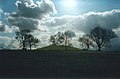
 View to Slieve Gullion | |
|---|---|

| |
| [Interactive map] | |
| Area: | 512 square miles |
| Population: | 178,598 |
| County seat: | Armagh |
| Biggest town: | Newry partly in Downshire |
| County flower: | Cowbane [1] |
The County of Armagh is a shire which lies in the south of Northern Ireland, on the border with the Republic of Ireland. Though landlocked, it has a coast on the south shore of Lough Neagh.
County Armagh is known as the "Orchard County" because the land is fertile and apple orchards abound.[1]
Armagh lies within the province of Ulster.
The climate of Armagh is considered to be one of the most genial in Ulster and all Ireland, and less rain is supposed to fall here than in any other county. In the high days of the Ulster linen industry, the farms of Armagh were busy with growing, weaving and bleaching as a cottage industry, far different from the gloom of the factories of Belfast.
Name of the shire
The name "Armagh" derives from the Gaelic Ard Macha, meaning "height (or high place) of Macha". Macha is figure from legend, described as one of the goddesses of Erse mythology and as the only High Queen of Ireland among the line of kings. Macha is mentioned in the Lebor Gabála Érenn ("Book of the Taking of Ireland"). The hill site of Emain Macha (now Navan Fort near the city of Armagh) is named after Macha also; legend says that she had it built to serve as the capital of the Kings of Ulster.
Lie of the land
From its highest point at Slieve Gullion (1,893 feet), in the south of the County, Armagh's land falls away from its rugged south with Carrigatuke, Lislea and Camlough mountains, to rolling drumlin country in the middle and west of the county and finally flatlands in the north where rolling flats and small hills reach sea level at Lough Neagh.
Slieve Gullion is formed of an extinct volcano and has a crater lake (and the highest burial cairn in Ireland). From the top, 9 counties can be seen.
The general landscape of Armaghshire is gently undulating and pleasantly diversified as far as the coastlands of Lough Neagh, where there is broad plain of low, marshy land. The hills rise in the south; no longer orchard country but rugged downland, something found also in the west, amongst a small range, the Few Mountains.
County Armagh's boundary with Louth is marked by the rugged Ring of Gullion rising in the south of the county whilst much of its boundary with Monaghan and Downshire goes unnoticed with seamless continuance of drumlins and small lakes. The River Blackwater marks the border with Tyrone and Lough Neagh otherwise marks out the County's northern boundary.
There are some uninhabited islands in the county's section of Lough Neagh, a lough with very few islands: Coney Island, Coney Island Flat, Croaghan Flat, Derrywarragh Island, Padian, Phil Roe's Flat and the Shallow Flat.
Rivers

The county is well watered. The main rivers, the Callan, the Tynan and the Tallwater, flow into the Blackwater, which, after forming the boundary between Armaghshire and Tyrone, empties itself into the south-western corner of Lough Neagh. The Tara and Newtown-Hamilton, the Creggan and the Fleury cross the border into County Louth and flow into the Bay of Dundalk. The Cam or Camlin joins the River Bann, which, crossing the north-western corner of the county, dissolves itself into Lough Neagh to the east of the Blackwater.
The Newry River marks the boundary with Downshire and its estuary grows into Carlingford Lough.
Geology
The flat shore of Lough Neagh in the north is due to the thick deposit of pale-coloured clays with lignites, which are probably of Pliocene age, and indicate a reduction of the area of the lake in still later times. Between this lowland and Armagh city, the early Cainozoic basalts form slightly higher ground, while on the west a strip of Trias appears, overlying Carboniferous Limestone. A rough conglomerate containing blocks of this latter rock forms the hills on which Armagh itself is built; this outlier is probably Permian. The Carboniferous Limestone beneath it and around it is red-brown instead of grey, and is famous for its richness in fish remains.
A hummocky irregular country spreads southward, where the Silurian axis is encountered, in continuation of the southern uplands of Scotland. Slates and fine-grained sandstones appear here freely through the glacial drift. In the south the granite core of this upland is revealed, and is quarried extensively about Bessbrook. It is penetrated by far younger intrusive masses at Slieve Gullion and Forkill. These rocks, which include some highly siliceous lavas, form part of the Eocene series that is so conspicuously displayed above Carlingford in County Louth. Lead-veins have been worked in various parts of the county from time to time.
History
Dark Ages

Ancient Armagh was the territory of the Ulaid before the fourth century AD. It was ruled by the Red Branch, whose capital was Emain Macha (or Navan Fort) near Armagh. The site was named after the Celtic goddess Macha, as was the later town of Armagh: Ard Macha, "the height of Macha". The Red Branch play an important role in the Ulster Cycle, as well as the Cattle Raid of Cooley. However, they were eventually driven out of the area by the Three Collas, who invaded in the 4th century and held power until the 12th. The Clan Colla ruled the area known as Airghialla or Oriel for these 800 years.
Through Armagh is "the Gap of the North", a pass between the hills giving access to Ulster from neighbouring lands, and this strategic position has been contested militarily for centuries, as remains in the landscape attest.
Armagh claims to have been the seat of St Patrick, for which reason the city has the cathedrals of two rival Archbishops of Armagh, of the Church of Ireland and of the Roman Catholic Church, both dedicated to St Patrick.
Clans and septs before Plantation
The chief Irish septs of the county were descendants of the Collas, the O'Hanlons and MacCanns, and the Ui Neill, the O'Neills of Fews. Armagh was divided into several baronies: Armagh was held by the O'Rogans, Lower Fews was held by O'Neill of the Fews, and Upper Fews were under governance of the O'Larkins, who were later displaced by the MacCanns. Oneilland East was the territory of the O'Garveys, who were also displaced by the MacCanns. Oneilland West, like Oneilland East, was once O'Neill territory, until it was then held by the MacCanns, who were Lords of Clanbrassil. Upper and Lower Orior were O'Hanlon territory. Tiranny was ruled by Ronaghan. Miscellaneous tracts of land were ruled by O'Kelaghan.
Shiring the land

Armagh, together with Louth, Monaghan and some smaller districts, formed part of a territory called Oriel, from the Gaelic Airgíalla (apparently unrelated to the similar name of Argyll). The county was formed as such only by Queen Elizabeth I in 1586, and called Armagh after the city by Sir John Perrott.
Though a shire was laid down, the land was unquiet in the Elizabethan days and Armagh's strategic position drew it into the warfare, which has left a legacy in the landscape. In the pass of Moyry, the entry into the county from the south, stands Moyry Castle, now a ruin; the pass was fiercely contested by the Irish in 1595 and 1600, is defended by a castle. Also nearby is Mountnorris, the double-ditch fort built by Sir Charles Blount, the commander who eventually defeated the rebel Earl of Tyrone. It had earlier foundations though, built on a round earthwork believed to have been constructed by the Danes or Norse in one out their military adventures hereabouts in an earlier age.
Plantation
In September 1607, the O'Neill and the O'Donnell and many Ulster chieftains with them fled to Spain in "the Flight of the Earls". The absconding chiefs were declared traitors and their lands forfeit to the Crown, including almost all of Armagh and neighbouring counties; this gave King James an opportunity to plant the lands with Protestants from Great Britain. In 1609, the court mapped out 4,000,000 acres of land in Ulster, amongst which Armagh was to be planted with Englishmen.
The whole of the arable and pasture land in Armagh was estimated at 77,800 acres, and was to have been allotted in sixty-one portions; nineteen (22,180 acres) to be allotted to the church, and forty-two (55,620 acres) to English and Scottish colonists, servitors, native Irish and four corporate towns. This project was not strictly adhered to in County Armagh and the plan to relocate the Irish soldiery outside Ulster was not carried through.
New towns were built and old towns rebuilt. Plantation towns were distinctive, and defensible, and the new farms laid out in the English pattern. This, with the plantation of neighbouring shires, changed forever the pattern of County Armagh and its population.
The Troubles
The south of Armagh was in the late twentieth century the most militarised region in Western Europe due to the history of the Troubles. The region was predominantly Irish nationalist and became a stronghold of support for the Irish Republican Army, earning it the nickname "Bandit Country".
In quieter times, County Armagh has become a shopping destination for shoppers from the Irish Republic seeking out cheaper goods than are available under their native state's level of taxation.
Towns and villages


Cities and towns
Main villages
Parishes
†: Extends into County Down.
Additionally the parishes of Clonfeacle, Killyman and Magheralin extend into County Armagh.
Baronies

The county is divided into eight baronies:
Sights of County Armagh

- Armagh Observatory (founded 1790) and Armagh Planetarium: a working astronomical research institute
- Armagh Public Library in Armagh, with a collection of 17th and 18th century books, including Jonathan Swift's own copy of the first edition of his Gulliver's Travels with his manuscript corrections
- Danes Cast, an extensive fortification near Poyntzpass
- Gosford Castle, mock mediæval 19th century castle with substantial grounds
- Moyry Castle: fortification in the Moyry pass and the "Gap of the North"
- Navan Fort, seat of the Kings of Ulster, now a tree ring mound, with modern visitor centre
- St Patrick's Cathedral, Armagh, founded in 445, seat of the Church of Ireland's Archbishop of Armagh, containing the grave of Brian Boru
- Slieve Gullion, crowned by a large cairn on a man-made cavern. Visitor centre
- Tyrone's Ditches, near Poyntzpass
Picture gallery
-
 Slieve Gullion
 -
 Emain Macha
 -
 Moyry Castle
 -
 Killnasaggart Stone, 700 AD
 -
 Gosford Castle,outside Markethill
 -
 County Armagh part of Newry in the background


Outside links
- Armagh and Down tourism
- Armagh history
- Public Records Office of Northern Ireland - Irish Administrative Divisions
- Triskelle - County Armagh
References
Books
- The Gap of the North: the archaeology and folklore of Armagh, Down, Louth and Monaghan, McGinn, P & Cunningham N
| Counties of the United Kingdom |
|---|
|
Aberdeen • Anglesey • Angus • Antrim • Argyll • Armagh • Ayr • Banff • Bedford • Berks • Berwick • Brecknock • Buckingham • Bute • Caernarfon • Caithness • Cambridge • Cardigan • Carmarthen • Chester • Clackmannan • Cornwall • Cromarty • Cumberland • Denbigh • Derby • Devon • Dorset • Down • Dumfries • Dunbarton • Durham • East Lothian • Essex • Fermanagh • Fife • Flint • Glamorgan • Gloucester • Hants • Hereford • Hertford • Huntingdon • Inverness • Kent • Kincardine • Kinross • Kirkcudbright • Lanark • Lancaster • Leicester • Lincoln • Londonderry • Merioneth • Middlesex • Midlothian • Monmouth • Montgomery • Moray • Nairn • Norfolk • Northampton • Northumberland • Nottingham • Orkney • Oxford • Peebles • Pembroke • Perth • Radnor • Renfrew • Ross • Roxburgh • Rutland • Selkirk • Shetland • Salop • Somerset • Stafford • Stirling • Suffolk • Surrey • Sussex • Sutherland • Tyrone • Warwick • West Lothian • Westmorland • Wigtown • Wilts • Worcester • York |