Yorkshire: Difference between revisions
| (3 intermediate revisions by the same user not shown) | |||
| Line 21: | Line 21: | ||
===Wapentakes=== | ===Wapentakes=== | ||
[[File:Yorkshire Wapentakes.svg|thumb|The Wapentakes of Yorkshire, coloured by Riding]] | [[File:Yorkshire Wapentakes.svg|thumb|The Wapentakes of Yorkshire, coloured by Riding]] | ||
The Ridings are divided into wapentakes, analogous to hundreds in other counties: | The Ridings are divided into wapentakes, analogous to hundreds in other counties: ({{kmloutline|YorkshireWapentakesA}}) | ||
*East Riding: | *East Riding: | ||
**[[Buckrose]], [[Dickering]], [[Harthill Wapentake|Harthill]], [[Holderness]], [[Howdenshire]], [[Ouse and Derwent]]. | **[[Buckrose]], [[Dickering]], [[Harthill Wapentake|Harthill]], [[Holderness]], [[Howdenshire]], [[Ouse and Derwent]]. | ||
| Line 27: | Line 27: | ||
**[[Allertonshire]], [[Birdforth Wapentake|Birdforth]], [[Bulmer Wapentake|Bulmer]], [[East Gilling]], [[Hallikeld]], [[Hang East]], [[Hang West]], [[Langbaurgh Wapentake|Langbaurgh]], [[Pickering Lythe]], [[Ryedale]], [[West Gilling]], [[Whitby Strand]]. | **[[Allertonshire]], [[Birdforth Wapentake|Birdforth]], [[Bulmer Wapentake|Bulmer]], [[East Gilling]], [[Hallikeld]], [[Hang East]], [[Hang West]], [[Langbaurgh Wapentake|Langbaurgh]], [[Pickering Lythe]], [[Ryedale]], [[West Gilling]], [[Whitby Strand]]. | ||
*West Riding: | *West Riding: | ||
**[[Agbrigg and Morley]], [[Ainsty]], [[Barkston Ash Wapentake|Barkston Ash]], [[Claro]], [[Osgoldcross]], [[Skyrack]], [[Staincliffe and Ewcross]], [[Staincross]], [[Strafforth and Tickhill]]. | **[[Agbrigg and Morley]], [[Ainsty]], [[Barkston Ash Wapentake|Barkston Ash]], [[Claro]], [[Osgoldcross]], [[Skyrack]], [[Staincliffe and Ewcross]], [[Staincross Wapentake|Staincross]], [[Strafforth and Tickhill]]. | ||
===Cities=== | ===Cities=== | ||
*[[York]] ''([[county town]])'' | *[[York]] ''([[county town]])'' | ||
*[[Bradford]], W.R. | *[[Bradford]], W.R. | ||
*[[Doncaster]], W.R. | |||
*[[Kingston-upon-Hull]], E.R. | *[[Kingston-upon-Hull]], E.R. | ||
*[[Leeds]], W.R. | *[[Leeds]], W.R. | ||
| Line 47: | Line 48: | ||
*[[Castleford]], W.R. | *[[Castleford]], W.R. | ||
*[[Dewsbury]], W.R. | *[[Dewsbury]], W.R. | ||
*[[Harrogate]], W.R. | *[[Harrogate]], W.R. | ||
*[[Huddersfield]], W.R. | *[[Huddersfield]], W.R. | ||
| Line 76: | Line 76: | ||
===Road=== | ===Road=== | ||
[[File:Map of the M62 motorway - section.svg|thumb|250px|The M62's route in relation to the four major cities it serves: Liverpool, Manchester, Leeds and Hull.]] | [[File:Map of the M62 motorway - section.svg|thumb|250px|The M62's route in relation to the four major cities it serves: Liverpool, Manchester, Leeds and Hull.]] | ||
The [[M62 motorway]] is Yorkshire's main east–west thoroughfare, and north–south routes are the [[M1 motorway|M1]] and the A1, with only the A1 continuing further north, with an upgrade to motorway status between [[Leeming, | The [[M62 motorway]] is Yorkshire's main east–west thoroughfare, and north–south routes are the [[M1 motorway|M1]] and the A1, with only the A1 continuing further north, with an upgrade to motorway status between [[Leeming, North Riding|Leeming]] and [[Barton, Yorkshire|Barton]]. The other main north–south road in the region is the A19.<ref name="patlas">{{cite book|title=Philips Motoring Atlas:Britain|publisher=Philips|location=London|year=2005}}</ref> | ||
The A64 road connects areas in the north-east of the county to the main body of motorways. The M1 was originally designed to finish at the A1 at Doncaster; this section became the M18 in December 1967. The section from the Thurcroft Interchange to Leeds (originally known as the Leeds-Sheffield Spur) was essentially designed to replace the A61, which is still the main road that connects the centres of Sheffield, Barnsley, Wakefield and Leeds, and continues through Harrogate and Ripon to Thirsk. The single-carriageway A1079 connects Hull to York, and has been exceeding its designed capacity for many years. | The A64 road connects areas in the north-east of the county to the main body of motorways. The M1 was originally designed to finish at the A1 at Doncaster; this section became the M18 in December 1967. The section from the Thurcroft Interchange to Leeds (originally known as the Leeds-Sheffield Spur) was essentially designed to replace the A61, which is still the main road that connects the centres of Sheffield, Barnsley, Wakefield and Leeds, and continues through Harrogate and Ripon to Thirsk. The single-carriageway A1079 connects Hull to York, and has been exceeding its designed capacity for many years. | ||
| Line 82: | Line 82: | ||
The main north–south and east–west routes interchange at a series of junctions to the south and east of Leeds, near Castleford. Leeds and Bradford have inner-city urban motorways, while Sheffield has the Sheffield Parkway and Hull has the ''Clive Sullivan Way'' (A63) which connect the city centres with the motorway network. Leeds has an inner-ring road network made mostly out of purpose-built motorway stretches which is mostly sub-terrain to the north of the city centre. Bradford, Huddersfield, Sheffield and York have inner-ring roads made by re-aligning existing roads while Halifax has a town-centre relief scheme made up of the Aachen Way and the North Bridge flyovers. The Office of the Traffic Commissioner central office is on the B6159 in east Leeds (Hillcrest House), which processes England and Wales LGV and PSV licences. | The main north–south and east–west routes interchange at a series of junctions to the south and east of Leeds, near Castleford. Leeds and Bradford have inner-city urban motorways, while Sheffield has the Sheffield Parkway and Hull has the ''Clive Sullivan Way'' (A63) which connect the city centres with the motorway network. Leeds has an inner-ring road network made mostly out of purpose-built motorway stretches which is mostly sub-terrain to the north of the city centre. Bradford, Huddersfield, Sheffield and York have inner-ring roads made by re-aligning existing roads while Halifax has a town-centre relief scheme made up of the Aachen Way and the North Bridge flyovers. The Office of the Traffic Commissioner central office is on the B6159 in east Leeds (Hillcrest House), which processes England and Wales LGV and PSV licences. | ||
The [[Humber Bridge]], the tallest bridge in the UK at 538 feet, was the world's longest suspension bridge from 17 July 1981 until 5 April 1998; it was built to connect with a proposed new town near the A15/M180 interchange. | The [[Humber Bridge]], the tallest bridge in the UK at 538 feet, was the world's longest suspension bridge from 17 July 1981 until 5 April 1998; it was built to connect with a proposed new town near the A15/M180 interchange in Lincolnshire. | ||
===Rail=== | ===Rail=== | ||
| Line 95: | Line 95: | ||
|access-date=5 October 2008 | |access-date=5 October 2008 | ||
}} | }} | ||
</ref> Leeds has a fairly extensive commuter network and an electrified section in the | </ref> Leeds has a fairly extensive commuter network and an electrified section in the north of Bradford provides many commuter services. Sheffield has a smaller commuter rail network and there are also less extensive systems in Doncaster, Huddersfield, Wakefield and Harrogate, which connect the districts of the settlements to the centre by rail. The express service between Leeds and Huddersfield is notably quick. | ||
The north of Yorkshire has a skeleton train network, with Scarborough and York being the main destinations. The Yorkshire Coast Line connects Hull to Scarborough. The Hull to York Line runs along the north of the [[Humber]] through Selby, and takes in Sherburn-in-Elmet and nearby rural stations south of York, being of great use to commuters to York since being reopened in the 1980s. | The north of Yorkshire has a skeleton train network, with Scarborough and York being the main destinations. The Yorkshire Coast Line connects Hull to Scarborough. The Hull to York Line runs along the north of the [[Humber]] through [[Selby]], and takes in [[Sherburn-in-Elmet]] and nearby rural stations south of York, being of great use to commuters to York since being reopened in the 1980s. | ||
The county is home to a rail land speed record. On 1 November 1987, an InterCity 125 travelled at 148 mph between [[Northallerton]] and [[Thirsk ]].<ref>[ | The county is home to a rail land speed record. On 1 November 1987, an InterCity 125 travelled at 148 mph between [[Northallerton]] and [[Thirsk]].<ref>[https://web.archive.org/web/20180518054402/http://www.125group.org.uk/tag/43102/ 43102] 125 Group</ref> | ||
===Mass transit=== | ===Mass transit=== | ||
| Line 107: | Line 107: | ||
===Air=== | ===Air=== | ||
[[File:Leeds Bradford International Airport terminal, left.jpg|thumb|250px|[[Leeds Bradford Airport]] is the busiest in the county.]] | [[File:Leeds Bradford International Airport terminal, left.jpg|thumb|250px|[[Leeds Bradford Airport]] is the busiest in the county.]] | ||
Airports in the county are [[Leeds Bradford Airport]] at [[Yeadon, Yorkshire|Yeadon]] and [[Robin Hood Airport Doncaster Sheffield|Doncaster Sheffield Airport]] (which opened in April 2005 on the former [[RAF Finningley]]) near [[Doncaster]]. Leeds Bradford Airport is the largest in the region by passenger numbers, Robin Hood boasts the longest runway ( | Airports in the county are [[Leeds Bradford Airport]] at [[Yeadon, Yorkshire|Yeadon]] and [[Robin Hood Airport Doncaster Sheffield|Doncaster Sheffield Airport]] (which opened in April 2005 on the former [[RAF Finningley]]) near [[Doncaster]]. Leeds Bradford Airport is the largest in the region by passenger numbers, and Robin Hood boasts the longest runway (9,491 ft) of any airport in the county, although it is partly in Nottinghamshire. | ||
Sheffield City Airport formerly served the city of Sheffield. However, the airport struggled to attract many scheduled services and closed following the opening of Doncaster Sheffield Airport. | Sheffield City Airport formerly served the city of Sheffield. However, the airport struggled to attract many scheduled services and closed following the opening of Doncaster Sheffield Airport. | ||
| Line 124: | Line 124: | ||
</ref> Hull also has a large freight port and an active fishing port. [[Goole]] is Britain's most inland port and is used mostly for importing commodities such as coal and timber. | </ref> Hull also has a large freight port and an active fishing port. [[Goole]] is Britain's most inland port and is used mostly for importing commodities such as coal and timber. | ||
The county also has a canal network. The [[Leeds and Liverpool Canal]] links the West Riding with | The county also has a canal network. The [[Leeds and Liverpool Canal]] links the West Riding with Lancashire and the [[Aire and Calder Navigation]] links Leeds and the coal fields of Yorkshire with the ports to the east. There are also several smaller canals, often built for quite specific purposes. Many stretches of the smaller canals in the county have been backfilled. The steepest locks in Britain are at Bingley – [[Bingley Five Rise Locks]], built by John Longbotham, who designed the canal. | ||
==History== | ==History== | ||
Latest revision as of 20:45, 6 November 2023
| Yorkshire United Kingdom | |
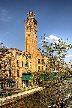 Salts Mill at the World-heritage site Saltaire, W.R. | |
|---|---|

| |
| Flag | |
| |
| [Interactive map] | |
| Area: | 6,081 square miles |
| Population: | 5,218,838 |
| County town: | York |
| Biggest town: | Leeds |
| County flower: | Harebell [1] |
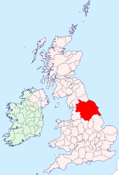
The County of York is by far the largest shire in the United Kingdom as well as the most populous. The northern boundary of Yorkshire is the River Tees, the eastern boundary is marked by the North Sea coast and the southern boundary the Humber Estuary and River Don and River Sheaf. The western boundary meanders along the western slopes of the Pennine Hills to again meet the River Tees. It is bordered by the counties of Durham, Lincoln, Nottingham, Derby, Chester, Lancaster and Westmorland. The county top is Mickle Fell at 2,585 ft.
Geography
Yorkshire is divided into three Ridings, whose boundaries meet at the walls of the City of York:
- the East Riding
- the North Riding
- the West Riding
The City of York within the walls is thus the only part of Yorkshire not within one of the three Ridings.
Wapentakes
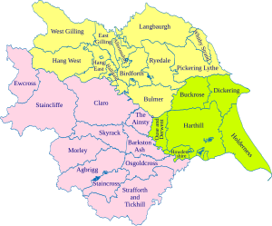
The Ridings are divided into wapentakes, analogous to hundreds in other counties: (map)
- East Riding:
- North Riding:
- West Riding:
Cities
- York (county town)
- Bradford, W.R.
- Doncaster, W.R.
- Kingston-upon-Hull, E.R.
- Leeds, W.R.
- Ripon, W.R.
- Sheffield, W.R. (partly in Derbyshire)
- Wakefield, W.R.
Towns
The largest towns of Yorkshire include:
- Barnsley, W.R.
- Beverley, E.R.
- Bridlington, E.R.
- Castleford, W.R.
- Dewsbury, W.R.
- Harrogate, W.R.
- Huddersfield, W.R.
- Halifax, W.R.
- Keighley, W.R.
- Middlesbrough, N.R.
- Northallerton, N.R.
- Pontefract, W.R.
- Pudsey, W.R.
- Redcar, N.R.
- Rotherham, W.R.
- Scarborough, N.R.
- Skipton, W.R.
Within the borders of the county are areas which are widely considered to be among the greenest in England, due to the vast stretches of unspoiled countryside in the Yorkshire Dales and North York Moors and to the open aspect of some of the major cities.[1][2] Yorkshire has sometimes been nicknamed "God's Own County".[3] The emblem of Yorkshire is the white rose of the royal House of York, which as displayed on a dark blue background forms the Flag of Yorkshire.[4] Yorkshire Day, held on 1 August, is a celebration of the general culture of Yorkshire, ranging from its history to its own dialect.[5]
Physical and geological
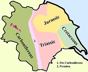
In Yorkshire there is a very close relationship between the major topographical areas and the geological period in which they were formed. The Pennine chain of hills in the west is of Carboniferous origin. The central vale is Permo-Triassic. The North York Moors in the north-east of the county are Jurassic in age while the Yorkshire Wolds to the south-seast are Cretaceous chalk uplands.
Yorkshire is drained by several rivers. In western and central Yorkshire the many rivers empty their waters into the River Ouse which reaches the North Sea via the Humber Estuary.[6] The most northerly of the rivers in the Ouse system is the River Swale, which drains Swaledale before passing through Richmond and meandering across the Vale of Mowbray. Next, draining Wensleydale, is the River Ure, which joins the Swale east of Boroughbridge. The River Nidd rises on the edge of the Yorkshire Dales National Park and flows along Nidderdale before reaching the Vale of York.[6]
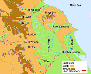
The Ouse is the name given to the river after its confluence with the Ure at Ouse Gill Beck. The River Wharfe, which drains Wharfedale, joins the Ouse upstream of Cawood.[6] The Rivers Aire and Calder are more southerly contributors to the River Ouse and the most southerly Yorkshire tributary is the River Don, which flows northwards to join the main river at Goole. In the far north of the county the River Tees flows eastwards through Teesdale and empties its waters into the North Sea downstream of Middlesbrough. The smaller River Esk flows from west to east at the northern foot of the North York Moors to reach the sea at Whitby.[6] The River Derwent rises on the North York Moors, flows south then westwards through the Vale of Pickering then turns south again to drain the eastern part of the Vale of York. It empties into the River Ouse at Barmby on the Marsh.[6] To the east of the Yorkshire Wolds the River Hull flows southwards to join the Humber Estuary at Kingston upon Hull. The western Pennines are served by the River Ribble which drains westwards into the Irish Sea close to Lytham St Annes in Lancashire.[6]
Transport
Road

The M62 motorway is Yorkshire's main east–west thoroughfare, and north–south routes are the M1 and the A1, with only the A1 continuing further north, with an upgrade to motorway status between Leeming and Barton. The other main north–south road in the region is the A19.[7]
The A64 road connects areas in the north-east of the county to the main body of motorways. The M1 was originally designed to finish at the A1 at Doncaster; this section became the M18 in December 1967. The section from the Thurcroft Interchange to Leeds (originally known as the Leeds-Sheffield Spur) was essentially designed to replace the A61, which is still the main road that connects the centres of Sheffield, Barnsley, Wakefield and Leeds, and continues through Harrogate and Ripon to Thirsk. The single-carriageway A1079 connects Hull to York, and has been exceeding its designed capacity for many years.
The main north–south and east–west routes interchange at a series of junctions to the south and east of Leeds, near Castleford. Leeds and Bradford have inner-city urban motorways, while Sheffield has the Sheffield Parkway and Hull has the Clive Sullivan Way (A63) which connect the city centres with the motorway network. Leeds has an inner-ring road network made mostly out of purpose-built motorway stretches which is mostly sub-terrain to the north of the city centre. Bradford, Huddersfield, Sheffield and York have inner-ring roads made by re-aligning existing roads while Halifax has a town-centre relief scheme made up of the Aachen Way and the North Bridge flyovers. The Office of the Traffic Commissioner central office is on the B6159 in east Leeds (Hillcrest House), which processes England and Wales LGV and PSV licences.
The Humber Bridge, the tallest bridge in the UK at 538 feet, was the world's longest suspension bridge from 17 July 1981 until 5 April 1998; it was built to connect with a proposed new town near the A15/M180 interchange in Lincolnshire.
Rail

The central hubs of the rail network in the county are Leeds, Sheffield and York. The East Coast Main Line passes through Leeds and York. The Midland Main Line finishes at Sheffield, with a less regular service to Leeds. East–west routes run to Manchester and Liverpool.[8] Leeds has a fairly extensive commuter network and an electrified section in the north of Bradford provides many commuter services. Sheffield has a smaller commuter rail network and there are also less extensive systems in Doncaster, Huddersfield, Wakefield and Harrogate, which connect the districts of the settlements to the centre by rail. The express service between Leeds and Huddersfield is notably quick.
The north of Yorkshire has a skeleton train network, with Scarborough and York being the main destinations. The Yorkshire Coast Line connects Hull to Scarborough. The Hull to York Line runs along the north of the Humber through Selby, and takes in Sherburn-in-Elmet and nearby rural stations south of York, being of great use to commuters to York since being reopened in the 1980s.
The county is home to a rail land speed record. On 1 November 1987, an InterCity 125 travelled at 148 mph between Northallerton and Thirsk.[9]
Mass transit

Only Sheffield has its own mass-transit system, the Sheffield Supertram. Leeds and Bradford have more developed commuter rail systems but lack any mass transit system. The Leeds Supertram was an approved scheme in Leeds. However, the funding was pulled and the scheme has been replaced by the proposed Leeds Trolleybus scheme. In the past Bradford, Halifax, Huddersfield, Kingston upon Hull, Leeds, Rotherham, Sheffield and York have all had mass-transit systems.
Air

Airports in the county are Leeds Bradford Airport at Yeadon and Doncaster Sheffield Airport (which opened in April 2005 on the former RAF Finningley) near Doncaster. Leeds Bradford Airport is the largest in the region by passenger numbers, and Robin Hood boasts the longest runway (9,491 ft) of any airport in the county, although it is partly in Nottinghamshire.
Sheffield City Airport formerly served the city of Sheffield. However, the airport struggled to attract many scheduled services and closed following the opening of Doncaster Sheffield Airport.
Water
Hull has daily ferries (former North Sea Ferries) to Zeebrugge and Rotterdam.[10] Hull also has a large freight port and an active fishing port. Goole is Britain's most inland port and is used mostly for importing commodities such as coal and timber.
The county also has a canal network. The Leeds and Liverpool Canal links the West Riding with Lancashire and the Aire and Calder Navigation links Leeds and the coal fields of Yorkshire with the ports to the east. There are also several smaller canals, often built for quite specific purposes. Many stretches of the smaller canals in the county have been backfilled. The steepest locks in Britain are at Bingley – Bingley Five Rise Locks, built by John Longbotham, who designed the canal.
History
- Main article: History of Yorkshire
The area of Yorkshire was unified under the name of the kingdom of Deira by King Edwin in AD 626.[11] In the 9th century the Danish settlers knew it as Jörvikskir. The Danes organised Yorkshire into wapentakes and the wapentakes into three areas which all met at the capital, Jörvik. These thirds were each called a thridjungr, which became thriding and ultimately Riding in English. The name Yorkshire first appeared in writing in the Anglo-Saxon Chronicle in 1065.
Following the Norman Conquest in 1066, Yorkshire was subject to the punitive harrying of the North, which caused great hardship. The county proved to be notable for uprisings and rebellions through to the Tudor period. During the industrial revolution, the West Riding became the second most important manufacturing area in the United Kingdom, while the predominant industries of the East and North Ridings remained fishing and agriculture. In modern times, the Yorkshire economy suffered from a decline in manufacturing which affected its traditional coal, steel, wool and shipping industries.
Sport
Cricket
Yorkshire County Cricket Club is one of eighteen first-class county clubs within the domestic cricket structure. The club's limited-overs team is called the Yorkshire Vikings. Yorkshire teams formed by earlier organisations, essentially the old Sheffield Cricket Club, played top-class cricket from the 18th century and the county club has always held first-class status. Yorkshire have competed in the County Championship since the official start of the competition in 1890 and have played in every top-level domestic cricket competition.
Yorkshire play most of their home games at the Headingley Cricket Ground in Leeds. Another significant venue is at North Marine Road Ground, Scarborough, which houses the annual Scarborough Festival. Yorkshire has historically used other locations including Bramall Lane, Sheffield, which was the club's original home; Horton Park Avenue, Bradford; St George's Road Cricket Ground, Harrogate; The Circle, Kingston upon Hull; and Acklam Park, Middlesbrough.
Football
The county has a very long tradition in the sport; it is officially recognised by FIFA as being the birthplace of club football as the world's oldest club Sheffield F.C. was formed in Sheffield during 1857.[12] Two men from Sheffield codified a set of rules for the game in 1857, these were known as the Sheffield rules and the Football Association rules which were created in 1863 were based in part on them. Ebenezer Cobb Morley was the first secretary of The Football Association, its second ever president and the man who drafted the FA's laws of the game at his home in Hull.
The world's first ever inter-club match took place on 26 December 1860 in Sheffield; the match was between Sheffield F.C. and a newly formed club named Hallam F.C.
Professional football clubs representing Yorkshire include Barnsley, Bradford City, Doncaster Rovers, Huddersfield Town, Hull City, Leeds United, Middlesbrough, Rotherham United, Sheffield United and Sheffield Wednesday.
Rugby league
Rugby league was founded in Yorkshire in 1895 at the George Hotel in Huddersfield when 22 clubs broke away from the Rugby Football Union to form the Northern Rugby Football Union which later changed its name to the Rugby Football League.
The first winners of the newly formed league were Bradford-based team Manningham F.C. in 1895. Between 1896 and 1900 teams either played in the Yorkshire or Lancashire League depending on geographical location but still competed in the Challenge Cup. In the early years of the competition Huddersfield were the dominant force, winning multiple league titles between 1910s, and 1940s.
Rugby League clubs representing Yorkshire include Castleford Tigers, Huddersfield Giants, Hull F.C., Hull Kingston Rovers, Leeds Rhinos, Wakefield Trinity, Batley Bulldogs, Bradford Bulls, Dewsbury Rams, Doncaster, Featherstone Rovers, Halifax, Sheffield Eagles, Hunslet, Keighley Cougars and York City Knights.
Cycling
The Tour de Yorkshire is a road cycling race in Yorkshire, which started in May 2015. It is rated as a 2.HC event as part of the UCI Europe Tour. From 2015 to 2017 it was a three-day race but in 2018 it expanded to four days, starting on Thursday 3 May and finishing on Sunday 6 May.
The idea for the race arose as a legacy event following the significant success of the visit of the 2014 Tour de France to the county. The first two stages of the 2014 Tour, from Leeds to Harrogate, and York to Sheffield, were nicknamed Le Tour de Yorkshire.[13]
Gallery
-
City Hall, Bradford, W.R.
-
Fountains Abbey, W.R.
-
Victoria Square, Holmfirth, W.R.
-
The Guildhall, Kingston-upon-Hull, E.R.
-
Town Hall, Leeds, W.R.
-
The county top, Mickle Fell, N.R.
-
Transporter Bridge, Middlesbrough, N.R.
-
Scarborough, N.R.
-
Town Hall and Peace Gardens, Sheffield, W.R.
-
The Shambles, York
References
- ↑ Benjamin, Alison; Wainwright, Martin (20 October 2007). "And the winner of the award for the greenest city in Britain is ... Bradford". London: Guardian Unlimited. http://www.guardian.co.uk/environment/2007/oct/20/communities?gusrc=rss&feed=networkfront. Retrieved 24 October 2007.
- ↑ "Green space conference comes to UK's 'greenest city'". Yorkshire Forward. 23 March 2006. Archived from the original on 18 November 2006. http://web.archive.org/web/20061118034333/http://www.yorkshire-forward.com/www/view.asp?content_id=2934&parent_id=263. Retrieved 24 October 2007.
- ↑ "God's own county". London: Guardian Unlimited. 2 June 2006. http://www.guardian.co.uk/travel/2006/jun/02/travelnews.shortbreaks.unitedkingdom. Retrieved 24 October 2007.
- ↑ "Yorkshire (United Kingdom)". CRWFlags.nom. http://www.crwflags.com/fotw/flags/gb-en-ys.html. Retrieved 25 October 2007.
- ↑ "Yorkshire Day". Army.mod.uk. 18 February 2008. http://www2.army.mod.uk/yorkshire_regiment/regiment/history/battle_honours/yorkshire_day.htm. Retrieved 3 October 2008.
- ↑ 6.0 6.1 6.2 6.3 6.4 6.5 British Canoe Union, Yorkshire and Humberside Region, Access and Recreation Committees ; prepared by Mike Twiggs and David Taylor. (1992). Yorkshire Rivers: A Canoeists Guide. Menasha Ridge Press. ISBN 978-1-871890-16-7.
- ↑ Philips Motoring Atlas:Britain. London: Philips. 2005.
- ↑ "Network Rail". Networkrailmediacentre.co.uk. http://www.networkrailmediacentre.co.uk/Content/Detail.asp?ReleaseID=3919&NewsAreaID=2&SearchCategoryID=2.
- ↑ 43102 125 Group
- ↑ "Hull to Zeebrugge ferries to Belgium – P&O Ferries". Poferries.com. http://www.poferries.com/tourist/content/pages/template/routes_hull_-_zeebrugge_routes_-_hull_-_zeebrugge.htm;jsessionid=ac10182d30d8e78b0c6e70f44aa9b662eecdf72aec4f.e38Mc34Ma3iKa40Ma3aObxyRbxyLe6fznA5Pp7ftolbGmkTy?WT.srch=1?TYPE=aff.
- ↑ "The Founding of Yorkshire (Deira)". Yorkshire Devolution Movement. https://yorkshiredevolution.co.uk/the-founding-of-Yorkshire.html.
- ↑ TheFA.com. "World's Oldest Football Club". https://archive.is/20071029052205/http://www.thefa.com/TheFA/NewsFromTheFA/Postings/2006/12/OldestClub.htm. Retrieved 27 June 2007.
- ↑ "Le Tour de Yorkshire". BBC News. 5 July 2014. https://www.bbc.co.uk/news/in-pictures-28176036. Retrieved 6 July 2014.
Outside links
| Counties of the United Kingdom |
|---|
|
Aberdeen • Anglesey • Angus • Antrim • Argyll • Armagh • Ayr • Banff • Bedford • Berks • Berwick • Brecknock • Buckingham • Bute • Caernarfon • Caithness • Cambridge • Cardigan • Carmarthen • Chester • Clackmannan • Cornwall • Cromarty • Cumberland • Denbigh • Derby • Devon • Dorset • Down • Dumfries • Dunbarton • Durham • East Lothian • Essex • Fermanagh • Fife • Flint • Glamorgan • Gloucester • Hants • Hereford • Hertford • Huntingdon • Inverness • Kent • Kincardine • Kinross • Kirkcudbright • Lanark • Lancaster • Leicester • Lincoln • Londonderry • Merioneth • Middlesex • Midlothian • Monmouth • Montgomery • Moray • Nairn • Norfolk • Northampton • Northumberland • Nottingham • Orkney • Oxford • Peebles • Pembroke • Perth • Radnor • Renfrew • Ross • Roxburgh • Rutland • Selkirk • Shetland • Salop • Somerset • Stafford • Stirling • Suffolk • Surrey • Sussex • Sutherland • Tyrone • Warwick • West Lothian • Westmorland • Wigtown • Wilts • Worcester • York |


