Denbighshire: Difference between revisions
No edit summary |
Picture |
||
| Line 3: | Line 3: | ||
|welsh=Sir Ddinbych | |welsh=Sir Ddinbych | ||
|map image=DenbighshireBrit6.PNG | |map image=DenbighshireBrit6.PNG | ||
|picture= | |picture=Cefn castell - geograph.org.uk - 156229.jpg | ||
|picture caption= | |picture caption=Cefn Castell | ||
|area=640 square miles | |area=640 square miles | ||
|population={{hcspop|25}} | |population={{hcspop|25}} | ||
|county town=[[Denbigh]] | |county town=[[Denbigh]] | ||
}} | }} | ||
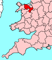
The '''County of Denbigh''' is a [[Counties of the United Kingdom|shire]] in northern [[Wales]]. It is a maritime county, bounded to the north by the [[Irish Sea]], to the east by [[Flintshire]], [[Cheshire]] and [[Shropshire]], to the south by [[Montgomeryshire]] and [[Merionethshire]], and to the west by [[Caernarfonshire]]. | The '''County of Denbigh''' is a [[Counties of the United Kingdom|shire]] in northern [[Wales]]. It is a maritime county, bounded to the north by the [[Irish Sea]], to the east by [[Flintshire]], [[Cheshire]] and [[Shropshire]], to the south by [[Montgomeryshire]] and [[Merionethshire]], and to the west by [[Caernarfonshire]]. | ||
==Geography== | ==Geography== | ||
In the south and west of the county, the mountains of the Clwydian Range rise from 1,000 to 2,500- | In the south and west of the county, the mountains of the Clwydian Range rise from 1,000 to 2,500-feet high. The east is hilly. There is some level ground along the coastal strip. The highest points are Moel Sych and Cader Berwyn at 2,713 feet. [[Pistyll Rhaeadr]] is a spectacular 240-ft waterfall. The chief rivers are the [[River Clwyd]] and the [[River Dee]]. The [[River Conwy]] runs north along the western boundary. | ||
===Towns and villages=== | ===Towns and villages=== | ||
Revision as of 22:38, 30 March 2011
| Denbighshire Welsh: Sir Ddinbych United Kingdom | |
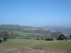
 Cefn Castell | |
|---|---|
| Duw â digon (God is sufficient) | |

| |
| [Interactive map] | |
| Area: | 640 square miles |
| Population: | Template:Hcspop |
| County town: | Denbigh |
| County flower: | Limestone woundwort [1] |
The County of Denbigh is a shire in northern Wales. It is a maritime county, bounded to the north by the Irish Sea, to the east by Flintshire, Cheshire and Shropshire, to the south by Montgomeryshire and Merionethshire, and to the west by Caernarfonshire.
Geography
In the south and west of the county, the mountains of the Clwydian Range rise from 1,000 to 2,500-feet high. The east is hilly. There is some level ground along the coastal strip. The highest points are Moel Sych and Cader Berwyn at 2,713 feet. Pistyll Rhaeadr is a spectacular 240-ft waterfall. The chief rivers are the River Clwyd and the River Dee. The River Conwy runs north along the western boundary.
Towns and villages
Parishes
- Abenbury
- Abergele
- Acton
- Betws Yn Rhos
- Bro Garmon
- Broughton
- Brymbo
- Bryneglwys
- Caia Park
- Cefn
- Cefnmeiriadog
- Ceiriog Ucha
- Cerrigydrudion
- Chirk
- Clocaenog
- Coedpoeth
- Colwyn Bay
- Cyffylliog
- Denbigh
- Derwen
- Efenechtyd
- Eglwysbach
- Erbistock
- Esclusham
- Glyntraian
- Gresford
- Gwersyllt
- Henllan
- Holt
- Isycoed
- Kinmel Bay and Towyn
- Llanarmon-yn-Ial
- Llanbedr Dyffryn Clwyd
- Llanddulas and Rhyd-y-Foel
- Llandegla
- Llandyrnog
- Llanelidan
- Llanfair Dyffryn Clwyd
- Llanfair Talhaiarn
- Llanferres
- Llanfihangel Glyn Myfyr
- Llangedwyn
- Llangernyw
- Llangollen
- Llangollen Rural
- Llangwm
- Llangynhafal
- Llannefydd
- Llanrhaeadr-ym-Mochnant
- Llanrhaeadr-Yng-Nghinmeirch
- Llanrwst
- Llansanffraid Glan Conwy
- Llansannan
- Llansantffraid Glyn Ceiriog
- Llansilin
- Llantysilio
- Llanynys
- Llay
- Llysfaen
- Marchwiel
- Minera
- Mochdre
- Nantglyn
- Offa
- Old Colwyn
- Pentrefoelas
- Penycae
- Rhos-on-Sea
- Rhosddu
- Rhosllanerchrugog
- Rossett
- Ruabon
- Ruthin
- Sesswick
- Trefnant
This county article is a stub: help to improve Wikishire by building it up.
| Counties of the United Kingdom |
|---|
|
Aberdeen • Anglesey • Angus • Antrim • Argyll • Armagh • Ayr • Banff • Bedford • Berks • Berwick • Brecknock • Buckingham • Bute • Caernarfon • Caithness • Cambridge • Cardigan • Carmarthen • Chester • Clackmannan • Cornwall • Cromarty • Cumberland • Denbigh • Derby • Devon • Dorset • Down • Dumfries • Dunbarton • Durham • East Lothian • Essex • Fermanagh • Fife • Flint • Glamorgan • Gloucester • Hants • Hereford • Hertford • Huntingdon • Inverness • Kent • Kincardine • Kinross • Kirkcudbright • Lanark • Lancaster • Leicester • Lincoln • Londonderry • Merioneth • Middlesex • Midlothian • Monmouth • Montgomery • Moray • Nairn • Norfolk • Northampton • Northumberland • Nottingham • Orkney • Oxford • Peebles • Pembroke • Perth • Radnor • Renfrew • Ross • Roxburgh • Rutland • Selkirk • Shetland • Salop • Somerset • Stafford • Stirling • Suffolk • Surrey • Sussex • Sutherland • Tyrone • Warwick • West Lothian • Westmorland • Wigtown • Wilts • Worcester • York |