Surrey: Difference between revisions
| Line 61: | Line 61: | ||
===Later Mediæval Surrey=== | ===Later Mediæval Surrey=== | ||
[[File: | [[File:Guildford castle 1.jpg|200px|right|thumb|Guildford Castle]] | ||
In 1088, King William II granted William de Warenne the title of Earl of Surrey as a reward for Warenne's loyalty during the rebellion that followed the death of William I. When the male line of the Warennes became extinct in the 14th century the earldom was inherited by the Fitzalan Earls of Arundel. The Fitzalan line of Earls of Surrey became extinct in 1415 but the title was revived in the late 15th century for the Howard family who still hold it, the Duke of Norfolk uses the family name Fitzalan-Howard and his heir is by courtesy Earl of Arundel and Surrey. | In 1088, King William II granted William de Warenne the title of Earl of Surrey as a reward for Warenne's loyalty during the rebellion that followed the death of William I. When the male line of the Warennes became extinct in the 14th century the earldom was inherited by the Fitzalan Earls of Arundel. The Fitzalan line of Earls of Surrey became extinct in 1415 but the title was revived in the late 15th century for the Howard family who still hold it, the Duke of Norfolk uses the family name Fitzalan-Howard and his heir is by courtesy Earl of Arundel and Surrey. | ||
Guildford Castle, one of many fortresses originally established by the Normans as part of the process of subjugating the country, was developed as a royal palace in the 12th century. [[Farnham]] Castle was built during the 12th century as a residence for the Bishop of Winchester, while other stone castles were constructed in the same period at [[Bletchingley]] by the de Clares and at [[Reigate]] by the Warennes. | Guildford Castle, one of many fortresses originally established by the Normans as part of the process of subjugating the country, was developed as a royal palace in the 12th century. [[Farnham]] Castle was built during the 12th century as a residence for the Bishop of Winchester, while other stone castles were constructed in the same period at [[Bletchingley]] by the de Clares and at [[Reigate]] by the Warennes. | ||
[[File:SouthThamesRunnymede.jpg|200px|right|thumb|Runnymede]] | |||
After King John lost his struggle with the barons, he was taken in June 1215 to [[Runnymede]], a meadow in north-western Surrey, where he sealed Magna Carta. The next year Surrey was overrun by forces supporting Prince Louis of France, who passed through on their way from London to [[Winchester]] and back and occupied Guildford and Reigate castles. | After King John lost his struggle with the barons, he was taken in June 1215 to [[Runnymede]], a meadow in north-western Surrey, where he sealed Magna Carta. The next year Surrey was overrun by forces supporting Prince Louis of France, who passed through on their way from London to [[Winchester]] and back and occupied Guildford and Reigate castles. | ||
Revision as of 22:36, 30 April 2011
| Surrey United Kingdom | |
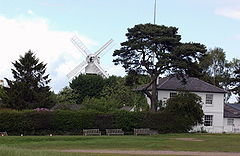 Wimbledon Common | |
|---|---|

| |
| Flag | |
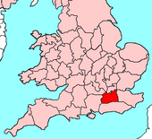
| |
| [Interactive map] | |
| Area: | 758 square miles |
| Population: | 2,975,836 |
| County town: | Guildford |
| County flower: | Cowslip [1] |
The County of Surrey is a shire in the southeast of Great Britain. It is one of the "Home Counties".
Surrey's northern border is the River Thames, across which lies Middlesex. Its southern border is with Sussex in the hills. To the east lies Kent and to the west Hampshire and Berkshire. The county town is Guildford.
The county has no one character for a while much of it has the nature of gentle rural life, the whole of north-eastern Surrey is within the metropolitan conurbation stretching out from London, within which are some parks and green areas but otherwise it is a vast, continuous urban sprawl, a mixture of poor neighbourhoods and wealthy.
Geography

Surrey is divided in two by the chalk ridge of the North Downs, running east-west. The ridge is pierced by Surrey's two principal rivers, the Wey and the Mole, both of which are tributaries of the Thames, which forms Surrey's northern border. To the north of the Downs the land is mostly flat, forming part of the basin of the Thames. The geology of this area is dominated by London Clay in the east, Bagshot Sands in the west and alluvial deposits along the rivers. To the south of the Downs in the western part of the county are the sandstone Surrey Hills, while further east is the plain of the Low Weald, rising in the extreme south-east to the edge of the hills of the High Weald. The Downs and the area to the south form part of a concentric pattern of geological deposits which also extends across southern Kent and most of Sussex, predominantly composed of Wealden Clay, Lower Greensand and the chalk of the Downs.
The metropolitan parts of Surrey, in the Brixton, Kingston and Wallington Hundreds, are within the Thames Basin. The soil is largely London clay. The ground is generally lowlying and indeed close to the Thames in the very northeast some areas are below sea level. Gentle hills rise in places. This area is not one of unbroken brick and tarmac: there are several parks, the largest being Richmond Park of 2,360 acres between Richmond and East Sheen, a royal park grazed by herds of deer. Close by are the Old Deer Park, Richmond Hill, Kew Gardens and Wimbledon Common. Wimbledon Common is 1140 acres of wild Surrey countryside, hemmed in but untamed by the townscape around it. Wandsworth Common and Clapham Common cover 175 acres and 220 acres respectively, and there re many other smaller green spaces.
Beyond the urban sprawl of the northeast and curbing its onward spread, a great deal of Surrey's land is in the Metropolitan Green Belt.
The North Downs stretch across Surrey from Farnham in the very west into Kent, falling into the sea as the White Cliffs of Dover. In Surrey the Downs provide a fine, wild landscape, dotted with pretty villages and hillside farms. The easternmost part forms the Hogsback, a narrow ridge running in a straight line from Farnham to Guildford and carrying the road between the two. The River Wey cuts through at Guildford, a narrow gap funnelling the main roads to a point, before the hills rise up again to the east and broaden into that landscape what has come to be known as the essence of rural Surrey.
The rural parts of Surrey contain a good deal of mature woodland and appropriately a symbol of Surrey of longstanding is the oak sprig. Among its many notable beauty spots are Box Hill, Leith Hill, Frensham Ponds, Newlands Corner and Puttenham & Crooksbury Commons. Box Hill is believed to be the oldest untouched area of natural woodland in the United Kingdom. Heathland is also found in the west of the county.
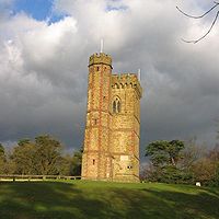
Agriculture not being intensive, there are many commons and an extensive network of footpaths and bridleways including the North Downs Way, a scenic long-distance path. Accordingly, Surrey provides much in the way of rural leisure activities, and many farms have horses; riding stables are common.
The highest elevation in Surrey is Leith Hill near Dorking, standing 965 feet above sea level and is the highest point in south-eastern England after Walbury Hill in Berkshire. In 1776 a tower was built on top of Leith Hill to take the total height to 1,000 feet in order to make it into a mountain.
Towns and villages
The largest towns in Surrey are in the northeast, where the distinction between towns is blurred and population comparisons rendered impossible. Here though most of the county's population live, and to this part and to Middlesex across the Thames many more commute each working day.
The largest town outside the metropolitan conurbation is the county town, Guildford, with a population of 66,773. Woking comes a close second with 62,796.
In the west, there is a smaller conurbation straddling the Hampshire-Surrey border, including Camberley and Farnham in Surrey and Farnborough in Hampshire.
History
British and Roman Surrey
Before Roman times, the area today known as Surrey was very probably occupied by the Atrebates tribe, who are known to have controlled the southern bank of the Thames from Roman texts describing the tribal relations between them and the powerful Catuvellauni on the north bank. In about 42 AD, King Verica of the Atrebates appealed for Roman help against the Catuvellauni under King Togodumnus who had subdued the Atrebates, which appeal led to the Roman invasion of the next year. The area of Surrey was traversed by Stane Street and other less well known Roman roads. There were Roman temples on Farley Heath and near Wanborough.
Early Anglo-Saxon period
During the 5th and 6th centuries Surrey was conquered and settled by Saxons. The names of a number of Saxon tribes who may have inhabited different parts of Surrey in this period have been conjectured on the basis of place names. These include the Godhelmingas (around Godalming), Tetingas (around Tooting) and Woccingas (between Woking and Wokingham in Berkshire). It has also been speculated that the Nox gaga and the Oht gaga tribes listed in the Mercian Tribal Hidage refer to two distinct groups living in Surrey. They were valued together at 7,000 hides. Surrey may have formed part of a larger Middle Saxon kingdom or confederacy also including areas north of the Thames. The name Surrey is derived from Suþrige, meaning "southern region", and this may originate in its status as the southern half of the Middle Saxon territory or the southern reach of Mercian territory.
By the 7th century Surrey had became a frontier area disputed between the kingdoms of Kent, Essex, Sussex, Wessex and Mercia, until its permanent absorption by Wessex in 825. Despite this fluctuating situation it retained its identity as a coherent territorial unit. During the 7th century Surrey became Christian and initially formed part of the East Saxon diocese of London, indicating that it was under East Saxon rule at that time, but Surrey was later transferred to the West Saxon diocese of Winchester. Its most important religious institution throughout the Anglo-Saxon period and beyond was Chertsey Abbey, founded in 666. At this point Surrey was evidently under Kentish domination, as the abbey was founded under the patronage of King Ecgberht of Kent. However, a few years later at least part of it was subject to Mercia, since in 673-5 further lands were given to Chertsey Abbey by Frithuwald, an underking whose charter to the Abbey calls him King of Surrey and states that he ruled under the sovereignty of Wulfhere of Mercia. A decade later Surrey passed into the hands of King Caedwalla of Wessex, who also conquered Kent and Sussex and founded a monastery at Farnham in 686. Surrey remained under the control of Caedwalla's successor Ine in the early 8th century. Its political history for most of the 8th century is unclear, although it may have been under South Saxon control around 722, but by 784-5 it had passed into the hands of King Offa of Mercia. Mercian rule continued until 825.
Kings of Surrey identified in this time are:
- Frithuwold (c.673 - 675)
- Frithuric? (675 - c.686)
The West Saxon and English shire
In 825, King Egbert of Wessex defeated the Mercians at the Battle of Ashdown and seized control of Surrey, along with Sussex, Kent and Essex. Surrey was incorporated into Wessex as a shire and continued thereafter under the rule of the West Saxon kings, who eventually became kings of all England.
In 851 an exceptionally large invasion force of Danes arrived in the mouth of the Thames on a fleet of about 350 ships. The army sacked Canterbury and London and defeated King Beorhtwulf of Mercia in battle, the Danes crossed the Thames into Surrey, but were slaughtered by a West Saxon army led by King Aethelwulf of Wessex in the Battle of Aclea, presumed to be Ockley in Surrey, bringing the invasion to an end. In 892 Surrey was the scene of another important battle when a large Danish army, variously reported at 200, 250 and 350 ship-loads, moved west from its encampment in Kent. It was intercepted and defeated at Farnham by an army led by Alfred the Great's son Edward, the future King Edward the Elder, and fled across the Thames towards Essex.
Kingston was the scene for the coronation of Aethelstan in 924 and Aethelred the Unready in 978, and, according to later tradition, of other tenth century Kings of the English too. The coronation stone still stands in Kingston. During the reign of Ethelred the Unready, Thorkell the Tall devastated Surrey during his harrying of England in 1009-11. In 1036 after Cnut's death, Alfred, the son of Aethelred the Unready, returned from Normandy, where he had been taken for safety as a child at the time of Cnut's conquest of England. Godwin, Earl of Wessex escorted him in an apparently friendly fashion to Guildford. Alfred's men were attacked as they slept and massacred by Godwin's followers, while the prince himself was blinded and imprisoned, dying shortly afterwards. This slaughter contributed to the antipathy between Godwin and Alfred's brother Edward the Confessor, who came to the throne in 1042 and indirectly led to the Norman invasion in 1066.
The Domesday Book records that the largest landowners in Surrey at the end of Edward's reign were Chertsey Abbey and Harold Godwinson, Earl of Wessex and later king, followed by the estates of King Edward himself. Apart from the abbey, most of whose lands were within the shire, Surrey was the not the principal focus of any major landowner's holdings. Given the vast and widespread landed interests and the national and international preoccupations of the king, the Abbot of Chertsey was therefore probably the most important figure in the local élite.
Later Mediæval Surrey
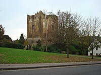
In 1088, King William II granted William de Warenne the title of Earl of Surrey as a reward for Warenne's loyalty during the rebellion that followed the death of William I. When the male line of the Warennes became extinct in the 14th century the earldom was inherited by the Fitzalan Earls of Arundel. The Fitzalan line of Earls of Surrey became extinct in 1415 but the title was revived in the late 15th century for the Howard family who still hold it, the Duke of Norfolk uses the family name Fitzalan-Howard and his heir is by courtesy Earl of Arundel and Surrey.
Guildford Castle, one of many fortresses originally established by the Normans as part of the process of subjugating the country, was developed as a royal palace in the 12th century. Farnham Castle was built during the 12th century as a residence for the Bishop of Winchester, while other stone castles were constructed in the same period at Bletchingley by the de Clares and at Reigate by the Warennes.

After King John lost his struggle with the barons, he was taken in June 1215 to Runnymede, a meadow in north-western Surrey, where he sealed Magna Carta. The next year Surrey was overrun by forces supporting Prince Louis of France, who passed through on their way from London to Winchester and back and occupied Guildford and Reigate castles.
Surrey had little political or economic importance in the Middle Ages. It was not the main power-base of any major aristocratic family or the seat of a bishopric, while its agricultural wealth was limited by its generally poor soils. Population pressure in the 12th and 13th centuries led to the beginning of the gradual deforestation and agricultural development of the Weald, an area which had hitherto remained wooded due to the exceptional difficulty of farming its heavy clay soil. Urban development, excepting the town of Southwark spreading out from the bridgehead of London Bridge, was sapped by the overshadowing predominance of London and the major towns in neighbouring shires, many of which benefited from access to the sea or from political or ecclesiastical eminence. Surrey did however achieve a significant degree of prosperity in the later Middle Ages through its role in the production of woollen cloth, England's main export industry, which in Surrey was centred on Guildford.
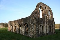
In 1082 a Cluniac abbey was founded at Bermondsey by Alwine, a wealthy English citizen of London. The first Cistercian monastery in England, Waverley Abbey, was founded in 1128. Over the next quarter-century monks spread out from here to found new houses, creating a network of twelve monasteries descended from Waverley across southern and central England. The 12th and early 13th centuries also saw the establishment of Augustinian]] priories at Merton, Send (Newark Priory), Tandridge, Southwark and Reigate. A Dominican friary was established at Guildford by Henry III's widow Eleanor of Provence and in the 15th century Henry V founded a Carthusian priory at Sheen. All were dissolved in the 16th-century Dissolution of the Monasteries, as was ancient Chertsey Abbey.
Early Modern Surrey
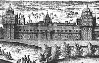
The Tudor monarchs favoured Surrey for palaces and indeed it was in a Surrey palace that the last of the house died. King Henry VII expanded an existing residence at Sheen into the magnificent Richmond Palace. His son, Henry VIII built a yet more spectacular palace; Nonsuch Palace near Ewell. The palace at Guildford Castle had fallen out of use long before, but a royal hunting lodge existed just outside the town. All these have since been demolished. Queen Elizabeth particularly favoured Richmond and here she died on 24 March 1603. From Richmond, Sir Robert Carey pelted north to bring news to King James in Edinburgh of his succession to the crown.
During the Cornish Rebellion of 1497 the rebels heading for London briefly occupied Guildford and fought a skirmish with a government detachment on Guildown outside the town, before marching on to Blackheath in Kent where they were crushed by a royal army. Wyatt's Rebellion in 1554 passed through what was then north-eastern Surrey on their way from Kent to London, briefly occupying Southwark and then crossing the Thames at Kingston after failing to storm London Bridge.
Surrey's cloth industry declined in the 16th century, and effectively collapsed in the 17th. The introduction of new furnace technology in the early 17th century led to an expansion of the iron industry in the Weald, whose rich deposits had been exploited since prehistoric times, but this hastened the extinction of the business as the mines were worked out. However, this period also saw the emergence of important new industries, centred on the valley of the Tillingbourne. The production of brass goods and wire in this area was relatively short-lived, but the manufacture of paper and gunpowder proved more enduring. For a time in the mid-17th century the Surrey mills were the main producers of gunpowder in England. The Wey Navigation, opened in 1653, was one of England's first canal systems.
Bankside in Southwark was the principal entertainment district of early modern London. This was due to its convenient location outside the jurisdiction of the government of the City of London, since the social control exercised over this London suburb by the local authorities of Surrey was less effectively restrictive. As a result this was where the city's theatres were located and was the setting for the golden age of Elizabethan and Jacobean theatre, with the work of playwrights including William Shakespeare, Christopher Marlowe, Ben Jonson and John Webster being performed in playhouses along the south bank of the Thames.
Surrey almost entirely escaped the direct impact of fighting during the English Civil War: the local Parliamentarian gentry led by Sir Richard Onslow were able to secure the county without difficulty on the outbreak of war. Farnham Castle was briefly occupied by the advancing Royalists in late 1642, but was easily stormed by the Parliamentarians under Sir William Waller. A new Royalist offensive in late 1643 saw skirmishing around Farnham between Waller's forces and Ralph Hopton's Royalists, but these brief incursions into the western fringes of Surrey marked the limits of Royalist advances on the county. During a political crisis in summer 1647 Sir Thomas Fairfax's army passed through Surrey on its way to occupy London, and subsequent billeting of troops in Surrey caused considerable discontent. In the brief Second Civil War of 1648 the Earl of Holland entered Surrey in July hoping to ignite a Royalist revolt. He raised his standard at Kingston and advanced south, but found little support. After confused manoeuvres between Reigate and Dorking as Parliamentary troops closed in, his force of 500 men fled northwards and was overtaken and routed at Kingston.
Modern history
The growth of Surrey towns began with the Turnpike Trusts, which built vastly improved roads, from the late 18th century, but expanded rapidly with the coming of the railways.
Surrey had the world's first public railway, the Surrey Iron Railway built in 1803. It was at first for horse-drawn carriages, but closed in 1846, its route reopened on new rails in 1855 for steam locomotives, though the new railways had already been spreading elsewhere. The railways created the London Commuter Belt and the growth of the suburbs which are a feature of muh of Surrey today.
The London conurbation spread swiftly across north-eastern Surrey. In 1800 it extended only to Vauxhall; a century later the city's growth had reached as far as Putney and Streatham. It continued in the 20th century, engulfing Croydon, Kingston upon Thames and many smaller towns.
During the later 19th century Surrey became increasingly important in the development of architecture in Britain and the wider world. Its traditional building forms were of key significance in shaping the widespread trend for English vernacular architecture associated with the Arts and Crafts Movement. Its influence was driven in particular by the work of Richard Norman Shaw, and would continue to shape domestic building through the 20th century. The architectural prominence of Surrey peaked in the 1890s, when it was the focus for the early work of Edwin Lutyens and Charles Voysey among others, which was of global importance.
In 1871, George Tomkyns Chesney's The Battle of Dorking led to an invasion scare and to the building of defensive emplacements on the Downs in case of invasion. During the Second World War this idea was developed further; a section of the GHQ Stop Line, a system of pillboxes, gun emplacements, anti-tank obstacles and other fortifications was constructed along the North Downs. This line, running from Somerset to Yorkshire, was intended as the principal fixed defence of London and the industrial core of England against the threat of invasion.
Hundreds
Surrey has 14 hundreds:
- Blackheath
- Brixton
- Copthorne
- Effingham Half-Hundred
- Elmbridge
- Farnham
- Godalming
- Godley
- Kingston
- Reigate
- Tandridge
- Wallington
- Woking
- Wotton
| Counties of the United Kingdom |
|---|
|
Aberdeen • Anglesey • Angus • Antrim • Argyll • Armagh • Ayr • Banff • Bedford • Berks • Berwick • Brecknock • Buckingham • Bute • Caernarfon • Caithness • Cambridge • Cardigan • Carmarthen • Chester • Clackmannan • Cornwall • Cromarty • Cumberland • Denbigh • Derby • Devon • Dorset • Down • Dumfries • Dunbarton • Durham • East Lothian • Essex • Fermanagh • Fife • Flint • Glamorgan • Gloucester • Hants • Hereford • Hertford • Huntingdon • Inverness • Kent • Kincardine • Kinross • Kirkcudbright • Lanark • Lancaster • Leicester • Lincoln • Londonderry • Merioneth • Middlesex • Midlothian • Monmouth • Montgomery • Moray • Nairn • Norfolk • Northampton • Northumberland • Nottingham • Orkney • Oxford • Peebles • Pembroke • Perth • Radnor • Renfrew • Ross • Roxburgh • Rutland • Selkirk • Shetland • Salop • Somerset • Stafford • Stirling • Suffolk • Surrey • Sussex • Sutherland • Tyrone • Warwick • West Lothian • Westmorland • Wigtown • Wilts • Worcester • York |