Carmarthenshire: Difference between revisions
No edit summary |
mNo edit summary |
||
| (22 intermediate revisions by 2 users not shown) | |||
| Line 1: | Line 1: | ||
{{Infobox county | {{Infobox county | ||
|name=Carmarthenshire | |name=Carmarthenshire | ||
|welsh=Sir | |welsh=Sir Gaerfyrddin | ||
|map image= | |map image=Carmarthenshire Brit Isles Sect 6.svg | ||
|picture= | |picture=The Boathouse - geograph.org.uk - 461239.jpg | ||
|picture caption= | |picture caption=The Boathouse and estuary, Laugharne | ||
|county town=[[Carmarthen]] | |county town=[[Carmarthen]] | ||
}} | }} | ||
The '''County of Carmarthen''' is a maritime [[Counties of the United Kingdom|shire]] in the south west of [[Wales]]. | The '''County of Carmarthen''' is a maritime [[Counties of the United Kingdom|shire]] in the south-west of [[Wales]], and at {{database|Carmarthenshire|area}} square miles it is the largest county in Wales, but only the 28th largest in the whole [[United Kingdom]]. | ||
Carmarthenshire lies on the sea where the [[Bristol Channel]] is opening onto the [[Atlantic Ocean|Atlantic]]. The coasts of Carmarthenshire curve around Carmarthen Bay, the quiet dip of the fields running into broad sandy beaches. | |||
The [[River Towy|Towy]] Valley crosses the county from its north-east and runs from the mountains, broadening from [[Llandovery]] and providing farmland down through [[Llandeilo]] to [[Carmarthen]], a little south of which the Towy opens into the middle of a three-branched an estuary with the [[River Gwendraeth|Gwendraeth]] and the [[River Taf|Taf]] into Carmarthen Bay. Off these rivers are many tidal creeks. | |||
The southern part of Carmarthen is generally low lying and pastoral. The north and east, beyond the Towyn Valley, are mountainous. | |||
The county's three largest towns are [[Llanelli]], [[Carmarthen]] and [[Ammanford]]. The [[county town]] is [[Carmarthen]], but the most populous town is [[Llanelli]], taken together with the suburban areas around it. About half of the county's population are Welsh-speakers. | |||
With its fertile land and agricultural produce, Carmarthenshire is known as the "Garden of Wales".<ref>[http://www.visitbritain.co.uk/things-to-see-and-do/itineraries/gardens/wales/carmarthenshire.aspx Visit Britain - Carmarthenshire]</ref> Its Welsh name is ''Sir Gaerfyrddin'' (''Caerfyrddin'' being Carmarthen) or ''Sir Gâr''. | |||
==Geography== | ==Geography== | ||
[[File:Llyn y Fan Fawr.jpg|thumb|250px|Llyn y Fan Fawr in the Black Mountain]] | |||
Carmarthenshire is bounded to the north by [[Cardiganshire]], to the west by [[Pembrokeshire]], to the east by [[Brecknockshire]] and [[Glamorgan]] and its south is washed by the waters of the [[Bristol Channel]]. | |||
The surface generally is upland and mountainous. Fforest Fawr and the Black Mountain extend into the east of the county and the Cambrian Mountains into the north. The south coast contains many fishing villages and sandy beaches. The highest point is | The surface generally is upland and mountainous. [[Fforest Fawr]] and the [[Black Mountain (range)|Black Mountain]] range extend into the east of the county and the [[Cambrian Mountains]] into the north. The south coast contains many fishing villages and sandy beaches. The highest point is [[Fan Brycheiniog]], reaching 2,525 feet, albeit that the mountain only reaches its summit in Brecknockshire. | ||
The | The shire is drained by several important rivers, especially the [[Towy]], which flows into the [[Bristol Channel]], and its several tributaries, such as the [[River Cothi]]. The Towy is the longest river flowing entirely within Wales and is noted for its trout and salmon fishing. Other rivers include the [[River Loughor|Loughor]] (which forms the eastern border with [[Glamorgan]]), and the [[Gwendraeth Fawr]]. | ||
The county's principal industries are agriculture, forestry, fishing and tourism. | |||
==History== | |||
Carmarthenshire has its early roots in the region formerly known as ''Ystrad Tywi'' (''Vale of [the river] Towy'') and part of the Principality of [[Deheubarth]] during the High Middle Ages, with the court at [[Dinefwr Castle|Dinefwr]]. | |||
There is evidence to show that the county of Carmarthen itself came into existence between 1270 and 1280, and following the Edwardian Conquest of Wales, it was formalised by the Statute of Rhuddlan in 1284. | |||
==Hundreds== | |||
[[File:Carmarthenshire Hundreds.svg|thumb|250px|The hundreds of Carmarthenshire]] | |||
The county has eight hundreds, originating as mediæval commotes: | |||
*[[Cathinog]] | |||
*[[Carnwallan]] | |||
*[[Cayo Hundred|Cayo]] | |||
*[[Derllys]] | |||
*[[Elvet Hundred|Elvet]] | |||
*[[Kidwelly Hundred|Kidwelly]] | |||
*[[Iscennen]] | |||
*[[Perfedd]] | |||
==Towns and villages== | ==Towns and villages== | ||
[[File:Carm Sgwar Guildhall.JPG|right|thumb|250px|Carmarthen Guildhall]] | |||
The county town is [[Carmarthen]], an ancient town, and it is from this town that the county takes its name. The name of Carmarthen is from the Welsh ''Caerfyrddin'', meaning "Myrddin's fort", and a legend has grown up that it is named after Merlin of Arthurian legend. | |||
The county's principal towns are: | |||
{| | |||
| | |||
*[[Ammanford]] | *[[Ammanford]] | ||
*[[Burry Port]] | |||
*[[Carmarthen]] ''([[county town]])'' | |||
*[[Kidwelly]] | *[[Kidwelly]] | ||
*[[Llanelli]] ''(largest town)'' | |||
*[[Llandeilo]] | |||
|valign="top"| | |||
*[[Llandovery]] | *[[Llandovery]] | ||
*[[ | *[[Newcastle Emlyn]] | ||
*[[Pendine]] | |||
*[[St Clears]] | *[[St Clears]] | ||
*[[Whitland]] | |||
|} | |||
For a full list of villages and hamlets, see [[:Category:Towns and villages in Carmarthenshire]] | |||
== | ===Civil communities=== | ||
{{parishliststart}} | {{parishliststart}} | ||
*[[Abergwili]] | *[[Abergwili]] | ||
*[[Abernant]] | *[[Abernant, Carmarthenshire|Abernant]] | ||
*[[Ammanford]] | *[[Ammanford]] | ||
*[[Betws]] | *[[Betws]] | ||
| Line 38: | Line 80: | ||
*[[Cilycwm]] | *[[Cilycwm]] | ||
*[[Cilymaenllwyd]] | *[[Cilymaenllwyd]] | ||
*[[Clynderwen]] | |||
*[[Cwmamman]] | *[[Cwmamman]] | ||
*[[Cynwyl Elfed]] | *[[Cynwyl Elfed]] | ||
| Line 73: | Line 116: | ||
*[[Llangyndeyrn]] | *[[Llangyndeyrn]] | ||
*[[Llangynin]] | *[[Llangynin]] | ||
*[[Llangynog]] | *[[Llangynog, Carmarthenshire|Llangynog]] | ||
*[[Llanllawddog]] | *[[Llanllawddog]] | ||
*[[Llanllwni]] | *[[Llanllwni]] | ||
| Line 96: | Line 139: | ||
*[[Quarter Bach]] | *[[Quarter Bach]] | ||
*[[St Clears]] | *[[St Clears]] | ||
*[[St Ishmael]] | *[[St Ishmael, Carmarthenshire|St Ishmael]] | ||
*[[Talley]] | *[[Talley]] | ||
*[[Trelech]] | *[[Trelech, Carmarthenshire|Trelech]] | ||
*[[Trimsaran]] | *[[Trimsaran]] | ||
*[[Whitland]] | *[[Whitland]] | ||
{{parishlistend}} | {{parishlistend}} | ||
{{ | ==Sites of Carmarthenshire== | ||
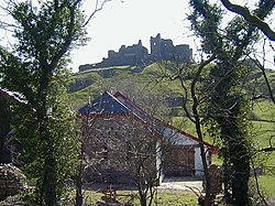
[[File:Careg Cennen Castle.jpg|thumb|right|250px|Carreg Cennen Castle]] | |||
{{UKPlacesKey}} | |||
===Castles=== | |||
{{i-Castle}} Castles: | |||
* Carreg Cennen Castle | |||
* {{i-NTE}} [[Dinefwr Castle|Dinefwr Park and Castle]] | |||
* [[Kidwelly Castle]] | |||
* [[Laugharne Castle]] | |||
* [[Llansteffan Castle]] | |||
===Other built heritage=== | |||
*{{i-NTE}} [[Aberdaunant farmhouse]], [[Llandeilo]] | |||
*[[Aberglasney House]] and Gardens | |||
*{{i-House}} [[Newton House, Llandeilo]] | |||
*[[Laugharne]] and the Dylan Thomas Boathouse | |||
*{{i-Abbey}} [[Talley Abbey]] | |||
===Landscape=== | |||
*[[Brechfa Forest]] | |||
*Carmel National Nature Reserve | |||
*[[Cefn Sidan]] | |||
*Millennium Coastal Park, [[Llanelli]] | |||
*[[National Botanic Garden of Wales]] | |||
*{{i-Park}} Pembrey Country Park | |||
*[[Pendine Sands]] | |||
*Usk Reservoir | |||
===Museums=== | |||
{{i-Museum}} Museums: | |||
*Carmarthenshire County Museum | |||
*{{i-NTE}} Dolaucothi Gold Mines, [[Pumsaint]] | |||
*[[Kidwelly]] Industrial Museum | |||
*National Woollen Museum | |||
*Parc Howard Museum | |||
*Pendine Museum of Speed ([[Pendine]]) | |||
*West Wales Museum of Childhood | |||
===Heritage railways=== | |||
{{i-Railway}} Railways: | |||
*[[Gwili Railway]] | |||
*[[Teifi Valley Railway]] | |||
*WWT National Wetlands Centre, [[Llanelli]] | |||
==Outside links== | |||
*[http://www.onebiggarden.com/Region/Carmarthenshire-R2-2.aspx Carmarthenshire] - South West Wales Tourist Board | |||
*[http://www.genuki.org.uk/big/wal/CMN/ Genuki: Research sources for Carmarthenshire] | |||
==References== | |||
{{Reflist}} | |||
{{British county}} | {{British county}} | ||
Latest revision as of 18:26, 20 October 2024
| Carmarthenshire Welsh: Sir Gaerfyrddin United Kingdom | |
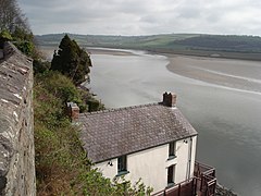 The Boathouse and estuary, Laugharne | |
|---|---|

| |
| Flag | |
| Rhyddid gwerin ffyniant gwlad (A free people a prosperous country) | |
| |
| [Interactive map] | |
| Area: | 937 square miles |
| Population: | 184,232 |
| County town: | Carmarthen |
| County flower: | Whorled caraway [1] |
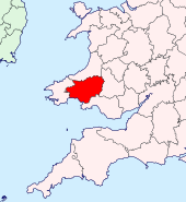
The County of Carmarthen is a maritime shire in the south-west of Wales, and at 937 square miles it is the largest county in Wales, but only the 28th largest in the whole United Kingdom.
Carmarthenshire lies on the sea where the Bristol Channel is opening onto the Atlantic. The coasts of Carmarthenshire curve around Carmarthen Bay, the quiet dip of the fields running into broad sandy beaches.
The Towy Valley crosses the county from its north-east and runs from the mountains, broadening from Llandovery and providing farmland down through Llandeilo to Carmarthen, a little south of which the Towy opens into the middle of a three-branched an estuary with the Gwendraeth and the Taf into Carmarthen Bay. Off these rivers are many tidal creeks.
The southern part of Carmarthen is generally low lying and pastoral. The north and east, beyond the Towyn Valley, are mountainous.
The county's three largest towns are Llanelli, Carmarthen and Ammanford. The county town is Carmarthen, but the most populous town is Llanelli, taken together with the suburban areas around it. About half of the county's population are Welsh-speakers.
With its fertile land and agricultural produce, Carmarthenshire is known as the "Garden of Wales".[1] Its Welsh name is Sir Gaerfyrddin (Caerfyrddin being Carmarthen) or Sir Gâr.
Geography
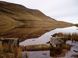
Carmarthenshire is bounded to the north by Cardiganshire, to the west by Pembrokeshire, to the east by Brecknockshire and Glamorgan and its south is washed by the waters of the Bristol Channel.
The surface generally is upland and mountainous. Fforest Fawr and the Black Mountain range extend into the east of the county and the Cambrian Mountains into the north. The south coast contains many fishing villages and sandy beaches. The highest point is Fan Brycheiniog, reaching 2,525 feet, albeit that the mountain only reaches its summit in Brecknockshire.
The shire is drained by several important rivers, especially the Towy, which flows into the Bristol Channel, and its several tributaries, such as the River Cothi. The Towy is the longest river flowing entirely within Wales and is noted for its trout and salmon fishing. Other rivers include the Loughor (which forms the eastern border with Glamorgan), and the Gwendraeth Fawr.
The county's principal industries are agriculture, forestry, fishing and tourism.
History
Carmarthenshire has its early roots in the region formerly known as Ystrad Tywi (Vale of [the river] Towy) and part of the Principality of Deheubarth during the High Middle Ages, with the court at Dinefwr.
There is evidence to show that the county of Carmarthen itself came into existence between 1270 and 1280, and following the Edwardian Conquest of Wales, it was formalised by the Statute of Rhuddlan in 1284.
Hundreds
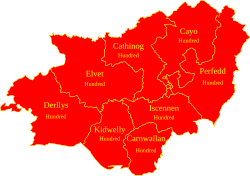
The county has eight hundreds, originating as mediæval commotes:
Towns and villages

The county town is Carmarthen, an ancient town, and it is from this town that the county takes its name. The name of Carmarthen is from the Welsh Caerfyrddin, meaning "Myrddin's fort", and a legend has grown up that it is named after Merlin of Arthurian legend.
The county's principal towns are:
|
For a full list of villages and hamlets, see Category:Towns and villages in Carmarthenshire
Civil communities
- Abergwili
- Abernant
- Ammanford
- Betws
- Bronwydd
- Carmarthen
- Cenarth
- Cilycwm
- Cilymaenllwyd
- Clynderwen
- Cwmamman
- Cynwyl Elfed
- Cynwyl Gaeo
- Dyffryn Cennen
- Eglwyscummin
- Gorslas
- Henllanfallteg
- Kidwelly
- Laugharne Township
- Llanarthney
- Llanboidy
- Llanddarog
- Llanddeusant
- Llanddowror
- Llandeilo
- Llandovery
- Llandybie
- Llandyfaelog
- Llanedi
- Llanegwad
- Llanelli
- Llanelli Rural
- Llanfair-ar-y-bryn
- Llanfihangel Aberbythych
- Llanfihangel-ar-arth
- Llanfihangel Rhos-y-corn
- Llanfynydd
- Llangadog
- Llangain
- Llangathen
- Llangeler
- Llangennech
- Llangunnor
- Llangyndeyrn
- Llangynin
- Llangynog
- Llanllawddog
- Llanllwni
- Llannon
- Llanpumsaint
- Llansadwrn
- Llansawel
- Llansteffan
- Llanwinio
- Llanwrda
- Llanybydder
- Llanycrwys
- Manordeilo and Salem
- Meidrim
- Myddfai
- Newcastle Emlyn
- Newchurch and Merthyr
- Pembrey and Burry Port Town
- Pencarreg
- Pendine
- Pontyberem
- Quarter Bach
- St Clears
- St Ishmael
- Talley
- Trelech
- Trimsaran
- Whitland
Sites of Carmarthenshire
| Key | |
| Cathedral/Abbey/Priory | |
| Accessible open space | |
| Amusement/Theme Park | |
| Castle | |
| Country Park | |
| Cadw | |
| Forestry Commission | |
| Heritage railway | |
| Historic House | |
| Museum (free/not free) | |
| National Trust | |
| Zoo | |
Castles
- Carreg Cennen Castle
 Dinefwr Park and Castle
- Kidwelly Castle
- Laugharne Castle
- Llansteffan Castle
Other built heritage
 Aberdaunant farmhouse, Llandeilo
- Aberglasney House and Gardens
 Newton House, Llandeilo
- Laugharne and the Dylan Thomas Boathouse
 Talley Abbey
Landscape
- Brechfa Forest
- Carmel National Nature Reserve
- Cefn Sidan
- Millennium Coastal Park, Llanelli
- National Botanic Garden of Wales
 Pembrey Country Park
- Pendine Sands
- Usk Reservoir
Museums
- Carmarthenshire County Museum
 Dolaucothi Gold Mines, Pumsaint
- Kidwelly Industrial Museum
- National Woollen Museum
- Parc Howard Museum
- Pendine Museum of Speed (Pendine)
- West Wales Museum of Childhood
Heritage railways
- Gwili Railway
- Teifi Valley Railway
- WWT National Wetlands Centre, Llanelli
Outside links
- Carmarthenshire - South West Wales Tourist Board
- Genuki: Research sources for Carmarthenshire
References
| Counties of the United Kingdom |
|---|
|
Aberdeen • Anglesey • Angus • Antrim • Argyll • Armagh • Ayr • Banff • Bedford • Berks • Berwick • Brecknock • Buckingham • Bute • Caernarfon • Caithness • Cambridge • Cardigan • Carmarthen • Chester • Clackmannan • Cornwall • Cromarty • Cumberland • Denbigh • Derby • Devon • Dorset • Down • Dumfries • Dunbarton • Durham • East Lothian • Essex • Fermanagh • Fife • Flint • Glamorgan • Gloucester • Hants • Hereford • Hertford • Huntingdon • Inverness • Kent • Kincardine • Kinross • Kirkcudbright • Lanark • Lancaster • Leicester • Lincoln • Londonderry • Merioneth • Middlesex • Midlothian • Monmouth • Montgomery • Moray • Nairn • Norfolk • Northampton • Northumberland • Nottingham • Orkney • Oxford • Peebles • Pembroke • Perth • Radnor • Renfrew • Ross • Roxburgh • Rutland • Selkirk • Shetland • Salop • Somerset • Stafford • Stirling • Suffolk • Surrey • Sussex • Sutherland • Tyrone • Warwick • West Lothian • Westmorland • Wigtown • Wilts • Worcester • York |