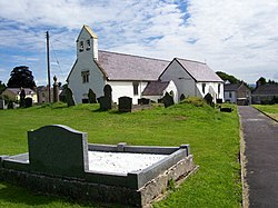
Llansadwrn
| Llansadwrn | |
| Carmarthenshire | |
|---|---|
 Llansadwrn Church | |
| Location | |
| Location: | 51°58’8"N, 3°54’18"W |
| Data | |
| Population: | 517 (2011[1]) |
| Post town: | Llanwrda |
| Postcode: | SA19 |
| Dialling code: | 01550 |
| Local Government | |
| Council: | Carmarthenshire |
| Parliamentary constituency: |
Carmarthen East and Dinefwr |
Llansadwrn is a small village and parish in the Perfedd hundred of Carmarthenshire. It is located in the countryside of the River Towy river valley, about half way between Llandovery to the north-east, and Llandeilo to the south-west, just off the A40 road.
History
According to tradition, it was founded by an early Christian saint, Sadwrn (fl. around AD 460).
Four miles to the west of the village are the ruins of Talley Abbey.
One mile to the west is the hamlet of Waunclunda, and above Waunclunda is an ancient fort. Little information is available about this fort, but it is believed to have been an Iron Age and then a Roman fort it is believed to be important for its potential archeology.[2]
The village is also believed to be the site of an important manor, Abermarlais Castle a fortified mansion, built in about the 14th century (Rees 1932). It was home to Sir Rhys ap Gruffydd who commanded the Welsh at Crécy (Jones 1987, 4). In the 1600s it was noted to have had 21 hearths - making it a notable house.[3] Also in the village is a Bronze age standing stone and Roman road.
References
- ↑ "Community population 2011". https://neighbourhood.statistics.gov.uk/dissemination/LeadKeyFigures.do?a=7&b=11125970&c=SA19+8LF&d=16&e=62&g=6492089&i=1001x1003x1032x1004&m=0&r=0&s=1428949220146&enc=1. Retrieved 13 April 2015.
- ↑ Stuff, Good. "Fan Camp, Llansadwrn, Carmarthenshire (Sir Gaerfyrddin)". https://ancientmonuments.uk/129563-fan-camp-llansadwrn. Retrieved 2019-01-21.
- ↑ "Archaeology in Wales - Ymddiriedolaeth Archaeolegol Dyfed - Dyfed Archaeological Trust". http://www.dyfedarchaeology.org.uk/HLC/HLCTowy/area/area209.htm. Retrieved 2019-01-21.
Outside links
| ("Wikimedia Commons" has material about Llansadwrn) |