Llandovery
| Llandovery Welsh: Llanymddyfri | |
| Carmarthenshire | |
|---|---|
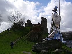
 Monument to Llewelyn ap Gruffydd Fychan | |
| Location | |
| Grid reference: | SN763346 |
| Location: | 51°59’39"N, 3°48’31"W |
| Data | |
| Population: | 2,870 (2001) |
| Post town: | Llandovery |
| Postcode: | SA20 |
| Dialling code: | 01550 |
| Local Government | |
| Council: | Carmarthenshire |
| Parliamentary constituency: |
Carmarthen East and Dinefwr |
Llandovery is a market town in Carmarthenshire, standing on the River Tywi and the A40 road.
The town is served by Llandovery railway station, where there is a park and ride to Llanelli and Shrewsbury by way of the Heart of Wales Line. Llandovery owes its name, which is usually held to mean 'church amongst the waters', to its position between the River Towy and the Afon Brân just upstream of their confluence. A smaller watercourse the Bawddwr, runs through and under the town.
History
Roman legacy
The Roman fort at Llanfair Hill to the north-east of the modern town around was known to the Romans as Alabum. It was built around AD 50 to 60 as part of their strategy for the conquest of the mountains of western Britain. A Roman road heads across Mynydd Bach Trecastell to the south-east of Llandovery bound for the fort of Brecon Gaer. Another heads down the Towy valley for Carmarthen whilst a third makes for the goldmines at Dolaugothi.
Norman and mediaeval castle
Attractions in the town include the remains of Llandovery Castle, built in 1110 and almost immediately captured by the Welsh, changing hands between Normans and Welsh until the reign of King Edward I. The castle was used by King Henry IV while on a sortie into Wales when he executed Llywelyn ap Gruffydd Fychan in the marketplace. It was later attacked by the forces of Owain Glyndŵr in 1403.
Llywelyn ap Gruffydd Fychan
A 16-foot-high stainless steel statue to Llywelyn ap Gruffydd Fychan was unveiled in 2001 on the north side of Llandovery Castle, overlooking the place of his execution six hundred years earlier. He had led the army of King Henry IV on 'a wild goose chase' under the pretence of leading them to a secret rebel camp and an ambush of Glyndŵr's forces. King Henry lost patience with him, exposed the charade and had him half hanged, disembowelled in front of his own eyes, beheaded and quartered - the quarters salted and dispatched to other Welsh towns for public display.
The statue won a national competition to choose a suitable design, the winner being that of Toby and Gideon Petersen, funding was from the National Lottery and the Arts Council of Wales.
Other attractions
Also in the town are a charity-run theatre (Llandovery Theatre), a heritage centre and Llandovery College. A tourist information and heritage centre is situated in the heart of the town. It houses exhibitions on the Tonn Press, the area's droving history and the nineteenth century geologist Sir Roderick Impey Murchison whose work in the area resulted in the name of Llandovery being assigned to rocks of a certain age across the entire world; the "Llandovery Epoch".
Many visitors use Llandovery as a touring base for the western part of the Brecon Beacons National Park which lies immediately to the south of the town. For others it is a stop en route to Pembrokeshire and Cardiganshire. Large numbers of motorcyclists congregate, particularly at weekends, in the West End cafe on Broad Street, part of the A40.
Llandovery is also the place where one of the first independent Welsh banks, The Black Ox, was established by a wealthy drover (later to become part of Lloyds TSB bank). The building is part of the King's Head inn which was the home of The Bank of the Black Ox.

Nearby places
The Dolaucothi Gold Mines are found 10 miles away near Pumpsaint on the A482, a road which follows the line of the original Roman road to Llanio fort.
Llandovery lies immediately to the north of Brecon Beacons National Park and Fforest Fawr Geopark, an area whose geological heritage is celebrated. These designated landscapes are centred on Bannau Sir Gâr or the Carmarthen Fans, themselves a part of the Black Mountain, an upland area which extends north towards the town as Mynydd Myddfai and Mynydd Bach Trecastell. The small village of Myddfai is located within the National Park, four miles to the south-east of Llandovery.
The Llyn Brianne dam is 11 miles to the north located in rugged and impressive countryside above Rhandir-mwyn. On the journey to the dam, visitors also pass the site of Twm Siôn Cati's Cave at the RSPB's Dinas reserve.