Berkshire: Difference between revisions
| (25 intermediate revisions by 5 users not shown) | |||
| Line 1: | Line 1: | ||
{{Infobox county | {{Infobox county | ||
|name=Berkshire | |name=Berkshire | ||
|map image= | |flag=Flag of Berkshire.svg | ||
|picture= | |map image=Berkshire Brit Isles Sect 5.svg | ||
|picture caption= | |picture=Abingdon Berks St Helens.jpg | ||
|picture caption=The River Thames at Abingdon,<br>looking towards St. Helen's parish church | |||
|area=722 square miles | |area=722 square miles | ||
|county town=[[ | |county town=[[Reading]] or [[Abingdon]] | ||
|biggest town=[[ | |biggest town=[[Reading]] | ||
}} | }} | ||
'''Berkshire''' is a [[Counties of the United Kingdom|Royal County]] in southern [[England]], lying along the south bank of the River [[Thames]]. It is usually regarded as one of the [[home counties]]. | |||
''' | The county's honorific prefix ''Royal'', which dates to the 19th century at least, is because of the presence of the royal residence of [[Windsor Castle]] in the county. This was recognised by the Queen in 1958, and letters patent were issued confirming it in 1974.<ref>{{cite web |url=http://www.berkshirerecordoffice.org.uk/collections/jubilee/jubilee_story4.htm |accessdate=2007-04-22 |title=Berkshire, The Royal County |author=Berkshire Record Office |work=Golden Jubilee 2002 collection}}</ref> | ||
Berkshire | Berkshire borders six other counties: [[Hampshire]] directly to the south; [[Surrey]] to the south-east; [[Wiltshire]] to the south-west; [[Oxfordshire]] and [[Buckinghamshire]], which lie to the north, across the Thames; and [[Gloucestershire]], with which Berkshire has a five-mile boundary at its north-western corner by [[Buscot]]. | ||
The county town was long considered to be [[Abingdon]], where the county's justices of the peace met, but in 1867 when the Summer assizes moved to [[Reading]], many have considered this to have moved the county town.<ref>Summer assizes were moved from Abingdon in 1867, effectively making Reading the county town. However, the Home Office informed the county's court of quarter sessions that in moving the court they had acted ''ultra vires'', and that they were required to petition the privy council to make the change. The petition was duly submitted and the change was officially approved with effect from the summer of 1869. {{cite news |title=Berkshire Quarter Sessions |author= |newspaper=Jackson's Oxford Journal |date=4 July 1868 |url= }}</ref> | |||
As part of a 2002 campaign, the plant conservation charity Plantlife chose the summer snowflake (the 'Loddon Lily') as the county flower. | |||
As part of a 2002 campaign, the plant conservation charity | |||
==Geography== | ==Geography== | ||
[[File:White horse from air.jpg|right|thumb|250px|The Uffington White Horse]] | |||
Berkshire lies entirely south of the River [[Thames]], which forms the county's northern boundary. Berkshire follows the Thames uninterruptedly for 103 miles from [[Buscot]] to [[Old Windsor]]. The riverbank is marked with numerous pretty towns and villages. | |||
[[ | Berkshire's landscape divides into two clearly distinct sections with the boundary lying roughly on a north-south line through the centre of [[Reading]]. | ||
Berkshire | In eastern Berkshire are several important tributaries of the Thames, including the [[River Loddon|Loddon]] and [[River Blackwater, Surrey|Blackwater]] which increase the amount of low-lying riverine land in the area. Beyond the flood plains, the land rises gently to the county boundaries with [[Surrey]] and [[Hampshire]]. Much of this area is still well wooded, especially around [[Bracknell]] and [[Windsor Great Park]]. | ||
Berkshire | In western Berkshire are two rich valleys separated by the [[Berkshire Downs]]. The Berkshire Downs are geologically an extension of the [[Chiltern Hills]], and force the Thames to turn sharply south until it forces its way between the Chilterns in [[Oxfordshire]] and the Berkshire Downs at the Goring Gap, a breach made apparently at the end of the last Ice Age. The Berkshire Downs are cut with small and well-wooded valleys draining into the [[River Lambourn]], [[River Pang]] and their tributaries, and open upland areas famous for their involvement in horse racing and training. | ||
To the north, between the Berkshire Downs and the Thames, is the [[Vale of White Horse]], named after the famous [[Uffington White Horse]]. The Vale is watered by numerous brooks which gradually join to make the [[River Ock]] a noble stream by the time it empties into the Thames at Abingdon. | |||
South of the Berkshire Downs runs the valley of the [[River Kennet]], which joins the Thames in Reading. Fairly steep slopes on each side delineate the river's flat floodplain. To the south, the land rises steeply to the boundary with [[Hampshire]], and here are found the highest parts of the county, the county top being [[Walbury Hill]] at 974 feet, which is also the highest point in south-east England. | |||
The county has two detached parts: the parish of [[Shilton, Oxfordshire|Shilton]], locally situate in Oxfordshire; and on the borders of Oxfordshire and Gloucestershire, the parishes of [[Little Faringdon]] and [[Langford, Oxfordshire|Langford]]. | |||
==Hundreds== | |||
The county is divided into 20 hundreds: | |||
{{div col|3}} | |||
*[[Beynhurst Hundred|Beynhurst]] | |||
*[[Bray Hundred|Bray]] | |||
*[[Charlton Hundred|Charlton]] | |||
*[[Compton Hundred|Compton]] | |||
*[[Cookham Hundred|Cookham]] | |||
*[[Faircross Hundred|Faircross]] | |||
*[[Faringdon Hundred|Faringdon]] | |||
*[[Ganfield]] | |||
*[[Hormer]] | |||
*[[Kintbury Eagle]] | |||
*[[Lambourn Hundred|Lambourn]] | |||
*[[Moreton Hundred|Moreton]] | |||
*[[Ock Hundred|Ock]] | |||
*[[Reading Hundred|Reading]] | |||
*[[Ripplesmere]] | |||
*[[Shrivenham Hundred|Shrivenham]] | |||
*[[Sonning Hundred|Sonning]] | |||
*[[Theale Hundred|Theale]] | |||
*[[Wantage Hundred|Wantage]] | |||
*[[Wargrave Hundred|Wargrave]] | |||
{{div col end}} | |||
==Major Towns== | ==Major Towns== | ||
[[File:Reading ayuntamiento.JPG|right|thumb| | [[File:Reading ayuntamiento.JPG|right|thumb|200px|Town Hall, Reading]] | ||
The largest towns in Berkshire by population are: | The largest towns in Berkshire by population are: | ||
| Line 45: | Line 70: | ||
* [[Faringdon]] | * [[Faringdon]] | ||
* [[Maidenhead]] | * [[Maidenhead]] | ||
* [[ | * [[Newbury]] | ||
* [[Reading | * [[Reading]] ''(partly in [[Oxfordshire]])'' | ||
* [[Sandhurst]] | * [[Sandhurst, Berkshire|Sandhurst]] | ||
* [[Thatcham]] | * [[Thatcham]] | ||
* [[Twyford, Berkshire|Twyford]] | * [[Twyford, Berkshire|Twyford]] | ||
| Line 54: | Line 79: | ||
* [[Windsor]] | * [[Windsor]] | ||
* [[Wokingham]] | * [[Wokingham]] | ||
Additionally the city of [[Oxford]], otherwise in [[Oxfordshire]], extends into Berkshire. | |||
==History== | ==History== | ||
[[File:Wenceslas Hollar - Berkshire (State 5).jpg|thumb|left|Detailed 17th-century map of Barkshire by Wenceslas Hollar]] | [[File:Wenceslas Hollar - Berkshire (State 5).jpg|thumb|left|200px|Detailed 17th-century map of Barkshire by Wenceslas Hollar]] | ||
The county is one of the oldest in England. It may date from the 840s, for in 848 King | The county is one of the oldest in England. It may date from the 840s, for in 848 King Cenwalh granted "three thousand hides by Ashdown" to Cuthred his kinsman.<ref>Anglo-Saxon Chronicle 848: ''Her Cenwalh gesalde Cuþrede his mæge .iii. þusendo londes be æscesdune''</ref> The county is first mentioned by name in 860. According to Asser, it takes its name from a large forest of box trees that was called ''Bearroc'' (believed, in turn, to be a British language word meaning "hilly").<ref>{{cite web|url=http://dictionary.reference.com/browse/berkshire|title=Dictionary.com|accessdate=2008-11-08}}</ref> | ||
Berkshire has been the scene of many battles throughout history, during | Berkshire has been the scene of many battles throughout history, during King Alfred the Great's campaign against the Danes, including the Battle of [[Englefield, Berkshire|Englefield]], the Battle of Ashdown and the Battle of Reading. | ||
During the | During the Civil War there were two battles in [[Newbury]]. During the Glorious Revolution of 1688, there was a second Battle of Reading, a skirmish also known as the "Battle of Broad Street", the only battle of the Glorious Revolution fought in England. | ||
Reading grew during the nineteenth century and in 1867 the county justices of the peace began to sit here.<ref>[http://www.berkshirehistory.com/villages/abingdon.html http://www.berkshirehistory.com/villages/abingdon.html] ''berkshirehistory.com''</ref> | Reading grew during the nineteenth century and in 1867 the county justices of the peace began to sit here.<ref>[http://www.berkshirehistory.com/villages/abingdon.html http://www.berkshirehistory.com/villages/abingdon.html] ''berkshirehistory.com''</ref> | ||
| Line 75: | Line 102: | ||
===Agricultural produce=== | ===Agricultural produce=== | ||
A number of distinctive cheeses are produced in Berkshire, including | A number of distinctive cheeses are produced in Berkshire, including Wigmore, Barkham blue and Waterloo cheeses. | ||
==Sport== | ==Sport== | ||
| Line 82: | Line 109: | ||
The London Irish rugby club also ground-share with Reading FC at the Madejski Stadium. | The London Irish rugby club also ground-share with Reading FC at the Madejski Stadium. | ||
== | == Places of interest == | ||
{{UKPlacesKey}} | |||
*{{i-Museum}} [[County Hall, Abingdon]] (Abingdon County Hall Museum)<ref>[http://www.abingdonmuseum.org.uk/ Abingdon County Hall Museum]</ref> Berkshire's 17th century County Hall | |||
{{ | *{{i-NTE}} [[Ashdown House]] – 17th century country house in the [[Berkshire Downs]] | ||
*{{i-NTE}} [[Basildon Park]] | |||
*[[Beale Park]] | |||
*{{i-OpenSpace}} [[Berkshire Downs]] | |||
*{{i-House}} [[Bisham Abbey]] | |||
*{{i-NTE}} [[Buscot Park]], [[Buscot]] – 18th century country house and landscape garden | |||
*{{i-Park}} California Country Park, [[Finchampstead]] | |||
*{{i-Museum}} Champs Chapel Museum of [[East Hendred]] | |||
*{{i-Railway}} [[Cholsey and Wallingford Railway]] | |||
*{{i-OpenSpace}} [[Combe Gibbet]] | |||
*{{i-Railway}} [[Didcot Railway Centre]] – museum of the Great Western Railway | |||
*{{i-EH}} [[Donnington Castle]] | |||
*{{i-House}} [[Frogmore|Frogmore House]] | |||
*{{i-NTE}} [[Great Coxwell Barn]] – 14th century Tithe barn | |||
*{{i-OpenSpace}} [[Greenham Common]] | |||
*{{i-NTE}} [[Lardon Chase]], [[the Holies]] and [[Lough Down]] | |||
*Legoland Windsor | |||
*{{i-MuseumNotFree}} Museum of English Rural Life | |||
*{{i-MuseumNotFree}} Museum of Reading | |||
*Reading Abbey | |||
*Reading School | |||
*{{i-OpenSpace}} [[North Wessex Downs]] Area of Outstanding Natural Beauty | |||
*{{i-MuseumNotFree}} REME Museum of Technology | |||
*{{i-OpenSpace}} [[The Ridgeway]] | |||
*{{i-OpenSpace}} Stanlake Park Wine Estate | |||
*{{i-OpenSpace}} [[Uffington White Horse]], [[Uffington Castle]] and [[Wayland's Smithy]] burial chamber in the Vale of the White Horse | |||
*{{i-House}} [http://www.miltonmanorhouse.com/ Milton Manor House] – 18th century country house | |||
*{{i-OpenSpace}} [[Walbury Hill]] ([[county top]] and hill fort) | |||
*{{i-MuseumNotFree}} Wallingford Museum | |||
*{{i-House}} [[Welford Park]] | |||
*{{i-Castle}} [[Windsor Castle]] | |||
*{{i-Park}} [[Windsor Great Park]] | |||
==See also== | |||
* [[ | *[[Flag of Berkshire]] | ||
==References== | ==References== | ||
{{Reflist}} | {{Reflist}} | ||
== | ==Outside links== | ||
* [http://www.berkshirehistory.com Royal Berkshire History] | *[http://www.berkshirehistory.com Royal Berkshire History] | ||
* [http://www.berkshireenclosure.org.uk Berkshire Enclosure Maps] Digital copies of Berkshire enclosure maps and awards 1738-1883 | *[http://www.berkshireenclosure.org.uk Berkshire Enclosure Maps] Digital copies of Berkshire enclosure maps and awards 1738-1883 | ||
*{{cite web | title = Victoria County History: Berkshire | publisher = British History Online | url = http://www.british-history.ac.uk/subject.aspx?subject=5&gid=2 | accessdate = 2009-07-13}} | *{{cite web | title = Victoria County History: Berkshire | publisher = British History Online | url = http://www.british-history.ac.uk/subject.aspx?subject=5&gid=2 | accessdate = 2009-07-13}} | ||
{{British county}} | {{British county}} | ||
Latest revision as of 22:24, 3 April 2021
| Berkshire United Kingdom | |
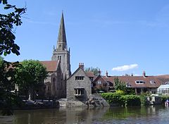
 The River Thames at Abingdon, looking towards St. Helen's parish church | |
|---|---|

| |
| Flag | |

| |
| [Interactive map] | |
| Area: | 722 square miles |
| Population: | 842,804 |
| County town: | Reading or Abingdon |
| Biggest town: | Reading |
| County flower: | Summer snowflake [1] |
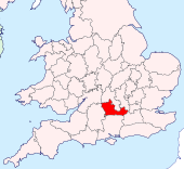
Berkshire is a Royal County in southern England, lying along the south bank of the River Thames. It is usually regarded as one of the home counties.
The county's honorific prefix Royal, which dates to the 19th century at least, is because of the presence of the royal residence of Windsor Castle in the county. This was recognised by the Queen in 1958, and letters patent were issued confirming it in 1974.[1]
Berkshire borders six other counties: Hampshire directly to the south; Surrey to the south-east; Wiltshire to the south-west; Oxfordshire and Buckinghamshire, which lie to the north, across the Thames; and Gloucestershire, with which Berkshire has a five-mile boundary at its north-western corner by Buscot.
The county town was long considered to be Abingdon, where the county's justices of the peace met, but in 1867 when the Summer assizes moved to Reading, many have considered this to have moved the county town.[2]
As part of a 2002 campaign, the plant conservation charity Plantlife chose the summer snowflake (the 'Loddon Lily') as the county flower.
Geography

Berkshire lies entirely south of the River Thames, which forms the county's northern boundary. Berkshire follows the Thames uninterruptedly for 103 miles from Buscot to Old Windsor. The riverbank is marked with numerous pretty towns and villages.
Berkshire's landscape divides into two clearly distinct sections with the boundary lying roughly on a north-south line through the centre of Reading.
In eastern Berkshire are several important tributaries of the Thames, including the Loddon and Blackwater which increase the amount of low-lying riverine land in the area. Beyond the flood plains, the land rises gently to the county boundaries with Surrey and Hampshire. Much of this area is still well wooded, especially around Bracknell and Windsor Great Park.
In western Berkshire are two rich valleys separated by the Berkshire Downs. The Berkshire Downs are geologically an extension of the Chiltern Hills, and force the Thames to turn sharply south until it forces its way between the Chilterns in Oxfordshire and the Berkshire Downs at the Goring Gap, a breach made apparently at the end of the last Ice Age. The Berkshire Downs are cut with small and well-wooded valleys draining into the River Lambourn, River Pang and their tributaries, and open upland areas famous for their involvement in horse racing and training.
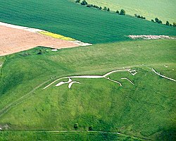
To the north, between the Berkshire Downs and the Thames, is the Vale of White Horse, named after the famous Uffington White Horse. The Vale is watered by numerous brooks which gradually join to make the River Ock a noble stream by the time it empties into the Thames at Abingdon.
South of the Berkshire Downs runs the valley of the River Kennet, which joins the Thames in Reading. Fairly steep slopes on each side delineate the river's flat floodplain. To the south, the land rises steeply to the boundary with Hampshire, and here are found the highest parts of the county, the county top being Walbury Hill at 974 feet, which is also the highest point in south-east England.
The county has two detached parts: the parish of Shilton, locally situate in Oxfordshire; and on the borders of Oxfordshire and Gloucestershire, the parishes of Little Faringdon and Langford.
Hundreds
The county is divided into 20 hundreds:
Major Towns

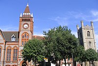
The largest towns in Berkshire by population are:
- Abingdon
- Ascot
- Bracknell
- Didcot
- Faringdon
- Maidenhead
- Newbury
- Reading (partly in Oxfordshire)
- Sandhurst
- Thatcham
- Twyford
- Wallingford
- Wantage
- Windsor
- Wokingham
Additionally the city of Oxford, otherwise in Oxfordshire, extends into Berkshire.
History

The county is one of the oldest in England. It may date from the 840s, for in 848 King Cenwalh granted "three thousand hides by Ashdown" to Cuthred his kinsman.[3] The county is first mentioned by name in 860. According to Asser, it takes its name from a large forest of box trees that was called Bearroc (believed, in turn, to be a British language word meaning "hilly").[4]
Berkshire has been the scene of many battles throughout history, during King Alfred the Great's campaign against the Danes, including the Battle of Englefield, the Battle of Ashdown and the Battle of Reading.
During the Civil War there were two battles in Newbury. During the Glorious Revolution of 1688, there was a second Battle of Reading, a skirmish also known as the "Battle of Broad Street", the only battle of the Glorious Revolution fought in England.
Reading grew during the nineteenth century and in 1867 the county justices of the peace began to sit here.[5]
In the twentieth century Berkshire was at the forefront of new technology; the first nuclear power station was built at Harwell and toward the end of the century new computer industries began to congregate around Bracknell and Reading, where they remain dominant industries.
Economy
Information technology
The information technology industry is concentrated in eastern Berkshire, in particular in and around Reading, Bracknell and Wokingham.
Agricultural produce
A number of distinctive cheeses are produced in Berkshire, including Wigmore, Barkham blue and Waterloo cheeses.
Sport
One football club from the county plays professional football; Reading FC, who were formed in 1871.
The London Irish rugby club also ground-share with Reading FC at the Madejski Stadium.
Places of interest
| Key | |
| Cathedral/Abbey/Priory | |
| Accessible open space | |
| Amusement/Theme Park | |
| Castle | |
| Country Park | |
| English Heritage | |
| Forestry Commission | |
| Heritage railway | |
| Historic House | |
| Museum (free/not free) | |
| National Trust | |
| Zoo | |
 County Hall, Abingdon (Abingdon County Hall Museum)[6] Berkshire's 17th century County Hall
 Ashdown House – 17th century country house in the Berkshire Downs
 Basildon Park
- Beale Park
 Berkshire Downs
 Bisham Abbey
 Buscot Park, Buscot – 18th century country house and landscape garden
 California Country Park, Finchampstead
 Champs Chapel Museum of East Hendred
 Cholsey and Wallingford Railway
 Combe Gibbet
 Didcot Railway Centre – museum of the Great Western Railway
 Donnington Castle
 Frogmore House
 Great Coxwell Barn – 14th century Tithe barn
 Greenham Common
 Lardon Chase, the Holies and Lough Down
- Legoland Windsor
 Museum of English Rural Life
 Museum of Reading
- Reading Abbey
- Reading School
 North Wessex Downs Area of Outstanding Natural Beauty
 REME Museum of Technology
 The Ridgeway
 Stanlake Park Wine Estate
 Uffington White Horse, Uffington Castle and Wayland's Smithy burial chamber in the Vale of the White Horse
 Milton Manor House – 18th century country house
 Walbury Hill (county top and hill fort)
 Wallingford Museum
 Welford Park
 Windsor Castle
 Windsor Great Park
See also
References
- ↑ Berkshire Record Office. "Berkshire, The Royal County". Golden Jubilee 2002 collection. http://www.berkshirerecordoffice.org.uk/collections/jubilee/jubilee_story4.htm. Retrieved 2007-04-22.
- ↑ Summer assizes were moved from Abingdon in 1867, effectively making Reading the county town. However, the Home Office informed the county's court of quarter sessions that in moving the court they had acted ultra vires, and that they were required to petition the privy council to make the change. The petition was duly submitted and the change was officially approved with effect from the summer of 1869. "Berkshire Quarter Sessions". Jackson's Oxford Journal. 4 July 1868.
- ↑ Anglo-Saxon Chronicle 848: Her Cenwalh gesalde Cuþrede his mæge .iii. þusendo londes be æscesdune
- ↑ "Dictionary.com". http://dictionary.reference.com/browse/berkshire. Retrieved 2008-11-08.
- ↑ http://www.berkshirehistory.com/villages/abingdon.html berkshirehistory.com
- ↑ Abingdon County Hall Museum
Outside links
- Royal Berkshire History
- Berkshire Enclosure Maps Digital copies of Berkshire enclosure maps and awards 1738-1883
- "Victoria County History: Berkshire". British History Online. http://www.british-history.ac.uk/subject.aspx?subject=5&gid=2. Retrieved 2009-07-13.
| Counties of the United Kingdom |
|---|
|
Aberdeen • Anglesey • Angus • Antrim • Argyll • Armagh • Ayr • Banff • Bedford • Berks • Berwick • Brecknock • Buckingham • Bute • Caernarfon • Caithness • Cambridge • Cardigan • Carmarthen • Chester • Clackmannan • Cornwall • Cromarty • Cumberland • Denbigh • Derby • Devon • Dorset • Down • Dumfries • Dunbarton • Durham • East Lothian • Essex • Fermanagh • Fife • Flint • Glamorgan • Gloucester • Hants • Hereford • Hertford • Huntingdon • Inverness • Kent • Kincardine • Kinross • Kirkcudbright • Lanark • Lancaster • Leicester • Lincoln • Londonderry • Merioneth • Middlesex • Midlothian • Monmouth • Montgomery • Moray • Nairn • Norfolk • Northampton • Northumberland • Nottingham • Orkney • Oxford • Peebles • Pembroke • Perth • Radnor • Renfrew • Ross • Roxburgh • Rutland • Selkirk • Shetland • Salop • Somerset • Stafford • Stirling • Suffolk • Surrey • Sussex • Sutherland • Tyrone • Warwick • West Lothian • Westmorland • Wigtown • Wilts • Worcester • York |