Maidenhead
| Maidenhead | |
| Berkshire | |
|---|---|
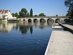
 Maidenhead on the River Thames | |
| Location | |
| Grid reference: | SU889811 |
| Location: | 51°31’18"N, -0°43’4"W |
| Data | |
| Population: | 58,848 (2001) |
| Post town: | Maidenhead |
| Postcode: | SL6 |
| Dialling code: | 01628 |
| Local Government | |
| Council: | Windsor and Maidenhead |
| Parliamentary constituency: |
Maidenhead |
Maidenhead is a prosperous town in eastern Berkshire, standing on the south bank of the River Thames.
Maidenhead is in England's 'Silicon Corridor' along the M4 motorway west of London. Maidenhead's industries include computer software, plastics, pharmaceuticals, printing and telecommunications. Many Maidenhead residents commute to work in London, or to the towns of Slough (Buckinghamshire) and Reading.
It has been calculated that average house prices in Maidenhead are amongst the highest in Britain.


History
Maidenhead's name refers to the busy riverside area where the 'New wharf' or 'Maiden Hythe' was built, perhaps as early as Anglo-Saxon times. Another speculation is that the nearby Great Hill of Taplow was called the 'Mai Dun' by the Iron Age Britons, though there is no evidence of any such name.
The area of the town centre was originally known as 'South Ellington' and is recorded in the Domesday Book as Ellington in the hundred of Beynhurst.
In 1280, a bridge was erected across the river to replace a ferry in what was then the hamlet of South Ellington.[1] The Great West Road to Reading, Gloucester and Bristol was diverted over the new bridge - previously it kept to the north bank crossed the Thames by ford at Cookham - and mediæval Maidenhead grew up around it.[2] Within a few years a wharf was constructed next to the bridge and the South Ellington name was dropped with the area becoming known as Maidenhythe. The earliest record of this name change is in the Bray Court manorial rolls of 1296.[1] The bridge led to the growth of Maidenhead: a stopping point for coaches on the journeys between London and Bath and the High Street became populated with inns. The current Maidenhead Bridge, a local landmark, dates from 1777 and was built at a cost of £19,000.

King Charles I met his children for the last time before his execution in 1649 at the Greyhound Inn[3] on the High Street, the site of which is now a branch of the National Westminster Bank: a plaque commemorates their meeting.
When the Great Western Railway came to the town, it began to expand. Muddy roads were replaced and public services were installed. The High Street began to change again and substantial Victorian red brick architecture began to appear throughout the town. Maidenhead became its own entity in 1894, being split from the civil parishes of both Bray and Cookham.
Maidenhead Citadel Corps of the Salvation Army was first opened in the Town in the mid 1880s. Maidenhead Citadel Band was soon founded in 1886 by Bandmaster William Thomas who later became Mayor of the Town.
By Edwardian times, Boulter's Lock nearby became a favoured resort especially on Ascot Sunday, and the Skindles Hotel developed a reputation for illicit liaisons.[4]
References
- ↑ 1.0 1.1 Phillips, Geoffrey (1981). Thames Crossings. David and Charles. ISBN 0715382020.
- ↑ Higham, Roger (1977). Berkshire and the Vale of the White Horse. London: Batsford.
- ↑ William Godwin History of the Commonwealth of England: To the death of Charles I H. Colburn, 1826
- ↑ Paul Goldsack River Thames:In the Footsteps of the Famous English Heritage/Bradt 2003
Outside links
- All Saints Church, Boyne Hill, Maidenhead
- Maidenhead Citadel Band of The Salvation Army
- Community website and business directory
- RBWM Maidenhead Town Partnership
- Windsor and Maidenhead Conservation Volunteers
- Maidenhead Rowing Club
- Maidenhead Sailing Club
- Maidenhead Waterways Restoration Group
- Maidenhead Advertiser Newspaper
- Maidenhead Scouts
- Maidenhead Archers
- Maidenhead Sea Cadets
- Maidenhead Revolution Football Club
- Maidenhead Online
- Maidenhead Chamber of Commerce
- Maidenhead Civic Society