Aberdeenshire: Difference between revisions
No edit summary |
mNo edit summary |
||
| Line 40: | Line 40: | ||
The rivers abound with salmon and trout, and the pearl mussel occurs in the Ythan and Don. A valuable pearl in the Scottish crown is said to be from the Ythan. [[Loch Muick]], the largest of the few lakes in the county, 1,310 ft above the sea, 2½ miles long and ⅓ to ½ miles broad, lies some 8½ miles southwest of [[Ballater]], and has [[Altnagiuthasach]], a royal shooting-box, near its south-western end. [[Loch Strathbeg]], 6 miles southeast of Fraserburgh, is only separated from the sea by a narrow strip of land. There are noted [[chalybeate]] springs at Peterhead, Fraserburgh, and [[Pannanich]] near [[Ballater]]. | The rivers abound with salmon and trout, and the pearl mussel occurs in the Ythan and Don. A valuable pearl in the Scottish crown is said to be from the Ythan. [[Loch Muick]], the largest of the few lakes in the county, 1,310 ft above the sea, 2½ miles long and ⅓ to ½ miles broad, lies some 8½ miles southwest of [[Ballater]], and has [[Altnagiuthasach]], a royal shooting-box, near its south-western end. [[Loch Strathbeg]], 6 miles southeast of Fraserburgh, is only separated from the sea by a narrow strip of land. There are noted [[chalybeate]] springs at Peterhead, Fraserburgh, and [[Pannanich]] near [[Ballater]]. | ||
==Cities | ===Cities=== | ||
*[[Aberdeen]] | *[[Aberdeen]] | ||
===Towns and villages=== | |||
*[[Ellon]] | *[[Ellon]] | ||
*[[Fraserburgh]] | *[[Fraserburgh]] | ||
| Line 49: | Line 51: | ||
*[[Turriff]] | *[[Turriff]] | ||
==Parishes== | ===Parishes=== | ||
{{parishliststart}} | {{parishliststart}} | ||
*[[Aberdeen]] | *[[Aberdeen]] | ||
Revision as of 12:13, 25 August 2010
| Aberdeenshire United Kingdom | |
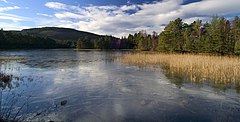
 The Queen's Loch | |
|---|---|

| |
| Flag | |

| |
| [Interactive map] | |
| Area: | 1,950 square miles |
| Population: | Template:Hcspop |
| County town: | Aberdeen |
| County flower: | Bearberry [1] |
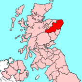
Aberdeenshire is a shire in the Highlands of Scotland.
The county borders Kincardineshire, Angus and Perthshire to the south, Inverness-shire and Banffshire to the west, and the North Sea to the north and east. It has a coast-line of 65 miles.
Geography
Popular geography divides the traditional shire into five districts:
- Mar, mostly between the Dee and Don, which nearly covers the southern half of the county and contains the city of Aberdeen. It is mountainous, especially Braemar, which contains the greatest mass of elevated land in the British Isles. The Dee valley has sandy soil, the Don valley loamy.
- Formartine, between the lower Don and Ythan, has a sandy coast, which is succeeded inland by a clayey, fertile, tilled tract, and then by low hills, moors, mosses and tilled land.
- Buchan lies north of the Ythan, and comprising the north-east of the county, is next in size to Mar, parts of the coast being bold and rocky, the interior bare, low, flat, undulating and in places peaty. On the coast, six miles (10 km) south of Peterhead, are the Bullers of Buchan – a basin in which the sea, entering by a natural arch, boils up violently in stormy weather. Buchan Ness is the most easterly point of Scotland.
- Garioch, in the centre of the shire, comprises a beautiful, undulating, loamy, fertile valley, formerly called the granary of Aberdeen.
- Strathbogie, occupying a considerable area south of the Deveron, mostly consists of hills, moors and mosses.
The mountains provide the most striking of the physical features of the county.
- Ben Macdhui, 4,296 ft, a magnificent mass, the second-highest mountain in the United Kingdom,
- Braeriach 4,248 ft
- Cairn Toul, 4,241 ft
- Beinn a' Bhùird, 3,924 ft
- Ben Avon, 3,843 ft
- "Dark" Lochnagar, 3,786 ft, the subject of a well-known song by Byron,
- Cairn Eas, 3,556 ft
- Sgarsoch, 3,402 ft
- Culardoch, 2,953 ft
are the principal heights in the division of Mar
Farther north rise the Buck of Cabrach, 2,368 ft on the Banffshire border, Tap o' Noth, 1,830 ft, Bennachie, 1,698 ft, a beautiful peak which from its central position is a landmark visible from many different parts of the county, and which is celebrated in John Imlah's song, O gin I war faur the Gadie rins, and Foudland, 1,529 ft.

The chief rivers are the Dee, 90 miles long; the Don, 82 miles; the Ythan, 37 miles, with mussel-beds at its mouth; the Ugie, 20 miles, and the Deveron, 62 miles, partly on the boundary of Banffshire.
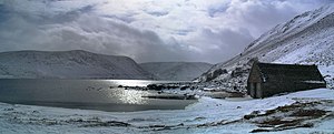
The rivers abound with salmon and trout, and the pearl mussel occurs in the Ythan and Don. A valuable pearl in the Scottish crown is said to be from the Ythan. Loch Muick, the largest of the few lakes in the county, 1,310 ft above the sea, 2½ miles long and ⅓ to ½ miles broad, lies some 8½ miles southwest of Ballater, and has Altnagiuthasach, a royal shooting-box, near its south-western end. Loch Strathbeg, 6 miles southeast of Fraserburgh, is only separated from the sea by a narrow strip of land. There are noted chalybeate springs at Peterhead, Fraserburgh, and Pannanich near Ballater.
Cities
Towns and villages
Parishes
- Aberdeen
- Aberdour
- Aboyne and Glen Tanar
- Alford
- Auchindoir and Kearn
- Auchterless
- Belhelvie
- Birse
- Bourtie
- Cairnie
- Chapel of Garioch
- Clatt
- Cluny
- Coull
- Crathie and Braemar
- Crimond
- Cruden
- Culsalmond
- Daviot
- Drumblade
- Drumoak
- Dyce
- Echt
- Ellon
- Fintray
- Forgue
- Foveran
- Fraserburgh
- Fyvie
- Gartly
- Glass
- Glenbuchat
- Glenmuick, Tullich and Glengairn
- Huntly
- Insch
- Inverurie
- Keig
- Keithhall and Kinkell
- Kemnay
- Kennethmont
- Kildrummy
- Kincardine O'Neil
- Kinellar
- King Edward
- Kintore
- Leochel-Cushnie
- Leslie
- Logie Buchan
- Logie-Coldstone
- Longside
- Lonmay
- Lumphanan
- Meldrum
- Methlick
- Midmar
- Monquhitter
- Monymusk
- New Deer
- Newhills
- New Machar
- Old Deer
- Old Machar
- Oyne
- Peterculter
- Peterhead
- Pitsligo
- Premnay
- Rathen
- Rayne
- Rhynie
- Skene
- Slains
- St Fergus
- Strathdon
- Strichen
- Tarland
- Tarves
- Tough
- Towie
- Tullynessle and Forbes
- Tundergarth
- Turriff
- Tyrie
- Udny
This county article is a stub: help to improve Wikishire by building it up.
| Counties of the United Kingdom |
|---|
|
Aberdeen • Anglesey • Angus • Antrim • Argyll • Armagh • Ayr • Banff • Bedford • Berks • Berwick • Brecknock • Buckingham • Bute • Caernarfon • Caithness • Cambridge • Cardigan • Carmarthen • Chester • Clackmannan • Cornwall • Cromarty • Cumberland • Denbigh • Derby • Devon • Dorset • Down • Dumfries • Dunbarton • Durham • East Lothian • Essex • Fermanagh • Fife • Flint • Glamorgan • Gloucester • Hants • Hereford • Hertford • Huntingdon • Inverness • Kent • Kincardine • Kinross • Kirkcudbright • Lanark • Lancaster • Leicester • Lincoln • Londonderry • Merioneth • Middlesex • Midlothian • Monmouth • Montgomery • Moray • Nairn • Norfolk • Northampton • Northumberland • Nottingham • Orkney • Oxford • Peebles • Pembroke • Perth • Radnor • Renfrew • Ross • Roxburgh • Rutland • Selkirk • Shetland • Salop • Somerset • Stafford • Stirling • Suffolk • Surrey • Sussex • Sutherland • Tyrone • Warwick • West Lothian • Westmorland • Wigtown • Wilts • Worcester • York |