Bennachie

Bennachie is a massif in Aberdeenshire containing several fine hills.[1] Its name is from the Gaelic Beinn na Cìche, meaning "Hill of the breast", which name is reflected in its best known peak, Mither Tap.
The highest mountain of the range is Oxen Craig, which reaches a height of 1733 feet; not particularly high compared with other peaks in Aberdeenshire, but prominent against the sky, owing to its isolation and the relative flatness of the surrounding terrain, and dominates the skyline from several viewpoints.
Mither Tap, which reaches 1,699 feet and it crowned with an Iron Age hill fort.
Most of the tops of Bennachie lie along an east / west ridge, with the exception of Millstone Hill (1,342 feet) an outlier or spur which is separated from and to the south of the main ridge. Mither Tap Bennachie is visible from a number of distant points; to the north it is visible from Longman Hill, a point considerably to the north.[2]
History
Bronze Age standing stones are in the surrounding area. It has been suggested as a possible site of the battle of Mons Graupius described by Tacitus. An alternative Gaelic etymology of the name Bennachie is suggested as *Beinn a' Chath, meaning 'hill of the battle', though it seems a wild appear to romance, as Gaelic was not spoken in these hills for several centuries after Mons Graupius.
From 1800 to 1859 common land on the east side of Bennachie was home to a community of squatters known locally as the Colony.[3] A small number of families led a Crofting life often doing skilled work, such as dyking and quarrying, for local landowners. After 1859 the Colony dwindled as the common land was broken up and divided amongst the local estates. However, the last of the original colonists, George Esson, lived on the hill until his death in the 1930s. Visitors to Bennachie can explore the remains of the Colony and extensive work is being done on site and amongst local parish records to determine the history of the Colonists.
Paths and environment
The range of hills is a popular destination for walkers since it is relatively close to Aberdeen. The Gordon Way is a waymarked trail that traverses the Southern flank of Bennachie between the Visitors Centre in the East and Suie Car Park to the West. Most of the Bennachie range is owned by the Forestry Commission, who maintain a network of paths on and around the hills, several car parks and a visitor centre which is located at the eastern foot of the range. A volunteer group, the Bailies of Bennachie, founded in 1973, helps with this work and with other environmental and archaeological activities on the hill.[4]There are several marked paths, including fairly easy ascents of Oxen Craig and Mither Tap that start from the centre.
Pictures

-
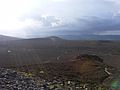 Oxen Craig from Mither Tap
 -
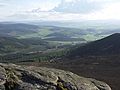
 View north from Mither Tap
 -
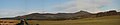 Bennachie viewed from the South, with the peak of Mither Tap to the right.
 -
 View from the summit of Mither Tap


Outside links
| ("Wikimedia Commons" has material about Bennachie) |
- Computer-generated virtual panoramas:
- Baillies of Bennachie: a Bennachie Voluntary Conservation Society
References
- ↑ Whiteley, A.W.M. (Ed.) (1976). The Book of Bennachie. The Bailies of Bennachie. ISBN 0-900323-21-3
- ↑ Michael Hogan, C. "Longman Hill", Longman Hill, 2008, Modern Antiquarian
- ↑ Fagen, J. "Echoes of the Bennachie Colonists", Leopard Magazine, Retrieved on 2009-08-11
- ↑ "2013 Newsletter". Bailies of Bennachie Newsletter. 2013.