Roxburghshire: Difference between revisions
More material |
|||
| (13 intermediate revisions by 3 users not shown) | |||
| Line 1: | Line 1: | ||
{{Infobox county | {{Infobox county | ||
|name=Roxburghshire | |name=Roxburghshire | ||
|map image= | |map image=Roxburghshire Brit Isles Sect 2.svg | ||
|picture="Primsidehill - geograph.org.uk - 91774.jpg | |picture="Primsidehill - geograph.org.uk - 91774.jpg | ||
|picture caption=Primsidehill | |picture caption=Primsidehill | ||
|county town=[[Jedburgh]] | |county town=[[Jedburgh]] | ||
}} | }} | ||
The '''County of Roxburgh''' is an inland [[Counties of the United Kingdom|shire]]; the middlemost of the [[Middle Shires]] it looks both west and east. Historically it was a lawless place between north and south, the victim of the | The '''County of Roxburgh''' is an inland [[Counties of the United Kingdom|shire]]; the middlemost of the [[Middle Shires]] it looks both west and east. Historically it was a lawless place between north and south, the victim of the mediæval border wars and the dark heart of reiver country. Today it is somewhat quieter and enjoyed for the scenery of its hills and dales. | ||
To the west of Roxburghshire is [[Dumfriesshire]] and to the | To the west of Roxburghshire is [[Dumfriesshire]] and to the south-west [[Cumberland]]. To the north-east are [[Berwickshire]] and [[Selkirkshire]] and to the south and south-east is [[Northumberland]]. The shire was named after the Royal Burgh of [[Roxburgh]] on the Tweed, but the old town was destroyed repeatedly in the border wars of the Middle Ages and after the final fall of [[Berwick upon Tweed|Berwick]] in 1460 it was abandoned. | ||
==The lie of the land== | ==The lie of the land== | ||
| Line 24: | Line 22: | ||
===Hills=== | ===Hills=== | ||
[[File:Peel Fell - geograph.org.uk - 570301.jpg|right|thumb|200px|Peel Fell]] | [[File:Peel Fell - geograph.org.uk - 570301.jpg|right|thumb|200px|Peel Fell]] | ||
The [[Cheviots]] stretch through Roxburghshire and [[Northumberland]] and their highest ridges mark much of the | The [[Cheviots]] stretch through Roxburghshire and [[Northumberland]] and their highest ridges mark much of the border between the two counties, Roxburghshire's own [[county top]] being [[Auchope Cairn]], a subsidiary summit of [[Cairn Hill, Northumberland|Cairn Hill]], on the Northumberland border and on the flank of [[The Cheviot]] itself. | ||
The Cheviot hills of Roxburghshire include: | The Cheviot hills of Roxburghshire include: | ||
*Catcleuch Shin (1,742 feet) | *Catcleuch Shin (1,742 feet) | ||
*Peel Fell (1,964 feet) | *[[Peel Fell]] (1,964 feet) | ||
The hills form the watershed between the east coast and the west coast, [[Teviotdale]] running east and [[Liddesdale]] running west, including: | The hills form the watershed between the east coast and the west coast, [[Teviotdale]] running east and [[Liddesdale]] running west, including: | ||
| Line 34: | Line 32: | ||
*Greatmoor (1,964 feet) | *Greatmoor (1,964 feet) | ||
*[[Pennygant]] (1,805 feet) | *[[Pennygant]] (1,805 feet) | ||
*Din Fell (1,735 feet) | *[[Din Fell]] (1,735 feet) | ||
* | *[[Wyndburgh Hill]] (1,622 feet) | ||
*Arnton Fell (1,464 feet). | *[[Arnton Fell]] (1,464 feet). | ||
===Rivers and lakes=== | ===Rivers and lakes=== | ||
[[File:River Teviot.JPG|right|thumb|200px|The Teviot]] | [[File:River Teviot.JPG|right|thumb|200px|The Teviot]] | ||
The largest river in the county is the [[River Tweed|Tweed]], which enters Roxburghshire in the north, from Selkirkshire, and flows through the north of Roxburghshire for 26 miles; more than a third of the river's whole length, serving as a | The largest river in the county is the [[River Tweed|Tweed]], which enters Roxburghshire in the north, from Selkirkshire, and flows through the north of Roxburghshire for 26 miles; more than a third of the river's whole length, serving as a border river for some twelve miles at either end of this reach. | ||
The Tweed is met by the Bowden and the Teviot, the Allan and the Eden. | The Tweed is met by the Bowden and the Teviot, the Allan and the Eden. | ||
The [[River Teviot]] carves Teviotdale and is entirely within Roxburghshire. It rises in near Causeway Grain Head on the Dumfriesshire border and runs | The [[River Teviot]] carves Teviotdale and is entirely within Roxburghshire. It rises in near Causeway Grain Head on the Dumfriesshire border and runs in a north-easterly direction for 37 miles until it sheds its waters into the growing Tweed at [[Kelso]]. To the Teviot flow many lesser rivers and burns, including the Allan Water, the Slitrig, Dean Burn, the Rule, the Jed, the Oxnam and the Kale, and, on the left, Borthwick Water and the Ale. | ||
In the south of Roburghshire is the [[River Liddel]], which forms Liddesdale. The Liddle rises near Peel Fell in the Cheviots and flows | In the south of Roburghshire is the [[River Liddel]], which forms Liddesdale. The Liddle rises near Peel Fell in the Cheviots and flows south-west to the [[River Esk, Cumberland|River Esk]] for 27 miles. With its tributary, the Kershope, the Liddel forms the border with Cumberland for some miles. | ||
The lakes are few and small, the largest being Yetholm or Primside Loch and Horselaw, both in the parish of Linton among outlying hills of the Cheviots. Teviotdale, Liddesdale, Tweedside and Jedvale are the main valleys. | The lakes are few and small, the largest being Yetholm or Primside Loch and Horselaw, both in the parish of Linton among outlying hills of the Cheviots. Teviotdale, Liddesdale, Tweedside and Jedvale are the main valleys. | ||
==History== | ==History== | ||
The lands which became Roxburghshire belonged to Northumbria until the tenth or early eleventh century, when the lands north of the Tweed were ceded to the King of Scots. | The lands which became Roxburghshire belonged to [[Northumbria]] until the tenth or early eleventh century, when the lands north of the Tweed were ceded to the King of Scots. It was made shire ground by King Alexander I during his short reign in the early part of the twelfth century. | ||
Melrose | [[Melrose Abbey]] had been established in the Anglo-Saxon period and was a noted seat of learning about which Bede wrote. In the twelfth century King David I founded the Abbeys at [[Jedburgh Abbey|Jedburgh]], [[Dryburgh Abbey|Dryburgh]] and [[Kelso Abbey|Kelso]] in his sweep of new monastic foundations, and Jedburgh in particular became a wealthy centre until the Reformation. The shire's main fortification, Roxburgh, was less fortunate; fought over repeatedly during the Middle Ages during which it was mainly held by the English, until the castle and town were finally captured for the Scots and destroyed by King James II. | ||
In later centuries Roxburghshire became | In later centuries Roxburghshire became Reiver country. The border robbers on each side of the border were cruel and ruthless, none more so than the men of Liddesdale. However, after the accession of King James VI to the English throne, the forces of law could be applied without regard to borders and these lands were brought to peace. | ||
==Towns and villages== | ==Towns and villages== | ||
| Line 71: | Line 69: | ||
{{parishliststart}} | {{parishliststart}} | ||
*[[Ancrum]] | *[[Ancrum]] | ||
*[[Ashkirk]]<sup>†</sup> | |||
*[[Bedrule]] | *[[Bedrule]] | ||
*[[Bowden]] | *[[Bowden]] | ||
*[[Castleton]] | *[[Castleton, Roxburghshire|Castleton]] | ||
*[[Cavers]] | *[[Cavers]] | ||
*[[Crailing]] | *[[Crailing]] | ||
| Line 84: | Line 83: | ||
*[[Kelso]] | *[[Kelso]] | ||
*[[Lilliesleaf]] | *[[Lilliesleaf]] | ||
*[[Linton]] | *[[Linton, Roxburghshire|Linton]] | ||
*[[Makerstoun]] | *[[Makerstoun]] | ||
*[[Maxton]] | *[[Maxton]] | ||
*[[Melrose]] | *[[Melrose]]<sup>‡</sup> | ||
*[[Minto]] | *[[Minto]] | ||
*[[Morebattle]] | *[[Morebattle]] | ||
*[[Oxnam]] | *[[Oxnam]] | ||
*[[Roberton]] | *[[Roberton]]<sup>†</sup> | ||
*[[Roxburgh]] | *[[Roxburgh]] | ||
*[[Smailholm]] | *[[Smailholm]] | ||
| Line 101: | Line 100: | ||
*[[Yetholm]] | *[[Yetholm]] | ||
{{parishlistend}} | {{parishlistend}} | ||
†: Extends into Selkirkshire.<br /> | |||
‡: The civil parish of Melrose extends into Berwickshire. The 1,302 acres in question additionally form a detached part of the ancient parish of [[Lauder]].<br /> | |||
Additionally parts of the parishes of [[Selkirk]] and [[Galashiels]] otherwise in Selkirkshire extend into Roxburghshire. | |||
==Things to see in Roxburghshire== | ==Things to see in Roxburghshire== | ||
| Line 107: | Line 109: | ||
*[[Cheviot Hills]] | *[[Cheviot Hills]] | ||
*Cessford Burn | *Cessford Burn | ||
*Floors Castle | *[[Floors Castle]] | ||
*{{i-NTS}} Harmony Garden | *{{i-NTS}} [[Harmony Garden]] | ||
*{{i-Castle}} Hermitage Castle | *{{i-Castle}} [[Hermitage Castle]] | ||
*{{i-Abbey}}{{i-HS}} [[Jedburgh]] | *{{i-Abbey}}{{i-HS}} [[Jedburgh Abbey]] | ||
*{{i-Abbey}} [[Kelso]] | *{{i-Abbey}} [[Kelso Abbey]] | ||
*{{i-House}} Mellerstain House | *{{i-House}} [[Mellerstain House]] | ||
*{{i-Abbey}}{{i-HS}} [[Melrose]] | *{{i-Abbey}}{{i-HS}} [[Melrose Abbey]] | ||
*{{i-House}} Monteviot | *{{i-House}} [[Monteviot House]] | ||
*{{i-NTS}} Priorwood Garden | *{{i-NTS}} [[Priorwood Garden]] | ||
*[[Scots' Dike]] | *[[Scots' Dike]] | ||
*{{i-HS}} Smailholm Tower | *{{i-HS}} [[Smailholm Tower]] | ||
*Southern Upland Way | *[[Southern Upland Way]] | ||
*[[Teviotdale]] | *[[Teviotdale]] | ||
*Trimontium (Newstead) Roman fort | *[[Trimontium]] (Newstead) Roman fort | ||
*Waterloo Monument, [[Ancrum]] | *Waterloo Monument, [[Ancrum]] | ||
==Books== | ==Books== | ||
*Jeffrey, Alexander: ''The History and Antiquities of Roxburghshire'' (Edinburgh, | *Jeffrey, Alexander: ''The History and Antiquities of Roxburghshire'' (Edinburgh, 1857–64) | ||
{{British county}} | {{British county}} | ||
Latest revision as of 07:52, 13 May 2022
| Roxburghshire United Kingdom | |
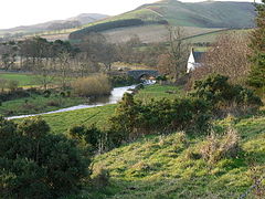 Primsidehill | |
|---|---|
| Tu ne cede malis sed contra audenitor ito (Yield not to misfortunes but advance boldly against them) | |
| |
| [Interactive map] | |
| Area: | 666 square miles |
| Population: | 50,800 |
| County town: | Jedburgh |
| County flower: | Maiden pink [1] |
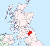
The County of Roxburgh is an inland shire; the middlemost of the Middle Shires it looks both west and east. Historically it was a lawless place between north and south, the victim of the mediæval border wars and the dark heart of reiver country. Today it is somewhat quieter and enjoyed for the scenery of its hills and dales.
To the west of Roxburghshire is Dumfriesshire and to the south-west Cumberland. To the north-east are Berwickshire and Selkirkshire and to the south and south-east is Northumberland. The shire was named after the Royal Burgh of Roxburgh on the Tweed, but the old town was destroyed repeatedly in the border wars of the Middle Ages and after the final fall of Berwick in 1460 it was abandoned.
The lie of the land
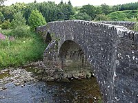
Roxburghshire is a mountainous county: the only low-lying ground in the shire is found in the north and in the valleys of the larger rivers, of which the Tweed is the greatest. The towns of the county are found in the valleys: Hawick in Teviotdale and Jedburgh above it in Jedvale, Newtown St Boswells and Kelso on the Tweed.
One of the main routes from Newcastle upon Tyne to Edinburgh runs across these fells, crossing from Northumberland to Roxburghshire at Carter Bar.
There are pastoral and arable farms in the county; the growing crops are largely in the dales and the hillsides are green and grazed eagerly by abundant flocks and herds.
The dales of the Tweed and Teviot are marked in places by beautiful woodland.
Hills
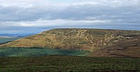
The Cheviots stretch through Roxburghshire and Northumberland and their highest ridges mark much of the border between the two counties, Roxburghshire's own county top being Auchope Cairn, a subsidiary summit of Cairn Hill, on the Northumberland border and on the flank of The Cheviot itself.
The Cheviot hills of Roxburghshire include:
- Catcleuch Shin (1,742 feet)
- Peel Fell (1,964 feet)
The hills form the watershed between the east coast and the west coast, Teviotdale running east and Liddesdale running west, including:
- Cauldcleuch Head (1,996 feet)
- Greatmoor (1,964 feet)
- Pennygant (1,805 feet)
- Din Fell (1,735 feet)
- Wyndburgh Hill (1,622 feet)
- Arnton Fell (1,464 feet).
Rivers and lakes
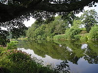
The largest river in the county is the Tweed, which enters Roxburghshire in the north, from Selkirkshire, and flows through the north of Roxburghshire for 26 miles; more than a third of the river's whole length, serving as a border river for some twelve miles at either end of this reach.
The Tweed is met by the Bowden and the Teviot, the Allan and the Eden.
The River Teviot carves Teviotdale and is entirely within Roxburghshire. It rises in near Causeway Grain Head on the Dumfriesshire border and runs in a north-easterly direction for 37 miles until it sheds its waters into the growing Tweed at Kelso. To the Teviot flow many lesser rivers and burns, including the Allan Water, the Slitrig, Dean Burn, the Rule, the Jed, the Oxnam and the Kale, and, on the left, Borthwick Water and the Ale.
In the south of Roburghshire is the River Liddel, which forms Liddesdale. The Liddle rises near Peel Fell in the Cheviots and flows south-west to the River Esk for 27 miles. With its tributary, the Kershope, the Liddel forms the border with Cumberland for some miles.
The lakes are few and small, the largest being Yetholm or Primside Loch and Horselaw, both in the parish of Linton among outlying hills of the Cheviots. Teviotdale, Liddesdale, Tweedside and Jedvale are the main valleys.
History
The lands which became Roxburghshire belonged to Northumbria until the tenth or early eleventh century, when the lands north of the Tweed were ceded to the King of Scots. It was made shire ground by King Alexander I during his short reign in the early part of the twelfth century.
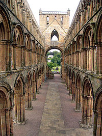
Melrose Abbey had been established in the Anglo-Saxon period and was a noted seat of learning about which Bede wrote. In the twelfth century King David I founded the Abbeys at Jedburgh, Dryburgh and Kelso in his sweep of new monastic foundations, and Jedburgh in particular became a wealthy centre until the Reformation. The shire's main fortification, Roxburgh, was less fortunate; fought over repeatedly during the Middle Ages during which it was mainly held by the English, until the castle and town were finally captured for the Scots and destroyed by King James II.
In later centuries Roxburghshire became Reiver country. The border robbers on each side of the border were cruel and ruthless, none more so than the men of Liddesdale. However, after the accession of King James VI to the English throne, the forces of law could be applied without regard to borders and these lands were brought to peace.
Towns and villages
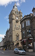
The county has four burghs:
- Jedburgh (royal burgh, county town)
- Hawick
- Kelso
- Melrose
A more recently developed town is:
Parishes
†: Extends into Selkirkshire.
‡: The civil parish of Melrose extends into Berwickshire. The 1,302 acres in question additionally form a detached part of the ancient parish of Lauder.
Additionally parts of the parishes of Selkirk and Galashiels otherwise in Selkirkshire extend into Roxburghshire.
Things to see in Roxburghshire
| Key | |
| Cathedral/Abbey/Priory | |
| Accessible open space | |
| Amusement/Theme Park | |
| Castle | |
| Country Park | |
| Historic Scotland | |
| Forestry Commission | |
| Heritage railway | |
| Historic House | |
| Museum (free/not free) | |
| National Trust for Scotland | |
| Zoo | |
- Cheviot Hills
- Cessford Burn
- Floors Castle
 Harmony Garden
 Hermitage Castle
 Jedburgh Abbey
 Kelso Abbey
 Mellerstain House
 Melrose Abbey
 Monteviot House
 Priorwood Garden
- Scots' Dike
 Smailholm Tower
- Southern Upland Way
- Teviotdale
- Trimontium (Newstead) Roman fort
- Waterloo Monument, Ancrum
Books
- Jeffrey, Alexander: The History and Antiquities of Roxburghshire (Edinburgh, 1857–64)
| Counties of the United Kingdom |
|---|
|
Aberdeen • Anglesey • Angus • Antrim • Argyll • Armagh • Ayr • Banff • Bedford • Berks • Berwick • Brecknock • Buckingham • Bute • Caernarfon • Caithness • Cambridge • Cardigan • Carmarthen • Chester • Clackmannan • Cornwall • Cromarty • Cumberland • Denbigh • Derby • Devon • Dorset • Down • Dumfries • Dunbarton • Durham • East Lothian • Essex • Fermanagh • Fife • Flint • Glamorgan • Gloucester • Hants • Hereford • Hertford • Huntingdon • Inverness • Kent • Kincardine • Kinross • Kirkcudbright • Lanark • Lancaster • Leicester • Lincoln • Londonderry • Merioneth • Middlesex • Midlothian • Monmouth • Montgomery • Moray • Nairn • Norfolk • Northampton • Northumberland • Nottingham • Orkney • Oxford • Peebles • Pembroke • Perth • Radnor • Renfrew • Ross • Roxburgh • Rutland • Selkirk • Shetland • Salop • Somerset • Stafford • Stirling • Suffolk • Surrey • Sussex • Sutherland • Tyrone • Warwick • West Lothian • Westmorland • Wigtown • Wilts • Worcester • York |