Cambridgeshire
| Cambridgeshire United Kingdom | |
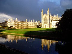
 King's College Chapel and Clare College, Cambridge | |
|---|---|

| |
| Flag | |
| Per undas, per agros (Through waves, through fields) | |

| |
| [Interactive map] | |
| Area: | 858 square miles |
| Population: | 460,448 |
| County town: | Cambridge |
| County flower: | Pasqueflower [1] |
The County of Cambridge is a shire of East Anglia.
The county's dominant natural feature is the fenland, now drained but leaving a flat landscape from Cambridge northward. Cambridgeshire's only hills are the Gog Magog Hills to the south and east of Cambridge and which rise into Suffolk.
Cambridge is the home of the University of Cambridge and is the county's only major town.
Cambridge and its immediate vicinity are a distinctive industrial zone and have been dubbed "Silicon Fen"; an area of high-technology (electronics and computing) companies. Biotechnology has also begun to thrive in Cambridge in recent years, boosted by the excellence in this field of the University of Cambridge.
Most of Cambridgeshire is agricultural, the soil of the former fens yielding rich arable land.
In 2002, the conservation charity Plantlife designated the pasqueflower as Cambridgeshire's county flower.
Geography
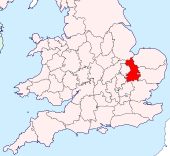
The county is bounded by no fewer than eight other counties: Norfolk to the north-east; Suffolk to the east; Essex to the south-east; Hertfordshire and Bedfordshire to the south-west; Huntingdonshire to the west; Northamptonshire to the north-west; and Lincolnshire to the north.
Large areas of the county are extremely low-lying and many parts of the fenland are below sea level. The highest point is near the village of Castle Camps at the edge of the county, at 413 feet above sea level. The county's only notable heights are Little Trees Hill and Wandlebury Hill in the Gog Magog Hills, Rivey Hill above Linton, Rowley's Hill and the Madingley Hills.
| Extreme points of the county | |
| Highest | Farm at Castle Camps (TL63284188) |
| North | by Tydd St Mary (TF44251852) |
| South | Slip Inn Hill, SW of Odsey (TL290373) |
| West | On Woodbury Low Farm (TL18555414) |
| East | Lane junction W of Dalham (TL718617) |
Once the fens reached into Cambridge itself and northwards to the Wash. The fens have been drained over the past centuries, leaving a distinctive flat landscape. Cutting across the county in two parallel lines from the Great Ouse (at the Huntingdonshire border) to the sea are the Old Bedford River and New Bedford River, two great, tidal drainage channels into which the lesser drains and lodes empty their water.
The one remaining place which gives a sense of the old landscape is Wicken Fen, a nature reserve between Wicken and Upware with 80 acres of reedbed.
History
There is much evidence of the early habitation of Cambridgeshire, back to the Neolithic period. The Icknield Way which marks the county's border with Hertfordshire is believed to be a track dating from the Stone Age. A great quantity of archaeological finds from the Stone Age, the Bronze Age and the Iron Age have been made around Isleham. Several Roman roads are found in Cambridgeshire, and one such road, Worsted Street which crosses the Gog Magog Hills towards Cambridge and now serves as a footpath, is a rare example of a Roman road with Roman paving still in place. Bede wrote of monks rowing to collect stone from an old Roman town near Cambridge which he called "Grantaceaster", thought to be Chesterton, not Grantchester.
In the early Saxon period, Cambridgeshire was on the frontier between the East Angles and the Middle Angles. In this period the two great dykes, the Devil's Dyke and the Fleam Dyke were thrown across the landscape between the hills and the fen, an East Anglian defence line.
Edward the Elder ravaged the land between the Dykes and the Ouse in 905 in liberating the land from the Danes[1] and Cambridgeshire was probably created as a shire at this stage. It appears in the Anglo-Saxon Chronicle as Grantanbrycgscir and variant spellings. During the Middle Ages, the Bishop of Ely was granted the right to govern the northern part of the shire, known as the Isle of Ely. Although the Bishop's effective authority was limited to the City of Ely after the Reformation, the Isle of Ely remained a separate administrative jurisdiction until the middle of the twentieth century.
Due to its flat terrain and proximity to the continent, many RAF and USAAF bases were built for RAF Bomber Command in the Second World War. In recognition of this, the only American burial ground of that war in Britain is located in Madingley; the Cambridge American Cemetery and Memorial.
Original historical documents relating to Cambridgeshire are held by Cambridgeshire Archives and Local Studies.
Settlements

The only major town in Cambridgeshire is the City of Cambridge. The towns of the fenland are Ely, 14 miles north of Cambridge, March and Chatteris to the north-west, and Wisbech, formerly a wealthy port, in the very north of the county.
Cities
Larger villages
- Burwell
- Chatteris
- Littleport
- March
- Sawston
- Soham
- Wisbech (partly in Norfolk)
- Whittlesey
Boundary towns
- Newmarket, Suffolk is surrounded on three sides by Cambridgeshire, being connected at a point to the rest of Suffolk. The county border runs along Newmarket High Street, so while most of the town is in Suffolk, some streets to the south of the High Street fall within Cambridgeshire.
- Royston, Hertfordshire stands on the route of the Icknield Way, which forms the border between Cambridgeshire and Hertfordshire. The town centre is in Hertfordshire, but extensive residential and industrial areas of Royston, as well as the railway station, lie within Cambridgeshire.
Hundreds
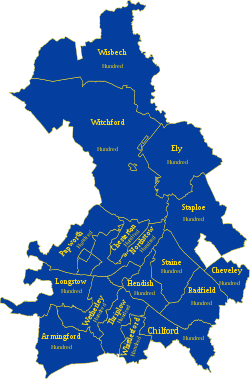
The county is divided into 17 hundreds, or 18 if North and South Witchford are counted separately:
*: These hundreds form the Isle of Ely
Sports
The University of Cambridge cricket team plays as a minor county. Cambridgeshire County Cricket Club, also a minor county, shares its home ground, Fenners.
Cambridge United F.C. are the county's principal football team.
County regiment
The Cambridgeshire Regiment (known as the Fen Tigers) was a regiment of the Territorial Army formed in 1908, when the Cambridgeshire Battalion was separated from the Suffolk Regiment. The Cambridgeshire Battalion had been formed from the county's rifle volunteer units. The Cambridgeshires fought as part of the Suffolk Regiment in South Africa, and as the Cambridgeshire Regiment in the First World War and the Second World War.
In 1947 the Regiment became the 629th Light Anti-Aircraft Regiment, Royal Artillery (The Cambridgeshire Regiment). In 1956 it left the artillery and became the 1st Battalion, The Cambridgeshire Regiment (TA). In 1961 the 1st Cambridgeshires and the 4th Battalion, The Suffolk Regiment amalgamated to form the Suffolk and Cambridgeshire Regiment (TA), then in 1967 its units became part of the Royal Anglian Regiment.
Places of interest
| Key | |
| Cathedral/Abbey/Priory | |
| Accessible open space | |
| Amusement/Theme Park | |
| Castle | |
| Country Park | |
| English Heritage | |
| Forestry Commission | |
| Heritage railway | |
| Historic House | |
| Museum (free/not free) | |
| National Trust | |
| Zoo | |
|
|
References
- ↑ Þa for Eadweard cyning æfter, swa he raðost mihte his fyrd gegaderian, 7 oferhergode eall hyra land betweoh dicum 7 Wusan eall oð fennas norð Anglo-Saxon Chronicle, 905
Outside links
- Cambridgeshire.net community directory
- The Fens of North Cambridgeshire
- Cambridge Market Place Webcam
- Cambridgeshire Family History Society
- The Cambridge Time Traveller Group - History
- Cambridgeshire Community Archive Network.
- Cambridgeshire Churches
| Counties of the United Kingdom |
|---|
|
Aberdeen • Anglesey • Angus • Antrim • Argyll • Armagh • Ayr • Banff • Bedford • Berks • Berwick • Brecknock • Buckingham • Bute • Caernarfon • Caithness • Cambridge • Cardigan • Carmarthen • Chester • Clackmannan • Cornwall • Cromarty • Cumberland • Denbigh • Derby • Devon • Dorset • Down • Dumfries • Dunbarton • Durham • East Lothian • Essex • Fermanagh • Fife • Flint • Glamorgan • Gloucester • Hants • Hereford • Hertford • Huntingdon • Inverness • Kent • Kincardine • Kinross • Kirkcudbright • Lanark • Lancaster • Leicester • Lincoln • Londonderry • Merioneth • Middlesex • Midlothian • Monmouth • Montgomery • Moray • Nairn • Norfolk • Northampton • Northumberland • Nottingham • Orkney • Oxford • Peebles • Pembroke • Perth • Radnor • Renfrew • Ross • Roxburgh • Rutland • Selkirk • Shetland • Salop • Somerset • Stafford • Stirling • Suffolk • Surrey • Sussex • Sutherland • Tyrone • Warwick • West Lothian • Westmorland • Wigtown • Wilts • Worcester • York |