Cromartyshire: Difference between revisions
No edit summary |
mNo edit summary |
||
| Line 13: | Line 13: | ||
The county's [[county top|highest point]] is [[Sgùrr Mòr]] in the [[Fannichs]], standing at 3,642 feet. | The county's [[county top|highest point]] is [[Sgùrr Mòr]] in the [[Fannichs]], standing at 3,642 feet. | ||
The greatest freshwater lochs of Cromartyshire are in its mountainous regions. The largest is [[Loch Fannich]], under the shadow of the mountains of the same name, but which is shared with Ross-shire. In the [Coigach]] area, in the far north-west, 243 feet above the sea, lies [[Loch Sionascaig]], wholly in Cromartyshire and a loch of such irregularity of outline that it has a shore-line of 17 miles. It contains several wooded islands, and drains into Enard Bay by the River Polly. | The greatest freshwater lochs of Cromartyshire are in its mountainous regions. The largest is [[Loch Fannich]], under the shadow of the mountains of the same name, but which is shared with Ross-shire. In the [[Coigach]] area, in the far north-west, 243 feet above the sea, lies [[Loch Sionascaig]], wholly in Cromartyshire and a loch of such irregularity of outline that it has a shore-line of 17 miles. It contains several wooded islands, and drains into Enard Bay by the River Polly. | ||
The arrangement of scattered parcels as one shire arises from the seventeenth century and the influence of George Mackenzie when the sheriff of Cromarty in 1685 and 1698. An influential man in the court in the days of King Charles II, James VII and William and Mary, he owned several estates in Cromartyshire as it was and in Ross and he sought to bring them together into one county, which was duly enacted. Mackenzie was later ennobled as Earl of Cromartie. | The arrangement of scattered parcels as one shire arises from the seventeenth century and the influence of George Mackenzie when the sheriff of Cromarty in 1685 and 1698. An influential man in the court in the days of King Charles II, James VII and William and Mary, he owned several estates in Cromartyshire as it was and in Ross and he sought to bring them together into one county, which was duly enacted. Mackenzie was later ennobled as Earl of Cromartie. | ||
Revision as of 20:35, 17 June 2015
| Cromartyshire United Kingdom | |
 Summer Isles and Coigach behind | |
|---|---|

| |
| [Interactive map] | |
| Area: | 370 square miles |
| Population: | 7,074 |
| County town: | Cromarty |
| Biggest town: | Ullapool |
| County flower: | Spring cinquefoil [1] |
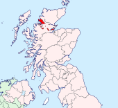
The County of Cromarty is a shire of the Highlands of Scotland, and certainly the most unusual in form. Cromartyshire consists of a number of physically-separated areas scattered across Ross from the east to the west coast. As Cromartyshire and Ross-shire are thoroughly interlaced, it is common to consider the geography of Cromartyshire and of Ross-shire together, the two being in practical terms inseparable.
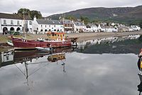
Cromarty is the county town. It stands on the Black Isle on the North Sea coast, while the county's largest town, the fishing village of Ullapool, stands on the Atlantic coast. With just under seven thousand residents, Cromartyshire is the least-populous county in the United Kingdom.
The county's highest point is Sgùrr Mòr in the Fannichs, standing at 3,642 feet.
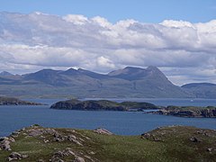
The greatest freshwater lochs of Cromartyshire are in its mountainous regions. The largest is Loch Fannich, under the shadow of the mountains of the same name, but which is shared with Ross-shire. In the Coigach area, in the far north-west, 243 feet above the sea, lies Loch Sionascaig, wholly in Cromartyshire and a loch of such irregularity of outline that it has a shore-line of 17 miles. It contains several wooded islands, and drains into Enard Bay by the River Polly.
The arrangement of scattered parcels as one shire arises from the seventeenth century and the influence of George Mackenzie when the sheriff of Cromarty in 1685 and 1698. An influential man in the court in the days of King Charles II, James VII and William and Mary, he owned several estates in Cromartyshire as it was and in Ross and he sought to bring them together into one county, which was duly enacted. Mackenzie was later ennobled as Earl of Cromartie.
The portions of Cromartyshire
Cromartyshire consists of twenty-three separated portions. Other counties with some detached parts have a main body of the county and detached parts nearby and in following that practice it is usual to consider the principal portion to be that containing the county town, Cromarty, but this is not the largest portion of the county but the second-largest, and is just one-sixth the size of the largest portion, the district of Coigach in the northwest.
The parts of Cromartyshire (with Ordnance Survey numbering and a grid reference for an approximate middle of each) are:
|
Main body: Cromarty, Resolis (NH697634) Det 1. Plaids (NH789825) Det 2. Cnocan Mealbhain, Balcherry (NH818831) Det 3. Knockbreck, Hilton (NH788806) Det 4. Inver, Summerton, Lochslin (NH845814) Det 5. Tarbat: Tarbat Ness to Portmahomack (NH935862) Det 6. Tarrel (NH900809) Det 7. Cadboll (NH881783) Det 8. Delny and Tullich Muir (NH736735) Det 9. Milton, Kilmuir, Kildary (NH773744) Det 10. Coigach and the Summer Isles (includes Ullapool) (NC163053) – largest part of the shire Det 11. Amat (Strathcarron) (NH491904) |
Det 12. Dounie (Strathcarron) (NH548887) Det 13. South of Gruinard Island (NG944931) Det 14. Gruinard House, north bank of the Gruinard River (NG975912) Det 14a. Scoraig (north shore of Little Loch Broom) (NH026954) Det 15. Dundonnell, upper reach of Little Loch Broome (NH090880) Det 16. Carn Goraig and Loch Mòr Bad an Ducharaich (NH000860) Det 17. Airigh Ghoirid (NH127836) Det 18. Inverbroom, Fain (NH138787) Det 19. Tollomuick Forest (NH340800) Det 20. Fannich Forest (north of Loch Fannich & includes Sgùrr Mòr, the county top) (NH200694) Det 21. Fodderty (Strathpeffer, Glensgaith) (NH464616) |


These estates which together are Cromartyshire are spread from the east coast to the west and deep inland, with a fine variety among them. The "old shire" around Cromarty is the northern part of the Black Isle, the low-lying, broad peninsula of the gentle east coast, and like it are the lands of on the Nigg peninsula to the north; Tarbat, Tarrel and Cadboll along the North Sea coast and the pockets east of Tain around Plaids and Cnocan Mealbhain on the beautiful Dornoch Firth and Knockbreck and Inver inland but barely raised from the sea; this is a land of small farmsteads.
In contrast is Coigach, a high, mountainous district on the wild western coast. The west coast is cut with deep sea-lochs, and Cromartyshire's parts lie along the loch shores and along the Gruinard River as it makes its way from the lochs in the mountains down to Gruinard House on the shore.
Two further parcels lie in Strathcarron, inland and upstream on the south bank of the River Carron and reaching up into the hills. (Gruinards Lodge and Wester Gruinards bear witness to the common ownership of these estates with that of the western coast.)
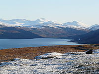
Other parts are lands more of the mountains: Fodderty itself is relatively low-lying, close to Ross-shire's county town, Dingwall, but its parish reaches high into forested hills, while the Fannichs and Loch Fannich itself, are bleak, mountain fastness and of that sublime beauty for which the Highlands are known. The Fannichs lie on the watershed between east and west, while to the northwest the estate attached to Inverbroom provides some more of such dramatic Highland scenery.
Thus Cromartyshire, though a mixed up, bizarre county as mapped, samples some of the best of all of the landscapes of ancient Ross.
History
The name of Cromartyshire comes from its county town, Cromarty on the tip of the Black Isle, whose name is from the Gaelic language but of uncertain origin, probably with the element crum meaning "crooked" and interpreted variously as "crooked bay" or the "bend between the heights".
Cromartyshire itself is an ancient shire, which was a hereditary sheriffdom in the family of Urquhart of Cromarty. In the latter part of the 17th century the sheriffdom was obtained by Viscount Tarbat, afterwards Earl of Cromartie, who was a most influential man at court and in Parliament in the reign of William and Mary. In 1690 at his instance several detached districts were annexed to the shire by authority of Parliament; consisting of all the lands in Ross-shire which were then owned by him, his mother or his mother-in-law.[1] Thus an incomprehensible county was created, which if nothing else is a lesson in not letting politicians get their hands on geography.
The ancient sheriffdom, or old shire, comprises Cromarty parish, the greater part of Resolis parish, and a portion of the parish of Millbuie.[2]
The shire has developed on both coasts. On the North Sea coast, on the Cromarty Firth is Cromarty whose port was formerly used by ferries, to export locally-grown hemp fibre, and by trawlers trawling for herrings. The port was a base for the Royal Navy during the First World War.
On the Atlantic coast, Ullapool on Loch Broom was founded as a herring-fishing port in 1788 by the British Fisheries Society. The town was designed by Thomas Telford.
Towns and villages

Major towns
Smaller towns and villages
|
Parishes
*: Shared with Ross-shire
References
- ↑ Records of the Parliament of Scotland convened at Edinburgh, 19 July 1690:
Act in favours of the viscount of Tarbat: Our soveraigne lord and lady the king and queen's majesties, considering that by act of parliament in anno jM vjC and eighty five the barony of Tarbat and severall other lands in Rosshire were dissolved from it and annexed to the shire of Cromartie, but in the yeare 1686 the said act of annexatione was rescinded on pretence that it included lands not belonging to the viscount of Tarbat, in whose favours the annexatione to Cromartie was made. And now the said viscount desireing that only the said barony of Tarbat and other lands in Rosshire, which belong to him in property and are presently possest by him or by his mother, or mother in law in liferent and by some wodsetters of his property, should be annexed to the shire of Cromartie, their majesties, in favours of the said viscount and his successors, doe, with consent of the three estates now conveened in parliament, rescind the said act past in anno 1686, and of new annexes the said baronie of Tarbat and all other lands in Rosshire belonging in property to the said viscount and possest as said is, to the shire of Cromartie in all time comeing, and to all effects and as to any other lands contained in that act 1685 not being of the baronie of Tarbat, and not being his other proper lands and possest in manner forsaid, they are to remaine in the shire of Ross as formerly, notwithstanding of this or the other act past in the yeare 1685, but prejudice of the said viscount his other jurisdictions in these lands as accords. - ↑ Groome, F H: Ordnance Gazetteer of Scotland (1882-4)
| Counties of the United Kingdom |
|---|
|
Aberdeen • Anglesey • Angus • Antrim • Argyll • Armagh • Ayr • Banff • Bedford • Berks • Berwick • Brecknock • Buckingham • Bute • Caernarfon • Caithness • Cambridge • Cardigan • Carmarthen • Chester • Clackmannan • Cornwall • Cromarty • Cumberland • Denbigh • Derby • Devon • Dorset • Down • Dumfries • Dunbarton • Durham • East Lothian • Essex • Fermanagh • Fife • Flint • Glamorgan • Gloucester • Hants • Hereford • Hertford • Huntingdon • Inverness • Kent • Kincardine • Kinross • Kirkcudbright • Lanark • Lancaster • Leicester • Lincoln • Londonderry • Merioneth • Middlesex • Midlothian • Monmouth • Montgomery • Moray • Nairn • Norfolk • Northampton • Northumberland • Nottingham • Orkney • Oxford • Peebles • Pembroke • Perth • Radnor • Renfrew • Ross • Roxburgh • Rutland • Selkirk • Shetland • Salop • Somerset • Stafford • Stirling • Suffolk • Surrey • Sussex • Sutherland • Tyrone • Warwick • West Lothian • Westmorland • Wigtown • Wilts • Worcester • York |