Caernarfonshire: Difference between revisions
No edit summary |
|||
| (5 intermediate revisions by 2 users not shown) | |||
| Line 8: | Line 8: | ||
|county town=[[Caernarfon]] | |county town=[[Caernarfon]] | ||
}} | }} | ||
The '''County of Caernarfon''' is a [[Counties of the United Kingdom|shire]] at the very | The '''County of Caernarfon''' is a [[Counties of the United Kingdom|shire]] at the very north-west of [[Wales]]. Its name can also been spelled '''Carnarvonshire''' or in other variants, the spelling "Caernarfonshire" being taken from the Welsh form of the county town's name, which has become the preferred form. | ||
It is a sparsely populated county, its land dominated by the mountain fastness and towns confined to the coastal lands. A large proportion of the population is Welsh-speaking. | It is a sparsely populated county, its land dominated by the mountain fastness and towns confined to the coastal lands. A large proportion of the population is Welsh-speaking. | ||
| Line 17: | Line 17: | ||
The county is bounded to the north by the [[Irish Sea]], to the east by [[Denbighshire]], to the south by [[Cardigan Bay]] and [[Merionethshire]], and to the west by Caernarfon Bay and the [[Menai Strait]], across which lies [[Anglesey]]. | The county is bounded to the north by the [[Irish Sea]], to the east by [[Denbighshire]], to the south by [[Cardigan Bay]] and [[Merionethshire]], and to the west by Caernarfon Bay and the [[Menai Strait]], across which lies [[Anglesey]]. | ||
The county has a largely mountainous surface. A large part of Snowdonia lies in the centre and south of the county, including [[Snowdon]] itself, the highest mountain in [[Wales]] at 3,560 feet. The north-west of the county is formed by the [[Llŷn]] peninsula, with [[Bardsey Island]] lying off its westernmost tip. The north of the county, between the mountains and Menai Strait, is a nearly level plain. The east of the county is part of Vale of Conwy, with the [[River Conwy]] forming much of the eastern boundary. [[Llandudno]] and [[Creuddyn]] forms a small peninsula to the north-east across the Conwy estuary.<ref name=lewis>{{cite web |url=http://www.british-history.ac.uk/report.aspx?compid=47810#s2 |title=Carnarvonshire |accessdate=2008-07-27 |author=Samuel Lewis (editor) |year=1849 |work=A Topographical Dictionary of Wales |publisher=British History Online}}</ref> | The county has a largely mountainous surface. A large part of Snowdonia lies in the centre and south of the county, including [[Snowdon]] itself, the highest mountain in [[Wales]] at 3,560 feet. The north-west of the county is formed by the [[Llŷn]] peninsula, with [[Bardsey Island]] lying off its westernmost tip. The north of the county, between the mountains and Menai Strait, is a nearly level plain. The east of the county is part of Vale of Conwy, with the [[River Conwy]] forming much of the eastern boundary. [[Llandudno]] and [[Creuddyn]] forms a small peninsula to the north-east across the Conwy estuary.<ref name=lewis>{{cite web |url=http://www.british-history.ac.uk/report.aspx?compid=47810#s2 |title=Carnarvonshire |accessdate=2008-07-27 |author=Samuel Lewis (editor) |year=1849 |work=A Topographical Dictionary of Wales |publisher=British History Online}}</ref> The county has a detached part east of here, centred on [[Llysfaen]], that also forms part of the [[Creuddyn Hundred|hundred of Creuddyn]]. | ||
The principal towns of the county are [[Bangor, Caernarfonshire|Bangor]], [[Betws-y-Coed]], [[Caernarfon]], [[Conwy]], Llandudno, [[Porthmadog]] and [[Pwllheli]]. Bangor is a university and cathedral city, seat of Bangor University and [[Bangor Cathedral]]. | The principal towns of the county are [[Bangor, Caernarfonshire|Bangor]], [[Betws-y-Coed]], [[Caernarfon]], [[Conwy]], Llandudno, [[Porthmadog]] and [[Pwllheli]]. Bangor is a university and cathedral city, seat of Bangor University and [[Bangor Cathedral]]. | ||
| Line 39: | Line 39: | ||
==Towns and villages== | ==Towns and villages== | ||
[[File:North Wales Caernarfon Castle.jpg|right|thumb| | [[File:North Wales Caernarfon Castle.jpg|right|thumb|250px|Caernarfon]] | ||
*[[ | ===Cities=== | ||
*[[ | *[[Bangor, Caernarfonshire|Bangor]] | ||
===Towns=== | |||
*[[Caernarfon]] ''([[county town]])'' | |||
*[[Llandudno]] | *[[Llandudno]] | ||
*[[Conwy]] | *[[Conwy]] | ||
| Line 47: | Line 50: | ||
*[[Porthmadog]] | *[[Porthmadog]] | ||
== | ===Civil communities=== | ||
{{parishliststart}} | {{parishliststart}} | ||
*[[Aber]] | *[[Aber]] | ||
| Line 53: | Line 56: | ||
*[[Bangor, Caernarfonshire|Bangor]] | *[[Bangor, Caernarfonshire|Bangor]] | ||
*[[Beddgelert]] | *[[Beddgelert]] | ||
*[[Bethesda]] | *[[Bethesda, Caernarfonshire|Bethesda]] | ||
*[[Betws Garmon]] | *[[Betws Garmon]] | ||
*[[Betws-y-Coed]] | *[[Betws-y-Coed]] | ||
*[[Bontnewydd]] | *[[Bontnewydd, Caernarfonshire|Bontnewydd]] | ||
*[[Botwnnog]] | *[[Botwnnog]] | ||
*[[Bro Machno]] | *[[Bro Machno]] | ||
| Line 84: | Line 87: | ||
*[[Llannor]] | *[[Llannor]] | ||
*[[Llanrug]] | *[[Llanrug]] | ||
*[[Llanwnda]] | *[[Llanwnda, Caernarfonshire|Llanwnda]] | ||
*[[Llanystumdwy]] | *[[Llanystumdwy]] | ||
*[[Nefyn]] | *[[Nefyn]] | ||
| Line 100: | Line 103: | ||
==History== | ==History== | ||
[[File:Gwynedd fields.jpg|thumb| | [[File:Gwynedd fields.jpg|thumb|250px|Tremadog Bay]] | ||
From the end of the Roman period until the 13th Century, the land which became Caernarfonshire was at the heart of the Kingdom of Gwynedd, whose Kings claimed the title "King of Britain" until calamitous attempt to turn the title into reality in the late seventh century. | From the end of the Roman period until the 13th Century, the land which became Caernarfonshire was at the heart of the Kingdom of [[Gwynedd]], whose Kings claimed the title "King of Britain" until calamitous attempt to turn the title into reality in the late seventh century. | ||
Gwynedd was finally put down by King Edward I but in the final rebellion Llywelyn ap Gruffydd retreated into Snowdonia, an impenetrable fastness. In response, King Edward built his "iron ring" of castles around Snowdonia, the most famous of which was Caernarfon Castle. | Gwynedd was finally put down by King Edward I but in the final rebellion Llywelyn ap Gruffydd retreated into Snowdonia, an impenetrable fastness. In response, King Edward built his "iron ring" of castles around Snowdonia, the most famous of which was Caernarfon Castle. | ||
| Line 110: | Line 113: | ||
The county was originally created under the terms of the Statute of Rhuddlan in 1284 after Edward I had removed the last Welsh prince. It brought together the ''cantrefi'' of Llŷn, Arfon and Arllechwedd and the ''commote'' of Eifionydd (the northern portion of the cantref of Dunoding).<ref>Waters, W. H., The Making of Caernarvonshire, ''Caernarvonshire Historical Society Transactions'', 1942-43</ref> | The county was originally created under the terms of the Statute of Rhuddlan in 1284 after Edward I had removed the last Welsh prince. It brought together the ''cantrefi'' of Llŷn, Arfon and Arllechwedd and the ''commote'' of Eifionydd (the northern portion of the cantref of Dunoding).<ref>Waters, W. H., The Making of Caernarvonshire, ''Caernarvonshire Historical Society Transactions'', 1942-43</ref> | ||
The county was divided into ten hundreds based on the existing | The county was divided into ten hundreds based on the existing commotes: Cymydmaen (anglicised as [[Commitmaen]]), [[Creuddyn Hundred|Creuddyn]], [[Dinllaen]], [[Eifionydd]] (Evionydd), [[Gafflogion]] (Gaflogion), [[Isaf|Arllechwedd Isaf]], [[Uchaf|Arllechwedd Uchaf]], [[Nant Conwy]] (Nant-Conway), [[Is Gwyrfai]] (Isgorvai) and [[Uwch Gwyrfai]] (Uchgorvai).<ref name=lewis/><ref>{{cite web |url=http://www.visionofbritain.org.uk/gaztext_page.jsp?u_id=10134651&c_id=10001043 |title=Carnarvonshire |accessdate=2008-07-27 |author=John Bartholomew |year=1887 |work=Gazeteer of the British Isles |publisher=Vision of Britain}}</ref> | ||
===Nineteenth and twentieth centuries=== | ===Nineteenth and twentieth centuries=== | ||
Latest revision as of 20:24, 17 February 2023
| Caernarfonshire Welsh: Sir Gaernarfon United Kingdom | |
 Snowdon from Llyn Llydaw | |
|---|---|

| |
| Flag | |
| Cadernid Gwynedd (The strength of Gwynedd) | |

| |
| [Interactive map] | |
| Area: | 563 square miles |
| Population: | 139,065 |
| County town: | Caernarfon |
| County flower: | Snowdon lily [1] |
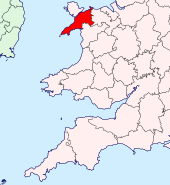
The County of Caernarfon is a shire at the very north-west of Wales. Its name can also been spelled Carnarvonshire or in other variants, the spelling "Caernarfonshire" being taken from the Welsh form of the county town's name, which has become the preferred form.
It is a sparsely populated county, its land dominated by the mountain fastness and towns confined to the coastal lands. A large proportion of the population is Welsh-speaking.
Caernarfonshire may be reckoned to have three distinctive areas: the coastal lands (Arfon and the coast to the River Conwy), Snowdonia and the Llŷn Peninsula.
Geography
The county is bounded to the north by the Irish Sea, to the east by Denbighshire, to the south by Cardigan Bay and Merionethshire, and to the west by Caernarfon Bay and the Menai Strait, across which lies Anglesey.
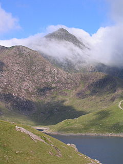
The county has a largely mountainous surface. A large part of Snowdonia lies in the centre and south of the county, including Snowdon itself, the highest mountain in Wales at 3,560 feet. The north-west of the county is formed by the Llŷn peninsula, with Bardsey Island lying off its westernmost tip. The north of the county, between the mountains and Menai Strait, is a nearly level plain. The east of the county is part of Vale of Conwy, with the River Conwy forming much of the eastern boundary. Llandudno and Creuddyn forms a small peninsula to the north-east across the Conwy estuary.[1] The county has a detached part east of here, centred on Llysfaen, that also forms part of the hundred of Creuddyn.
The principal towns of the county are Bangor, Betws-y-Coed, Caernarfon, Conwy, Llandudno, Porthmadog and Pwllheli. Bangor is a university and cathedral city, seat of Bangor University and Bangor Cathedral.
Arfon
The name of Arfon comes from its position opposite the Isle of Anglesey (Môn). Here the land is a flat, coastal plain but here stands also the county town, Caernarfon, whose name means "Arfon-fort.
Snowdonia
- Main article: Snowdonia
Snowdonia (Welsh: Eryri) is the name given to the massif spread across the heart of Caernarfonshire and centred on Snowdon itself, the highest mountain south of the Forth. Snowdonia was formerly known as the Forest of Snowdon (at the end of the sixteenth century, William Camden noted Snowdonia as a name used by Latin scholars). The unrelated Welsh name is ancient.
Camden was greatly impressed by the Forest of Snowdon:
| “ | A man may truely, if hee please, terme these mountaines the British Alpes: for, besides that they are the greatest of the whole Island, they are no lesse steepe also with cragged and rent rockes on every side than the Alpes of Italie, yea and all of them compasse one mountaine round about, which over-topping the rest so towreth up with his head aloft in the aire as hee may seeme not to threaten the skie, but to thrust his head up into heaven.[2] | ” |
The Snowdonia National Park was created in 1951 to cover Snowdonia and a much wider mountain area of Caernarfonshire and Merionethshire.
The Llŷn Peninsula
- Main article: Llŷn
Llŷn or Lleyn is the peninsula stretching out into the Irish Sea, shaped like an arm projecting from North Wales. Llŷn is a rural land of farms and villages, and largely Welsh-speaking. At its end is Aberdaron, the parish where R S Thomas served as vicar, and beyond the island of Bardsey.
Towns and villages

Cities
Towns
Civil communities
- Aber
- Aberdaron
- Bangor
- Beddgelert
- Bethesda
- Betws Garmon
- Betws-y-Coed
- Bontnewydd
- Botwnnog
- Bro Machno
- Buan
- Caerhun
- Caernarfon
- Capel Curig
- Clynnog
- Conwy
- Criccieth
- Dolbenmaen
- Dolgarrog
- Dolwyddelan
- Henryd
- Llanaelhaearn
- Llanbedrog
- Llanberis
- Llanddeiniolen
- Llanddoged and Maenan
- Llandudno
- Llandwrog
- Llandygai
- Llanengan
- Llanfairfechan
- Llanllechid
- Llanllyfni
- Llannor
- Llanrug
- Llanwnda
- Llanystumdwy
- Nefyn
- Penmaenmawr
- Pentir
- Pistyll
- Porthmadog
- Pwllheli
- Trefriw
- Tudweiliog
- Waunfawr
- Y Felinheli
- Ysbyty Ifan
History

From the end of the Roman period until the 13th Century, the land which became Caernarfonshire was at the heart of the Kingdom of Gwynedd, whose Kings claimed the title "King of Britain" until calamitous attempt to turn the title into reality in the late seventh century.
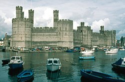
Gwynedd was finally put down by King Edward I but in the final rebellion Llywelyn ap Gruffydd retreated into Snowdonia, an impenetrable fastness. In response, King Edward built his "iron ring" of castles around Snowdonia, the most famous of which was Caernarfon Castle.
Caernarfon became the seat of the Principality of Wales throughout the Middles Ages, and in the Principality shires were formed, amongst them Carnarvonshire.
Middle Ages
The county was originally created under the terms of the Statute of Rhuddlan in 1284 after Edward I had removed the last Welsh prince. It brought together the cantrefi of Llŷn, Arfon and Arllechwedd and the commote of Eifionydd (the northern portion of the cantref of Dunoding).[3]
The county was divided into ten hundreds based on the existing commotes: Cymydmaen (anglicised as Commitmaen), Creuddyn, Dinllaen, Eifionydd (Evionydd), Gafflogion (Gaflogion), Arllechwedd Isaf, Arllechwedd Uchaf, Nant Conwy (Nant-Conway), Is Gwyrfai (Isgorvai) and Uwch Gwyrfai (Uchgorvai).[1][4]
Nineteenth and twentieth centuries
During the 19th century Caernarfonshire's population increased steadily, from 46,000 in the 1801 census to 137,000 in the 1901 census.
In the early nineteenth century consideration was given to a new port to provide swift passage between Great Britain and Dublin, not least for Irish members of Parliament. One early proposal was to develop the fishing village of Porthdinllaen. Ultimately though the prize went to Holyhead on Holy Island, Anglesey, and in due course the first of the great bridges across the Menai Strait was built from Anglesey to Caernarfonshire, and Telford's road. This was followed by the railway and a new bridge over the Strait, all of which changed the nature of Arfon forever, as towns grew on the new transport routes.
In 1951 the Snowdonia National park was created, covering much of Caernarvonshire and Merionethshire.
Places of interest

| Key | |
| Cathedral/Abbey/Priory | |
| Accessible open space | |
| Amusement/Theme Park | |
| Castle | |
| Country Park | |
| Cadw | |
| Forestry Commission | |
| Heritage railway | |
| Historic House | |
| Museum (free/not free) | |
| National Trust | |
| Zoo | |
- Bardsey Island SH1221
 Caernarfon Castle SH4762
 Conwy Castle SH7877
 Criccieth Castle SH4937
- Great Orme Tramway, Llandudno SH7883
 Gwydir Castle, near Llanrwst SH7961
 Penrhyn Castle SH6071
- Swallow Falls, Betws-y-Coed SH7657
- Snowdon
- Snowdon Mountain Railway, Llanberis SH5859
 Tŷ Mawr Wybrnant SH7752
See also
Outside links
References
- ↑ 1.0 1.1 Samuel Lewis (editor) (1849). "Carnarvonshire". A Topographical Dictionary of Wales. British History Online. http://www.british-history.ac.uk/report.aspx?compid=47810#s2. Retrieved 2008-07-27.
- ↑ William Camden - Britannia
- ↑ Waters, W. H., The Making of Caernarvonshire, Caernarvonshire Historical Society Transactions, 1942-43
- ↑ John Bartholomew (1887). "Carnarvonshire". Gazeteer of the British Isles. Vision of Britain. http://www.visionofbritain.org.uk/gaztext_page.jsp?u_id=10134651&c_id=10001043. Retrieved 2008-07-27.
Books
- A.H. Dodd, The History of Caernarvonshire (Caernarfonshire Historical Society, 1968).
- John Jones, Enwau Lleoedd Sir Gaernarfon (Caernarfon, 1913). Origin and meanings of place names in the county.
| Counties of the United Kingdom |
|---|
|
Aberdeen • Anglesey • Angus • Antrim • Argyll • Armagh • Ayr • Banff • Bedford • Berks • Berwick • Brecknock • Buckingham • Bute • Caernarfon • Caithness • Cambridge • Cardigan • Carmarthen • Chester • Clackmannan • Cornwall • Cromarty • Cumberland • Denbigh • Derby • Devon • Dorset • Down • Dumfries • Dunbarton • Durham • East Lothian • Essex • Fermanagh • Fife • Flint • Glamorgan • Gloucester • Hants • Hereford • Hertford • Huntingdon • Inverness • Kent • Kincardine • Kinross • Kirkcudbright • Lanark • Lancaster • Leicester • Lincoln • Londonderry • Merioneth • Middlesex • Midlothian • Monmouth • Montgomery • Moray • Nairn • Norfolk • Northampton • Northumberland • Nottingham • Orkney • Oxford • Peebles • Pembroke • Perth • Radnor • Renfrew • Ross • Roxburgh • Rutland • Selkirk • Shetland • Salop • Somerset • Stafford • Stirling • Suffolk • Surrey • Sussex • Sutherland • Tyrone • Warwick • West Lothian • Westmorland • Wigtown • Wilts • Worcester • York |