Dumfriesshire: Difference between revisions
| (7 intermediate revisions by 3 users not shown) | |||
| Line 8: | Line 8: | ||
The '''County of Dumfries''' is a [[Counties of the United Kingdom|shire]] on the north shore of the [[Solway Firth]]. Its [[county town]] is [[Dumfries]]. | The '''County of Dumfries''' is a [[Counties of the United Kingdom|shire]] on the north shore of the [[Solway Firth]]. Its [[county town]] is [[Dumfries]]. | ||
Dumfriesshire borders [[Kirkcudbrightshire]] to the west | Dumfriesshire borders [[Kirkcudbrightshire]] to the west; [[Cumberland]] to the south; [[Ayrshire]] to the north-west; [[Lanarkshire]], [[Peeblesshire]] and [[Selkirkshire]] to the north; and [[Roxburghshire]] to the east. The coast of the [[Solway Firth]] forms its southern edge. | ||
The county | The county has three divisions based on its physical geography; [[Annandale]], [[Eskdale, Dumfriesshire|Eskdale]] and [[Nithsdale]], the latter of which also forms the border with [[Kirkcudbrightshire]]. | ||
===Geography=== | ===Geography=== | ||
| Line 51: | Line 51: | ||
Other rivers of Dumfriesshire include the [[Lochar Water]], the [[Kirtle Water|Kirtle]] and the [[River Sark|Sark]], all flowing into the Solway. For the last 7 miles of its course the Sark forms the boundary between Dumfriesshire and Cumberland. | Other rivers of Dumfriesshire include the [[Lochar Water]], the [[Kirtle Water|Kirtle]] and the [[River Sark|Sark]], all flowing into the Solway. For the last 7 miles of its course the Sark forms the boundary between Dumfriesshire and Cumberland. | ||
The plain between the Esk and the Sark was once hotly disputed ground, disputed between Scotland and England and controlled by neither but by the Armstrongs and such reiver families. The matter was not settled until the | The plain between the Esk and the Sark was once hotly disputed ground, disputed between Scotland and England and controlled by neither but by the Armstrongs and such reiver families. The matter was not settled until the Debatable Lands were divided between the two in 1552; 51 years before King James VI and I made the border irrelevant. | ||
[[Loch Skeen]] in the north (found 1,750 feet above sea level) and the group of lochs around [[Lochmaben]], are the principal lakes. Out of Loch Skene flows the [[Tail Burn]], which soon afterwards leaps from a height of 200 feet in a fine waterfall, known as the Grey Mare's Tail. A much smaller but picturesque fall of the same name, also known as [[Crichope Linn]], is seen on the Crichope near [[Thornhill, Dumfriesshire|Thornhill]]. | [[Loch Skeen]] in the north (found 1,750 feet above sea level) and the group of lochs around [[Lochmaben]], are the principal lakes. Out of Loch Skene flows the [[Tail Burn]], which soon afterwards leaps from a height of 200 feet in a fine waterfall, known as the Grey Mare's Tail. A much smaller but picturesque fall of the same name, also known as [[Crichope Linn]], is seen on the Crichope near [[Thornhill, Dumfriesshire|Thornhill]]. | ||
| Line 58: | Line 58: | ||
The Glasgow and South Western Railway from [[Glasgow]] to [[Carlisle]] was built through Nithsdale to Dumfries, along the River Nith, then on to [[Annan]] and lower Annandale to [[Gretna]]. A branch was built from [[Dumfries]] to [[Moniaive]] closed in 1949. The Caledonian Railway was built from [[Carlisle]] to [[Glasgow]] through Annandale. Former branch lines, to [[Moffat]] and to [[Dumfries]] have now closed, as has a line from [[Kirtlebridge]] across the Solway to [[Bowness-on-Solway]]. | The Glasgow and South Western Railway from [[Glasgow]] to [[Carlisle]] was built through Nithsdale to Dumfries, along the River Nith, then on to [[Annan]] and lower Annandale to [[Gretna]]. A branch was built from [[Dumfries]] to [[Moniaive]] closed in 1949. The Caledonian Railway was built from [[Carlisle]] to [[Glasgow]] through Annandale. Former branch lines, to [[Moffat]] and to [[Dumfries]] have now closed, as has a line from [[Kirtlebridge]] across the Solway to [[Bowness-on-Solway]]. | ||
The Waverley route, to [[Edinburgh]] from [[Carlisle]] was closed in the 1960s and remains so notwithstanding vague plans to reopen it as a continuation of the new rail link | The Waverley route, to [[Edinburgh]] from [[Carlisle]] was closed in the 1960s and remains so notwithstanding vague plans to reopen it as a continuation of the new rail link rebuilt from [[Edinburgh]] to [[Tweedbank]]. | ||
The main road networks follow the Solway coastland and the dales. For many years the motorway network stopped at Carlisle and did not resume until Glasgow, but the two are now linked through Annandale. | The main road networks follow the Solway coastland and the dales. For many years the motorway network stopped at Carlisle and did not resume until Glasgow, but the two are now linked through Annandale. | ||
| Line 87: | Line 87: | ||
*[[Annan]] | *[[Annan]] | ||
*[[Canonbie]] | *[[Canonbie]] | ||
*[[Dumfries]] '' | *[[Dumfries]] ''([[county town]], partly in [[Kirkcudbrightshire]])'' | ||
*[[Eskdalemuir]] | *[[Eskdalemuir]] | ||
*[[Gretna]] | *[[Gretna]] | ||
| Line 99: | Line 99: | ||
{{parishliststart}} | {{parishliststart}} | ||
*[[Annan]] | *[[Annan]] | ||
*[[Applegarth]] | *[[Applegarth, Dumfriesshire|Applegarth]] | ||
*[[Caerlaverock]] | *[[Caerlaverock]] | ||
*[[Canonbie]] | *[[Canonbie]] | ||
| Line 107: | Line 107: | ||
*[[Dornock]] | *[[Dornock]] | ||
*[[Dryfesdale]] | *[[Dryfesdale]] | ||
*[[Dumfries]] | |||
*[[Dunscore]] | *[[Dunscore]] | ||
*[[Durisdeer]] | *[[Durisdeer]] | ||
*[[Eskdalemuir]] | *[[Eskdalemuir]] | ||
*[[Ewes]] | *[[Ewes]] | ||
| Line 116: | Line 116: | ||
*[[Half Morton]] | *[[Half Morton]] | ||
*[[Hoddom]] | *[[Hoddom]] | ||
*[[Holywood]] | *[[Holywood, Dumfriesshire|Holywood]] | ||
*[[Hutton and Corrie]] | *[[Hutton and Corrie]] | ||
*[[Johnstone]] | *[[Johnstone]] | ||
| Line 122: | Line 122: | ||
*[[Kirkconnel]] | *[[Kirkconnel]] | ||
*[[Kirkmahoe]] | *[[Kirkmahoe]] | ||
*[[Kirkmichael, Dumfriesshire]] | *[[Kirkmichael, Dumfriesshire|Kirkmichael]] | ||
*[[Kirkpatrick-Fleming]] | *[[Kirkpatrick-Fleming]] | ||
*[[Kirkpatrick-Juxta]] | *[[Kirkpatrick-Juxta]]<sup>†</sup> | ||
*[[Langholm]] | *[[Langholm]] | ||
*[[Lochmaben]] | *[[Lochmaben]] | ||
*[[Middlebie]] | *[[Middlebie]] | ||
*[[Moffat]] | *[[Moffat]]<sup>†</sup> | ||
*[[Morton]] | *[[Morton]] | ||
*[[Mouswald]] | *[[Mouswald]] | ||
| Line 137: | Line 137: | ||
*[[Tinwald]] | *[[Tinwald]] | ||
*[[Torthorwald]] | *[[Torthorwald]] | ||
*[[Tundergarth]] | |||
*[[Tynron]] | *[[Tynron]] | ||
*[[Wamphray]] | *[[Wamphray]] | ||
*[[Westerkirk]] | *[[Westerkirk]] | ||
{{parishlistend}} | {{parishlistend}} | ||
<sup>†</sup>: Extends into [[Lanarkshire]]. | |||
==Things to see in Dumfriesshire== | ==Things to see in Dumfriesshire== | ||
Latest revision as of 20:16, 24 July 2018
| Dumfriesshire United Kingdom | |
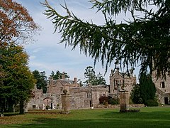 Hoddom Castle, Ecclefechan | |
|---|---|
| |
| [Interactive map] | |
| Area: | 1,063 square miles |
| Population: | 77,160 |
| County town: | Dumfries |
| County flower: | Harebell [1] |
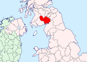
The County of Dumfries is a shire on the north shore of the Solway Firth. Its county town is Dumfries.
Dumfriesshire borders Kirkcudbrightshire to the west; Cumberland to the south; Ayrshire to the north-west; Lanarkshire, Peeblesshire and Selkirkshire to the north; and Roxburghshire to the east. The coast of the Solway Firth forms its southern edge.
The county has three divisions based on its physical geography; Annandale, Eskdale and Nithsdale, the latter of which also forms the border with Kirkcudbrightshire.
Geography
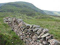
The coastline on the Solway Firth measures 21 miles, deeply indented with estuaries and inlets. The county slopes very gradually from the mountainous districts of the Southern Uplands in the north, down to the sea; lofty hills alternating in parts with stretches of tableland or rich fertile holms. At various points within a few miles of the Firth are tracts of moss land, like Craigs Moss, Lochar Moss and Longbridge Moor in the west, and Nutberry Moss in the east, all once under water, but now largely reclaimed.
In contrast, inland the shire begins to rise into hills and the north is a land of noble fells. The principal mountains are all in the northern confines of the shire, notably:
- White Coomb (2,695 feet: the county top)
- Hart Fell (2,651 feet)
- Saddle Yoke (2,412 feet)
- Swatte Fell (2,389 feet)
- Lowther Hills (2,377 feet)
- Queensberry (2,285 feet)
- Ettrick Pen (2,269 feet)
The high passes of Dalveen, Enterkin and Menock, leading up from Nithsdale to the Lowther Hills, have a wild beauty to them comparable to the glens of the Highlands. For part of the way, the Enterkin Pass runs between mountains rising sheer from the burn to a height of nearly 2,000 feet.
The three longest rivers are the Nith, the Annan and the Esk, the basins of which form the great dales by which the county is cleft from north to south — Nithsdale, Annandale and Eskdale.
Annandale
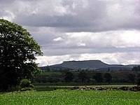
The Annan rises near the Devil's Beef Tub, a remarkable chasm in the far north, and after flowing about 40 miles in a southerly direction to enters the Solway at Barnkirk headland. It receives the waters of the Kinnel (itself fed by the Water of Ae) and the Moffat, the Dryfe and the Water of Milk.
Annandale provides the main route across the Southern Uplands, between Carlisle and Glasgow. It is an ancient route; Roman forts are found here and other earthworks attesting to an ancient route. Along this dale today are pushed the A74(M) (the M6 by another name), the B7016 (once the main A-road) and the main railway line, but these have not obliterated the villages. Ecclefechan remains the wee mistress of its part of the dale and to the north Lockerbie is bustling despite all that has been done to it. The north of the dale is in forest and fell with small villages. At the coast is the town of Annan.
Eskdale
The White Esk (rising near Ettrick Pen) and the Black Esk (rising near Jocks Shoulder) meet to form the River Esk, which flows in a gradually south-easterly direction until it crosses into Cumberland, forming the boundary for a mile, and falls into the Solway.
The White Esk is 12 miles long and the conjoined river flows 30 miles; 20 miles in Dumfriesshire and 10 miles in Cumberland. Its main tributaries are the Wauchope Water the Megget Water, Ewes Water, Tarras Water, Liddel Water and the River Lyne. Of these, the Liddel forms its own dale, Liddesdale, in Roxburghshire and its middle reaches mark the county boundary with Cumberland, while the Lyne is wholly within the latter shire.
The main villages of Eskdale in Dumfriesshire are Langholm and Canonbie in the broader plain to the south. The village of Scotsdike on the west bank of the river runs seamlessly across the border of Cumberland and Dumfriesshire.
Nithsdale
From the point where it enters Dumfriesshire, 16 miles from its source near Enoch Hill in Ayrshire, the course of the Nith is mainly south-easterly until it enters the Solway, a few miles below Dumfries. Its total length is 65 miles, its waters swollen on the way by the Kello, Euchan, Scar, Cluden and Cargen, and — on the left — the Crawick, Carron and Cample.
The Nith forms the boundary with Kirkcudbrightshire to the west. Nithsdale contains villages but its one town is Dumfries itself.
Other rivers and lochs
Other rivers of Dumfriesshire include the Lochar Water, the Kirtle and the Sark, all flowing into the Solway. For the last 7 miles of its course the Sark forms the boundary between Dumfriesshire and Cumberland.
The plain between the Esk and the Sark was once hotly disputed ground, disputed between Scotland and England and controlled by neither but by the Armstrongs and such reiver families. The matter was not settled until the Debatable Lands were divided between the two in 1552; 51 years before King James VI and I made the border irrelevant.
Loch Skeen in the north (found 1,750 feet above sea level) and the group of lochs around Lochmaben, are the principal lakes. Out of Loch Skene flows the Tail Burn, which soon afterwards leaps from a height of 200 feet in a fine waterfall, known as the Grey Mare's Tail. A much smaller but picturesque fall of the same name, also known as Crichope Linn, is seen on the Crichope near Thornhill.
Transport
The Glasgow and South Western Railway from Glasgow to Carlisle was built through Nithsdale to Dumfries, along the River Nith, then on to Annan and lower Annandale to Gretna. A branch was built from Dumfries to Moniaive closed in 1949. The Caledonian Railway was built from Carlisle to Glasgow through Annandale. Former branch lines, to Moffat and to Dumfries have now closed, as has a line from Kirtlebridge across the Solway to Bowness-on-Solway.
The Waverley route, to Edinburgh from Carlisle was closed in the 1960s and remains so notwithstanding vague plans to reopen it as a continuation of the new rail link rebuilt from Edinburgh to Tweedbank.
The main road networks follow the Solway coastland and the dales. For many years the motorway network stopped at Carlisle and did not resume until Glasgow, but the two are now linked through Annandale.
History
Neolithic and Bronze Age remains in Dumfriesshire include stone circles such as those at Dunscore and Eskdalemuir), tumuli and cairn and sculptured stones.
The Romans found here a British tribe named the Selgovae. They have left many signs of their presence, such as hill forts and camps (as at Dryfesdale). The country around Moffat especially is rich in remains. A Roman road ran by Dalveen Pass into Clydesdale and up the Annan to Tweeddale, and at Birrens is one of the best preserved examples of a Roman camp. Roman altars, urns and coins are found in many places.
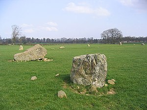
Folk history suggests that at Holywood, near Dumfries, there stand the relic of the grove of sacred oaks from which the place derived its name, and a stone circle known locally as the Twelve Apostles.
After the Romans withdrew to Europe, Dumfriesshire falls into the darkness of unknown history. In time, the local powers coalesced into the English kingdom of the Northumbrians and the Welsh kingdom of Strathclyde, while Irishmen probed the coasts too. Bede's Ecclesiastic History gives some insight into doings of the English church here, and place-names may indicate the influence of peoples with differing languages, but academics argue over these and of when they appeared. In the parish church of Ruthwell (pronounced Rivvel: the rood, or cross, well) is preserved an ancient Anglo-Saxon cross which tells in Runic characters the story of the Crucifixion; a poem known as "the Dream of the Rood".
Dumfriesshire was certainly Scottish by the tenth century. In the later Middle Ages it was a border county and the scene of stirring deeds, especially in the days of Robert Bruce. Edward I besieged Caerlaverock Castle, and the factions of Bruce (who was lord of Annandale), John Comyn and King John I (John Baliol) were at constant feud.
The Border families, as haughty and hot-headed as the Gaelic clans farther north, were always at strife. There is record of a bloody fight in Dryfesdale in 1593, when the Johnstones slew 700 Maxwells, and, overtaking the fugitives at Lockerbie, there massacred most of the remnant. These factions embroiled the dalesmen until the 18th century.
The highlands of the shire afforded retreat to the persecuted Covenanters, who, at Sanquhar, published in 1680 their declaration against the king, anticipating the principles of the Glorious Revolution by several years. The ambitions of Prince Charles Edward, the Young Pretender, left the shire comparatively untouched, for this was a Presbyterian shire with little Jacobite sentiment.
Dumfriesshire is bound in with the fame of Robert Burns, who farmed at Ellisland Farm on the Nith for three years, and spent the last five years of his life at Dumfries.
Thomas Carlyle was born at Ecclefechan, in a house still standing, and was buried beside his parents in the kirkyard of the old Secession church (now the United Free). His farm of Craigenputtock was left to the University of Edinburgh in order to found the John Welsh bursaries in classics and mathematics.
Towns and villages
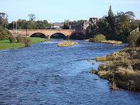
The main towns are:
- Annan
- Canonbie
- Dumfries (county town, partly in Kirkcudbrightshire)
- Eskdalemuir
- Gretna
- Kirkpatrick-Fleming
- Langholm
- Moffat
- Ruthwell
- Sanquhar
Parishes
- Annan
- Applegarth
- Caerlaverock
- Canonbie
- Closeburn
- Cummertrees
- Dalton
- Dornock
- Dryfesdale
- Dumfries
- Dunscore
- Durisdeer
- Eskdalemuir
- Ewes
- Glencairn
- Gretna
- Half Morton
- Hoddom
- Holywood
- Hutton and Corrie
- Johnstone
- Keir
- Kirkconnel
- Kirkmahoe
- Kirkmichael
- Kirkpatrick-Fleming
- Kirkpatrick-Juxta†
- Langholm
- Lochmaben
- Middlebie
- Moffat†
- Morton
- Mouswald
- Penpont
- Ruthwell
- Sanquhar
- St Mungo
- Tinwald
- Torthorwald
- Tundergarth
- Tynron
- Wamphray
- Westerkirk
†: Extends into Lanarkshire.
Things to see in Dumfriesshire
| Key | |
| Cathedral/Abbey/Priory | |
| Accessible open space | |
| Amusement/Theme Park | |
| Castle | |
| Country Park | |
| Historic Scotland | |
| Forestry Commission | |
| Heritage railway | |
| Historic House | |
| Museum (free/not free) | |
| National Trust for Scotland | |
| Zoo | |
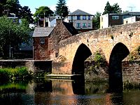
- The Auld Brig, Dumfries
- Caerlaverock Castle
- Gretna Green
- Lochmaben Stone
- Pele towers
- Ruthwell Cross
- The Twelve Apostles stone circle
Outside links
References
Books
- W. M'Dowall, History of the Burgh of Dumfries (Edinburgh, 1887);
- Sir Herbert Maxwell, Dumfries and Galloway (Edinburgh and London, 1897);
- J. Macdonald and J. Barbour, Birrens and its Antiquities (Dumfries, 1897);
- Sir William Fraser, The Book of Carlaverock (Edinburgh, 1873); The Douglas Book (Edinburgh, 1885);
- The Annandale Book (Edinburgh, 1894);
- G. Neilson, Annandale under the Bruces (Annan, 1887);
- C. T. Ramage, Drumlanrig Castle and the Douglases (Dumfries, 1876).
| Counties of the United Kingdom |
|---|
|
Aberdeen • Anglesey • Angus • Antrim • Argyll • Armagh • Ayr • Banff • Bedford • Berks • Berwick • Brecknock • Buckingham • Bute • Caernarfon • Caithness • Cambridge • Cardigan • Carmarthen • Chester • Clackmannan • Cornwall • Cromarty • Cumberland • Denbigh • Derby • Devon • Dorset • Down • Dumfries • Dunbarton • Durham • East Lothian • Essex • Fermanagh • Fife • Flint • Glamorgan • Gloucester • Hants • Hereford • Hertford • Huntingdon • Inverness • Kent • Kincardine • Kinross • Kirkcudbright • Lanark • Lancaster • Leicester • Lincoln • Londonderry • Merioneth • Middlesex • Midlothian • Monmouth • Montgomery • Moray • Nairn • Norfolk • Northampton • Northumberland • Nottingham • Orkney • Oxford • Peebles • Pembroke • Perth • Radnor • Renfrew • Ross • Roxburgh • Rutland • Selkirk • Shetland • Salop • Somerset • Stafford • Stirling • Suffolk • Surrey • Sussex • Sutherland • Tyrone • Warwick • West Lothian • Westmorland • Wigtown • Wilts • Worcester • York |