County Louth
| County Louth Irish: Contae Lú Republic of Ireland | |
 The Cooley Mountains, County Louth | |
|---|---|
.svg)
| |
| [Interactive map] | |
| Province: | Leinster |
| Area: | 317 square miles |
| Population: | 122,897 |
| County seat: | Dundalk |
The County of Louth is a shire in the province of Leinster in the Republic of Ireland. It is named after the town of Louth. The population of the county is 122,897 according to the 2011 census.[1]
Geography
County Louth is colloquially known as 'the Wee County' as it is Ireland's smallest county by area (319 square miles).[2] It is the 19th largest in terms of population.[3] It is the smallest of Leinster’s 12 counties by size and the sixth largest by population.
History

The official spelling in the Irish language, Lú, is derived from Lughbhaidh - the Celtic pagan god Lugh, whose festival is celebrated at Lughnasadh (Lúnasa). This is a county steeped in myth, legend and history, going back to the pre-historic days of the Táin Bó Cúailnge (Cooley Cattle Raid). Later it saw the influence of the Vikings as seen in the name of Carlingford Lough. They also established a longphort at Annagassan in the ninth century. At this time Louth consisted of three sub-kingdoms each subject to separate over-kingdoms: Conaille (Ulaidh); Fir Rois (Airgialla); and, the Fir Arda Ciannachta (Midhe). The whole area became part of the O'Carroll Kingdom of Airgialla (Oriel) early in the twelfth century.
The Normans occupied the Louth area in the 1180s, and it became known as English Oriel, to distinguish it from the remainder (Irish Oriel) which remained in Irish hands. The latter became the McMahon lordship of Oriel of Monaghan. There are a number of historic sites in the county, including religious sites at Monasterboice and Mellifont Abbey. In the early fourteenth century the Scottish army of Edward Bruce (brother of Robert of Bannockburn fame) was defeated in the Battle of Faughart near Dundalk, Edward losing not only his claim to the High Kingship Of Ireland, but also his life.
Until the late sixteenth century Louth had been a part of Ulster, before being included as part of Leinster after a conference held at Faughart (in 1596) between the Chiefs of Ulster (O'Nial/O'Niel and O'Donel/McDonnel), on the Irish side, and the Archbishop of Cashel and the Earl of Ormonde on that of the English.
The sixteenth and seventeenth centuries featured many skirmishes and battles involving Irish and English forces, as it was on the main route to 'the Moiry Pass' and the Ulster areas often in rebellion and as yet uncolonised. Oliver Cromwell attacked Drogheda in 1649 slaughtering the Royalist garrison and hundreds of the town's citizens (Siege of Drogheda). Towards the end of the same century the armies of the warring Kings, James and William, faced off in South Louth during the build-up to the Battle of the Boyne - the battle takes its name from the river Boyne which reaches the sea at Drogheda.
In 1798 the leaders of the United Irishmen included Bartholomew Teeling, John Byrne and Patrick Byrne, all from Castletown; Anthony Marmion from Louth Town & Dundalk,Anthony McCann from Corderry; Nicholas and Thomas Markey from Barmeath, Arthur McKeown, John Warren and James McAllister from Cambricville. They were betrayed by informers, notably a Dr. Conlan, who came from Dundalk, and an agent provocateur called Sam Turner, from Newry. Several leaders were hanged.
In 1816 the Wildgoose Lodge Murders took place in the west of the county.
The priest and scientist Nicholas Callan (1799–1864) was from Darver.
Demographics
County Louth is the 19th largest county in terms of population[3] yet it is the most densely populated county in Ireland outside of Dublin with a population density of 148.7 people per km², almost double that of the national average. The majority of the county's 122,897 population live in either Dundalk in North Louth, or Drogheda in South Louth. The 2011 Census[4] confirmed Drogheda[4] and Dundalk[4] as not only the largest towns in the county, but also the largest and second largest towns and overall 6th and 7th largest urban areas in Ireland.
Largest towns (2011 Census)
- Drogheda, 38,578[5] (Including environs in East Meath)
- Dundalk, 37,816[6] (Including population of Blackrock)
- Ardee, 4,927
- Clogherhead, 1,993
- Dunleer, 1,786
- Termonfeckin, 1,443
- Tullyallen 1,358
- Carlingford 1,045
- Castlebellingham 1,035
Towns and villages
People
Entertainment
- Pierce Brosnan - Actor, James Bond
- Eamonn Campbell - Member of The Dubliners
- Andrea Corr - Singer, The Corrs
- Caroline Corr - Musician, The Corrs
- Jim Corr - Musician, The Corrs
- Sharon Corr - Musician, The Corrs
- Evanna Lynch - Actress, Harry Potter
- Cathy Maguire - Singer/songwriter
- John Moore - Film director
- Gerry O'Connor - Traditional Irish fiddle player
- Colin O'Donoghue - Actor
- Dave Callan - Irish born Australian comedian and radio DJ, born in Dundalk
Military
- Major-General Arthur Thomas Moore VC - Soldier and recipient of the Victoria Cross
- Admiral Francis Leopold McClintock KCB FRS - Royal Navy officer and Explorer
Sport
- Tommy Byrne - Former racing driver
- Nick Colgan - Footballer
- Kenny Finn - Irish American soccer and gaelic football player
- Beatrice Hill-Lowe - Archer
- Gary Kelly - Footballer
- Rob Kearney - Irish Rugby player
- Colin Larkin - footballer
- Tommy Smyth - Football commentator for ESPN
- Steve Staunton - Footballer
- Kevin Thornton - Footballer
Misc
- George Drumgoole Coleman - Civil architect
- Peter Rice - Structural engineer
Gallery
-
 Slive Foy and King John's Castle
 -
 Mellifont Abbey
 -
 Dromiskin Round Tower
 -
 Drogheda
 -
 Clogherhead Habour
 -
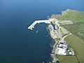
 Carlingford Habour


.jpg)


References
- ↑ Census 2011 - County Louth Overview
- ↑ North West Passage
- ↑ 3.0 3.1 Corry, Eoghan (2005). The GAA Book of Lists. Hodder Headline Ireland. pp. 186–191. ISBN 0-340-89695-7.
- ↑ 4.0 4.1 4.2 http://www.airo.ie/news/census-2011-irish-towns-categorised-population-area-and-change
- ↑ http://census.cso.ie/sapmap2011/Results.aspx?Geog_Type=ST&Geog_Code=35009
- ↑ http://census.cso.ie/sapmap2011/Results.aspx?Geog_Type=ST&Geog_Code=10008
Outside links
| ("Wikimedia Commons" has material about Louth County Louth) |
- Carlingford town local site
- Drogheda Tourism - Official Site of the Drogheda Tourist Office
- Dunleer town portal
- Dunleer Parish
- Omeath town local site
- Tallanstown Tidy Towns
- CSO Louth
| Counties of the Republic of Ireland |
|---|
|
Carlow • Cavan • Clare • Cork • Donegal • Dublin • Galway • Kerry • Kildare • Kilkenny • Laois • Leitrim • Limerick • Longford • Louth • Mayo • Meath • Monaghan • Offaly • Roscommon • Sligo • Tipperary • Waterford • Westmeath • Wexford • Wicklow |