Carmarthenshire
| Carmarthenshire Welsh: Sir Gaerfyddin United Kingdom | |

| |
|---|---|
| Flag | |
| Rhyddid gwerin ffyniant gwlad (A free people a prosperous country) | |

| |
| [Interactive map] | |
| Area: | 1,095 square miles |
| Population: | Template:Hcspop |
| County town: | Carmarthen |
| County flower: | Whorled caraway [1] |
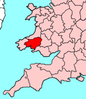
The County of Carmarthen is a maritime shire in the south west of Wales.
Geography
It is bounded to the north by Cardiganshire, to the east by Brecknockshire and Glamorgan, to the south by the Bristol Channel and to the west by Pembrokeshire. It is the largest county in Wales, but only the 28th largest in the whole United Kingdom.
The surface generally is upland and mountainous. Fforest Fawr and the Black Mountain extend into the east of the county and the Cambrian Mountains into the north. The south coast contains many fishing villages and sandy beaches. The highest point is the Fan Brycheiniog at 2,525 feet
The main rivers are the Tywi, the Lougher (which forms the eastern boundary with Glamorgan), and the Gwendraeth Fawr. The principal industries are agriculture, forestry, fishing and tourism.
Towns and villages
Parishes
- Abergwili
- Abernant
- Ammanford
- Betws
- Bronwydd
- Carmarthen
- Cenarth
- Cilycwm
- Cilymaenllwyd
- Cwmamman
- Cynwyl Elfed
- Cynwyl Gaeo
- Dyffryn Cennen
- Eglwyscummin
- Gorslas
- Henllanfallteg
- Kidwelly
- Laugharne Township
- Llanarthney
- Llanboidy
- Llanddarog
- Llanddeusant
- Llanddowror
- Llandeilo
- Llandovery
- Llandybie
- Llandyfaelog
- Llanedi
- Llanegwad
- Llanelli
- Llanelli Rural
- Llanfair-ar-y-bryn
- Llanfihangel Aberbythych
- Llanfihangel-ar-arth
- Llanfihangel Rhos-y-corn
- Llanfynydd
- Llangadog
- Llangain
- Llangathen
- Llangeler
- Llangennech
- Llangunnor
- Llangyndeyrn
- Llangynin
- Llangynog
- Llanllawddog
- Llanllwni
- Llannon
- Llanpumsaint
- Llansadwrn
- Llansawel
- Llansteffan
- Llanwinio
- Llanwrda
- Llanybydder
- Llanycrwys
- Manordeilo and Salem
- Meidrim
- Myddfai
- Newcastle Emlyn
- Newchurch and Merthyr
- Pembrey and Burry Port Town
- Pencarreg
- Pendine
- Pontyberem
- Quarter Bach
- St Clears
- St Ishmael
- Talley
- Trelech
- Trimsaran
- Whitland
This county article is a stub: help to improve Wikishire by building it up.
| Counties of the United Kingdom |
|---|
|
Aberdeen • Anglesey • Angus • Antrim • Argyll • Armagh • Ayr • Banff • Bedford • Berks • Berwick • Brecknock • Buckingham • Bute • Caernarfon • Caithness • Cambridge • Cardigan • Carmarthen • Chester • Clackmannan • Cornwall • Cromarty • Cumberland • Denbigh • Derby • Devon • Dorset • Down • Dumfries • Dunbarton • Durham • East Lothian • Essex • Fermanagh • Fife • Flint • Glamorgan • Gloucester • Hants • Hereford • Hertford • Huntingdon • Inverness • Kent • Kincardine • Kinross • Kirkcudbright • Lanark • Lancaster • Leicester • Lincoln • Londonderry • Merioneth • Middlesex • Midlothian • Monmouth • Montgomery • Moray • Nairn • Norfolk • Northampton • Northumberland • Nottingham • Orkney • Oxford • Peebles • Pembroke • Perth • Radnor • Renfrew • Ross • Roxburgh • Rutland • Selkirk • Shetland • Salop • Somerset • Stafford • Stirling • Suffolk • Surrey • Sussex • Sutherland • Tyrone • Warwick • West Lothian • Westmorland • Wigtown • Wilts • Worcester • York |