County Londonderry: Difference between revisions
No edit summary |
|||
| (11 intermediate revisions by 3 users not shown) | |||
| Line 1: | Line 1: | ||
{{Infobox county | {{Infobox county | ||
|name=County Londonderry | |name=County Londonderry | ||
|map image= | |map image=Londonderry Brit Isles Sect 4.svg | ||
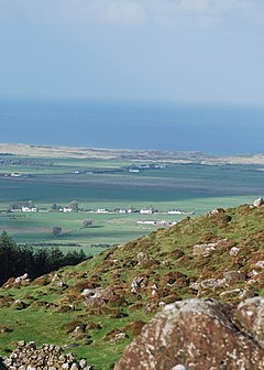
|picture=View from Binevenagh - geograph.org.uk - 1553533.jpg | |picture=View from Binevenagh - geograph.org.uk - 1553533.jpg | ||
|picture caption=Binevenagh looking toward to sea | |picture caption=Binevenagh looking toward to sea | ||
| Line 7: | Line 7: | ||
|county town=[[Londonderry]] | |county town=[[Londonderry]] | ||
}} | }} | ||
The '''County of Londonderry''' is a [[Counties of the United Kingdom|shire]] of [[Northern Ireland]]. | The '''County of Londonderry''', also known as '''Derry''', is a [[Counties of the United Kingdom|shire]] of [[Northern Ireland]]. | ||
Adjoined to the north-west shore of [[Lough Neagh]], the county covers an area of 801 square miles, with a population of approximately | Adjoined to the north-west shore of [[Lough Neagh]], the county covers an area of 801 square miles, with a population of approximately 243,000. | ||
The coast of Londonderry stretches from the eastern shore of [[Lough Foyle]] and across the wind-beaten Atlantic coast to the strands each side of the mouth of the [[River Bann]]. This coastline is a contrast to the rugged coast of Antrim, marked instead by gentle land and long sweeps of sandy beach, such as the deep beach of Magilligan Strand stretching 5½ miles along the shore of Lough Foyle and the seven miles of Benone Beach. | The coast of Londonderry stretches from the eastern shore of [[Lough Foyle]] and across the wind-beaten Atlantic coast to the strands each side of the mouth of the [[River Bann]]. This coastline is a contrast to the rugged coast of Antrim, marked instead by gentle land and long sweeps of sandy beach, such as the deep beach of Magilligan Strand stretching 5½ miles along the shore of Lough Foyle and the seven miles of Benone Beach. | ||
| Line 31: | Line 31: | ||
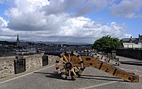
The City of Londonderry was built on the western side of the [[River Foyle]], a strongly walled city as it was at first a frontier town, the stronghold supporting the plantation of the County of Londonderry by settlers from Great Britain. Throughout the conflicts which racked Ulster in the seventeenth and eighteenth century, the city never fell to siege and has thus earned the nickname "The Maiden City". | The City of Londonderry was built on the western side of the [[River Foyle]], a strongly walled city as it was at first a frontier town, the stronghold supporting the plantation of the County of Londonderry by settlers from Great Britain. Throughout the conflicts which racked Ulster in the seventeenth and eighteenth century, the city never fell to siege and has thus earned the nickname "The Maiden City". | ||
In 1688, rebellion against King James II was in the air, and on 5 November William of Orange began his march from [[Brixham]] to [[London]]. King James's Lord Lieutenant of Ireland sent a force to secure the garrison in Londonderry, but on 7 December the city's apprentice boys took matters into their own hands and barred the gates, an event celebrated every year as part of the "Marching Season" by a society maintained for the purpose; the Apprentice Boys of Derry. James fled London later in December and Parliament settled the Crown | In 1688, rebellion against King James II was in the air, and on 5 November William of Orange began his march from [[Brixham]] to [[London]]. King James's Lord Lieutenant of Ireland sent a force to secure the garrison in Londonderry, but on 7 December the city's apprentice boys took matters into their own hands and barred the gates, an event celebrated every year as part of the "Marching Season" by a society maintained for the purpose; the Apprentice Boys of Derry. James fled London later in December and Parliament settled the Crown on William and Mary. James landed in Ireland with a French army the next year and marched on Londonderry and demanded its submission. The city's reply - "No surrender!" - has become part of the loyalist tradition in Ulster. The Siege of Derry was relieved only in July 1689, followed soon by the Battle of [[Newtownbutler]] in [[Fermanagh]], which neutralised James's forces in Ulster. | ||
In 1922 County Londonderry became a frontier again, as neighbouring [[County Donegal]] broke away from the United Kingdom to form part of the Irish Free State. | In 1922 County Londonderry became a frontier again, as neighbouring [[County Donegal]] broke away from the United Kingdom to form part of the Irish Free State. | ||
| Line 39: | Line 39: | ||
===City=== | ===City=== | ||
*[[Londonderry]] | *[[Londonderry]] ([[county town]]) | ||
===Towns=== | ===Towns=== | ||
| Line 53: | Line 53: | ||
*[[Maghera]] | *[[Maghera]] | ||
*[[Newbuildings]] | *[[Newbuildings]] | ||
===Parishes=== | |||
{{parishliststart}} | |||
* [[Aghadowey]] | |||
* [[Aghanloo]] | |||
* [[Agivey]] | |||
* [[Artrea]]<sup>‡</sup> | |||
* [[Ballinderry]]<sup>‡</sup> | |||
* [[Ballyaghran]] | |||
* [[Ballynascreen]] | |||
* [[Ballyrashane]]<sup>†</sup> | |||
* [[Ballyscullion]]<sup>†</sup> | |||
* [[Ballywillin]]<sup>†</sup> | |||
* [[Balteagh]] | |||
* [[Banagher]] | |||
* [[Bovevagh]] | |||
* [[Carrick, County Londonderry|Carrick]] | |||
* [[Clondermot]] | |||
* [[Coleraine]] | |||
* [[Cumber Lower]] | |||
* [[Cumber Upper]]<sup>‡</sup> | |||
* [[Desertlyn]] | |||
* [[Desertmartin]] | |||
* [[Desertoghill]] | |||
* [[Drumachose]] | |||
* [[Dunboe]] | |||
* [[Dungiven]] | |||
* [[Errigal, County Londonderry|Errigal]] | |||
* [[Faughanvale]] | |||
* [[Formoyle]] | |||
* [[Kilcronaghan]] | |||
* [[Kildollagh]]<sup>†</sup> | |||
* [[Killelagh]] | |||
* [[Killowen, County Londonderry|Killowen]] | |||
* [[Kilrea]] | |||
* [[Learmount]]<sup>‡</sup> | |||
* [[Mascosquin]] | |||
* [[Maghera]] | |||
* [[Magherafelt]] | |||
* [[Magilligan]] | |||
* [[Tamlaght, County Londonderry|Tamlaght]]<sup>‡</sup> | |||
* [[Tamlaght Finlagan]] | |||
* [[Tamlaght O'Crilly]] | |||
* [[Templemore, County Londonderry|Templemore]] | |||
* [[Termoneeny]] | |||
{{parishlistend}} | |||
<sup>†</sup>: Extends into [[County Antrim]].<br /><sup>‡</sup>: Extends into [[Tyrone]].<br />Additionally, parts of the parishes of [[Arboe]], [[Ballymoney]], [[Derryloran]], [[Grange of Scullion]] and [[Lissan]] extend into County Londonderry. | |||
==Baronies== | ==Baronies== | ||
*[[Coleraine | *[[Barony of Coleraine|Coleraine]] | ||
*[[Keenaght | *[[Barony of Keenaght|Keenaght]] | ||
*[[North East Liberties of Coleraine]] | *[[North East Liberties of Coleraine]] | ||
*[[North West Liberties of Londonderry]] | *[[North West Liberties of Londonderry]] | ||
| Line 67: | Line 114: | ||
*[[Bellaghy]] Bawn | *[[Bellaghy]] Bawn | ||
*Binevenagh Forest | *Binevenagh Forest | ||
*{{i-NTE}} Downhill Demesne, Castlerock | *{{i-NTE}} [[Downhill Demesne]], Castlerock | ||
**Hezlett House | **Hezlett House | ||
**Mussenden Temple | **Mussenden Temple | ||
| Line 75: | Line 122: | ||
*[[Lough Foyle]] shore | *[[Lough Foyle]] shore | ||
*[[Lough Neagh]] shore | *[[Lough Neagh]] shore | ||
*{{i-NTE}} [ | *{{i-NTE}} [[Springhill House]], a 'Plantation House', at Springhill near [[Magherafelt]] | ||
==References== | ==References== | ||
Latest revision as of 10:44, 3 December 2015
| County Londonderry United Kingdom | |
 Binevenagh looking toward to sea | |
|---|---|

| |
| [Interactive map] | |
| Area: | 816 square miles |
| Population: | 247,971 |
| County seat: | Londonderry |
| County flower: | Purple saxifrage [1] |
The County of Londonderry, also known as Derry, is a shire of Northern Ireland.
Adjoined to the north-west shore of Lough Neagh, the county covers an area of 801 square miles, with a population of approximately 243,000.
The coast of Londonderry stretches from the eastern shore of Lough Foyle and across the wind-beaten Atlantic coast to the strands each side of the mouth of the River Bann. This coastline is a contrast to the rugged coast of Antrim, marked instead by gentle land and long sweeps of sandy beach, such as the deep beach of Magilligan Strand stretching 5½ miles along the shore of Lough Foyle and the seven miles of Benone Beach.
The highest point in the county is the summit of Sawel Mountain in the Sperrins at 2,224 feet, which is on the border with Tyrone and is Tyrone's highest point too. The Sperrin Mountains dominate the southern part of County Londonderry.
To the east and west, the land falls into the valleys of the Bann and Foyle rivers respectively; in the south-east, the county touches the shore of Lough Neagh, which is the largest lake in the British Isles.
The county flower is the purple saxifrage, a cliff-dwelling plant which grows amongst the volcanic rocks of the cliffs at Binevenagh.

History
County Londonderry was a creation of the Plantation of Ulster, though preceding it was County Coleraine, a county absorbed by the new creation. In 1613, King James I granted a charter to the The Honourable The Irish Society to undertake the new county's plantation. The chief place for the endeavour of plantation was the newly founded city of Londonderry, on the site of the old village of Derry. The name "Londonderry" was to recognise the contribution of the London Livery Companies to the Irish Society. The royal charter is dated 29 March 1613,[1] and declared that the "City of Londonderry" and everything contained within the land granted:
| “ |
shall be united, consolidated, and from hence-forth for ever be one entire County of itself, distinct and separate from all our Counties whatsoever within our Kingdom of Ireland-and from henceforth for ever be named, accounted and called, the County of Londonderry.[1] |
” |

The new county took in the then County Coleraine (the baronies of Tirkeeran, Coleraine, and Keenaght; all but the south-west corner of the barony of Loughinsholin, which was then a part of County Tyrone), the North East Liberties of Coleraine (which had been part of County Antrim) and the City and Liberties of Londonderry, which had belonged to County Donegal.[1][2] The liberties of Coleraine and Londonderry were requested by the Irish society so that they could control both banks of the mouths of the River Foyle and the River Bann and have access to sufficient wood for construction.[3]
The City of Londonderry was built on the western side of the River Foyle, a strongly walled city as it was at first a frontier town, the stronghold supporting the plantation of the County of Londonderry by settlers from Great Britain. Throughout the conflicts which racked Ulster in the seventeenth and eighteenth century, the city never fell to siege and has thus earned the nickname "The Maiden City".
In 1688, rebellion against King James II was in the air, and on 5 November William of Orange began his march from Brixham to London. King James's Lord Lieutenant of Ireland sent a force to secure the garrison in Londonderry, but on 7 December the city's apprentice boys took matters into their own hands and barred the gates, an event celebrated every year as part of the "Marching Season" by a society maintained for the purpose; the Apprentice Boys of Derry. James fled London later in December and Parliament settled the Crown on William and Mary. James landed in Ireland with a French army the next year and marched on Londonderry and demanded its submission. The city's reply - "No surrender!" - has become part of the loyalist tradition in Ulster. The Siege of Derry was relieved only in July 1689, followed soon by the Battle of Newtownbutler in Fermanagh, which neutralised James's forces in Ulster.
In 1922 County Londonderry became a frontier again, as neighbouring County Donegal broke away from the United Kingdom to form part of the Irish Free State.
Towns and villages

City
Towns
Larger villages
Parishes
- Aghadowey
- Aghanloo
- Agivey
- Artrea‡
- Ballinderry‡
- Ballyaghran
- Ballynascreen
- Ballyrashane†
- Ballyscullion†
- Ballywillin†
- Balteagh
- Banagher
- Bovevagh
- Carrick
- Clondermot
- Coleraine
- Cumber Lower
- Cumber Upper‡
- Desertlyn
- Desertmartin
- Desertoghill
- Drumachose
- Dunboe
- Dungiven
- Errigal
- Faughanvale
- Formoyle
- Kilcronaghan
- Kildollagh†
- Killelagh
- Killowen
- Kilrea
- Learmount‡
- Mascosquin
- Maghera
- Magherafelt
- Magilligan
- Tamlaght‡
- Tamlaght Finlagan
- Tamlaght O'Crilly
- Templemore
- Termoneeny
†: Extends into County Antrim.
‡: Extends into Tyrone.
Additionally, parts of the parishes of Arboe, Ballymoney, Derryloran, Grange of Scullion and Lissan extend into County Londonderry.
Baronies
- Coleraine
- Keenaght
- North East Liberties of Coleraine
- North West Liberties of Londonderry
- Loughinsholin
- Tirkeeran
Things to see in County Londonderry
| Key | |
| Cathedral/Abbey/Priory | |
| Accessible open space | |
| Amusement/Theme Park | |
| Castle | |
| Country Park | |
| State Care | |
| Forestry Commission | |
| Heritage railway | |
| Historic House | |
| Museum (free/not free) | |
| National Trust | |
| Zoo | |

- Bellaghy Bawn
- Binevenagh Forest
 Downhill Demesne, Castlerock
- Hezlett House
- Mussenden Temple
- Forest of Banagher
 Gray's Printing Press, Strabane
- Londonderry City Walls
- Lough Foyle shore
- Lough Neagh shore
 Springhill House, a 'Plantation House', at Springhill near Magherafelt
References
| ("Wikimedia Commons" has material about County Londonderry) |
- ↑ 1.0 1.1 1.2 Notes on the Place Names of the Parishes and Townlands of the County of Londonderry, 1925, Alfred Moore Munn, Clerk of the Crown and Peace of the City and County of Londonderry
- ↑ - A New History of Ireland, pages 111-112
- ↑ Curl, James Stevens (2001). "The City of London and the Plantation of Ulster". BBCi History Online. http://www.bbc.co.uk/history/british/plantation/companies/londoncompanies_full.rtf. Retrieved 2008-08-10.
| Counties of the United Kingdom |
|---|
|
Aberdeen • Anglesey • Angus • Antrim • Argyll • Armagh • Ayr • Banff • Bedford • Berks • Berwick • Brecknock • Buckingham • Bute • Caernarfon • Caithness • Cambridge • Cardigan • Carmarthen • Chester • Clackmannan • Cornwall • Cromarty • Cumberland • Denbigh • Derby • Devon • Dorset • Down • Dumfries • Dunbarton • Durham • East Lothian • Essex • Fermanagh • Fife • Flint • Glamorgan • Gloucester • Hants • Hereford • Hertford • Huntingdon • Inverness • Kent • Kincardine • Kinross • Kirkcudbright • Lanark • Lancaster • Leicester • Lincoln • Londonderry • Merioneth • Middlesex • Midlothian • Monmouth • Montgomery • Moray • Nairn • Norfolk • Northampton • Northumberland • Nottingham • Orkney • Oxford • Peebles • Pembroke • Perth • Radnor • Renfrew • Ross • Roxburgh • Rutland • Selkirk • Shetland • Salop • Somerset • Stafford • Stirling • Suffolk • Surrey • Sussex • Sutherland • Tyrone • Warwick • West Lothian • Westmorland • Wigtown • Wilts • Worcester • York |
