Herefordshire: Difference between revisions
mNo edit summary |
|||
| (10 intermediate revisions by 3 users not shown) | |||
| Line 3: | Line 3: | ||
|picture=Pembridge, Market Hall and New Inn. - geograph.org.uk - 149878.jpg| | |picture=Pembridge, Market Hall and New Inn. - geograph.org.uk - 149878.jpg| | ||
|picture caption=Pembridge | |picture caption=Pembridge | ||
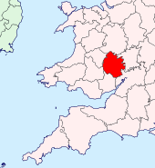
|map image= | |map image=Herefordshire Brit Isles Sect 6.svg | ||
|county town=[[Hereford]] | |county town=[[Hereford]] | ||
}} | }} | ||
The '''County of Hereford''' is a [[Counties of the United Kingdom|shire]], a rural county and the only county of [[England]] entirely west of the [[River Severn]]. It is also possibly England's most rural county and most sparsely populated with a population density of 212 a square mile; indeed it is said that outside [[Hereford]] and [[Leominster]] the population has not increased since the Middle Ages. The hills are rugged green pasture, with deep river valleys along which the shire's villages are found. | The '''County of Hereford''' is a [[Counties of the United Kingdom|shire]], a rural county and the only county of [[England]] entirely west of the [[River Severn]]. It is also possibly England's most rural county and one of the most sparsely populated with a population density of 212 a square mile; indeed it is said that outside [[Hereford]] and [[Leominster]] the population has not increased since the Middle Ages. The hills are rugged green pasture, with deep river valleys along which the shire's villages are found. | ||
The county has borders with six other shires; [[Monmouthshire]], [[Brecknockshire]] and [[Radnorshire]] to the west, [[Shropshire]] to the north, [[Worcestershire]] eastward and [[Gloucestershire]] to it south. As such, it stands between the Welsh mountains and the Midland plains and is itself a rich mixture of both. The land of Herefordshire is predominantly agricultural and the county is well known for Hereford cattle and for its fruit and cider production. | The county has borders with six other shires; [[Monmouthshire]], [[Brecknockshire]] and [[Radnorshire]] to the west, [[Shropshire]] to the north, [[Worcestershire]] eastward and [[Gloucestershire]] to it south. As such, it stands between the Welsh mountains and the Midland plains and is itself a rich mixture of both. The land of Herefordshire is predominantly agricultural and the county is well known for Hereford cattle and for its fruit and cider production. | ||
| Line 17: | Line 15: | ||
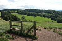
[[File:Dorstone Hill - geograph.org.uk - 45985.jpg|right|thumb|200px|Dorstone Hill]] | [[File:Dorstone Hill - geograph.org.uk - 45985.jpg|right|thumb|200px|Dorstone Hill]] | ||
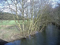
[[File:The River Arrow, near Titley - geograph.org.uk - 361216.jpg|right|thumb|200px|The River Arrow near Titley]] | [[File:The River Arrow, near Titley - geograph.org.uk - 361216.jpg|right|thumb|200px|The River Arrow near Titley]] | ||
The foothills of Brecknockshire's Black Mountains begin in western Herefordshire, some standing at 2,000 feet. East of them the land rises in a number of great northwest-southeast folds, including the famous [[Golden Valley]]. The very east of the county rises into the whaleback of the [[ | The foothills of Brecknockshire's Black Mountains begin in western Herefordshire, some standing at 2,000 feet. East of them the land rises in a number of great northwest-southeast folds, including the famous [[Golden Valley]]. The very east of the county rises into the whaleback of the [[Malvern Hills]], forming the boundary with Worcestershire. | ||
The major river of Herefordshire is the Wye, which runs from Clifford next to the bounds of Radnorshire down to Hereford then writhes toward Ross-on-Wye before running out of the county. The Wye in its lower Herefordshire reaches is a broad, calm stream passing fields and hamlets. There are still coracle fishermen on the Wye. | The major river of Herefordshire is the Wye, which runs from Clifford next to the bounds of Radnorshire down to Hereford then writhes toward Ross-on-Wye before running out of the county. The Wye in its lower Herefordshire reaches is a broad, calm stream passing fields and hamlets. There are still coracle fishermen on the Wye. | ||
| Line 24: | Line 22: | ||
==History== | ==History== | ||
Iron | Iron Age hill fort are found across the hills of Herefordshire telling of a long, if unsettled, past in these hills and valleys. The known history begins somewhat later. | ||
===Early Mediæval=== | ===Early Mediæval=== | ||
The seventh century ''Tribal Hidage'' of the Kingdom of the Mercians lists the westerly province of the ''Magonsæte'', which later became or formed the heart of Herefordshire. Place-name evidence and dialectical evidence suggests that these ''Magonsæte'' were not purely English but seem to have absorbed some native Britons (Welsh). The mixed nature of Herefordshire on the boundaries of the Welsh kingdoms and lordships has been a constant factor in the nature of the county. The old name survives in writing long after the shire was created, for example in 1016 the Eadric Streona order the county ''fyrd'' of the ''Magesætan'' to flee in battle.<ref>Anglo-Saxon Chronicle (Peterborough Chronicle) 1016 ''Þa dyde Eadric ealdorman swa swa he ær ofter dyde, astealde þæne fleam ærast mid Magesætan''</ref> | The seventh-century ''Tribal Hidage'' of the Kingdom of the Mercians lists the westerly province of the ''Magonsæte'', which later became or formed the heart of Herefordshire. Place-name evidence and dialectical evidence suggests that these ''Magonsæte'' were not purely English but seem to have absorbed some native Britons (Welsh). The mixed nature of Herefordshire on the boundaries of the Welsh kingdoms and lordships has been a constant factor in the nature of the county. The old name survives in writing long after the shire was created, for example in 1016 the Eadric Streona order the county ''fyrd'' of the ''Magesætan'' to flee in battle.<ref>Anglo-Saxon Chronicle (Peterborough Chronicle) 1016 ''Þa dyde Eadric ealdorman swa swa he ær ofter dyde, astealde þæne fleam ærast mid Magesætan''</ref> | ||
The [[Diocese of Hereford]] was founded in 676 and this formed a solid presence which dominated the social structure of Herefordshire thereafter. | The [[Diocese of Hereford]] was founded in 676 and this formed a solid presence which dominated the social structure of Herefordshire thereafter. | ||
In the 8th century Offa King of the Mercians fixed the Mercian frontier with the Welsh in the west of Herefordshire, at the [[River Wye]] and a long earthwork, Offa's Dyke, which survives. Another defensive earthwork, Rowe Ditch, stands across the Arrow Valley. | In the 8th century Offa King of the Mercians fixed the Mercian frontier with the Welsh in the west of Herefordshire, at the [[River Wye]] and a long earthwork, [[Offa's Dyke]], which survives. Another defensive earthwork, Rowe Ditch, stands across the [[River Arrow, Herefordshire|Arrow Valley]]. | ||
===Danish and Norman control=== | ===Danish and Norman control=== | ||
| Line 60: | Line 58: | ||
Hops were grown in Herefordshire soon after their introduction into England in 1524. In 1580 and again in 1637 the county was severely visited by the plague, but in the 17th century it had a flourishing timber trade, and was also noted for its orchards and cider. | Hops were grown in Herefordshire soon after their introduction into England in 1524. In 1580 and again in 1637 the county was severely visited by the plague, but in the 17th century it had a flourishing timber trade, and was also noted for its orchards and cider. | ||
== | ==Geography== | ||
[[File:Herefordshire Hundreds.svg|thumb|200px|The hundreds of Herefordshire]] | |||
[[File:Hereford Cathedral, from Church Street.jpg|right|thumb|200px|Hereford]] | [[File:Hereford Cathedral, from Church Street.jpg|right|thumb|200px|Hereford]] | ||
[[File:Broad Street, Weobley, Herefordshire - geograph.org.uk - 12581.jpg|right|thumb|200px|Weobley]] | [[File:Broad Street, Weobley, Herefordshire - geograph.org.uk - 12581.jpg|right|thumb|200px|Weobley]] | ||
Herefordshire is a compact county, but it has several detached parts in the surrounding shires, and three counties have detached parts within it: | |||
* The townships of [[Fwthog]] and [[Bwlch Trewyn]] (both in the ancient parish of [[Cwmyoy]]) are detached in Monmouthshire, the latter only by the [[River Monnow]]. There is also the curious case of the Crooked Billet: a three-acre field in [[Newchurch, Monmouthshire|Newchurch]] parish that is part of Herefordshire. | |||
* The township of [[Litton and Cascob]] (in both [[Cascob]] and [[Presteigne]] parishes) lies in [[Radnorshire]]. | |||
* The chapelry of [[Farlow]] (in the ancient parish of [[Stottesden]]) lies in [[Shropshire]] | |||
* The parish of [[Rochford, Herefordshire|Rochford]] is detached in [[Worcestershire]]. | |||
* The ancient parish of [[Edvin Loach]] (in three parts) is a portion of [[Worcestershire]] detached in Herefordshire. | |||
* The township of Lower Lea (in the ancient parish of [[Lea, Herefordshire|Lea]]) forms part of [[Gloucestershire]], one part of which is detached in Herefordshire. | |||
* One of the many detached parts of the Gloucestershire tything of Lea Bailey lies insulated from its parent county in Herefordshire. | |||
* The ancient parish of [[Welsh Bicknor]] is a part of Monmouthshire, detached in Herefordshire. | |||
===Hundreds=== | |||
The county has 11 hundreds: | |||
*[[Broxash]] | |||
*[[Ewyas Lacy]] | |||
*[[Greytree]] | |||
*[[Grimsworth]] | |||
*[[Huntington Hundred|Huntington]] | |||
*[[Radlow]] | |||
*[[Stretford Hundred|Stretford]] | |||
*[[Webtree]] | |||
*[[Wigmore Hundred|Wigmore]] | |||
*[[Wolphy]] | |||
*[[Wormelow]] | |||
===Towns and villages=== | |||
The towns in the county are: | The towns in the county are: | ||
| Line 70: | Line 94: | ||
*[[Ross-on-Wye]] | *[[Ross-on-Wye]] | ||
*[[Kington, Herefordshire|Kington]] | *[[Kington, Herefordshire|Kington]] | ||
*[[Bromyard]] | *[[Bromyard]] | ||
Herefordshire has many scattered villages, mainly in the valleys which its rivers cut through the hills. | Herefordshire has many scattered villages, mainly in the valleys which its rivers cut through the hills. | ||
| Line 99: | Line 123: | ||
==Places of interest== | ==Places of interest== | ||
{{UKPlacesKey | {{UKPlacesKey}} | ||
*{{i-House}} Abbey Dore Court | *{{i-House}} [[Abbey Dore Court]] | ||
*{{i-House}} {{i-NTE}} Berrington Hall | *{{i-House}} {{i-NTE}} [[Berrington Hall]] | ||
*Courtyard Centre for the Arts, Hereford | *Courtyard Centre for the Arts, Hereford | ||
*Croft Castle | *[[Croft Castle]] | ||
*{{i-Abbey}} Dore Abbey | *{{i-Abbey}} [[Dore Abbey]] | ||
*{{i-House}} Eastnor Castle | *{{i-House}} [[Eastnor Castle]] | ||
*{{i-House}} Eye Manor | *{{i-House}} [[Eye Manor]] | ||
*Goodrich Castle | *[[Goodrich Castle]] | ||
*{{i-House}} Hampton Court | *{{i-House}} [[Hampton Court, Herefordshire|Hampton Court]] | ||
*{{i-House}} [[Hellens]] | *{{i-House}} [[Hellens Manor]] | ||
*{{i-Cathedral}} [[Hereford]] | *{{i-Cathedral}} [[Hereford Cathedral]] | ||
*{{i-OpenSpace}} Malvern Hills | *{{i-OpenSpace}} [[Malvern Hills]] | ||
*Herefordshire Beacon | *[[Herefordshire Beacon]] | ||
*{{i-Abbey}} Priory Church, [[Leominster]] | *{{i-Abbey}} Priory Church, [[Leominster]] | ||
*Sutton Walls Hill Fort | *[[Sutton Walls Hill Fort]] | ||
{{clear}} | {{clear}} | ||
==Outside links== | |||
*[http://www.earthheritagetrust.org Herefordshire & Worcestershire Earth Heritage Trust] | |||
*[http://www.myherefordshire.com Herefordshire County Portal] Local events, jobs, photos and news | |||
==References== | ==References== | ||
{{Reflist}} | {{Reflist}} | ||
{{British county}} | {{British county}} | ||
Latest revision as of 13:48, 16 February 2024
| Herefordshire United Kingdom | |
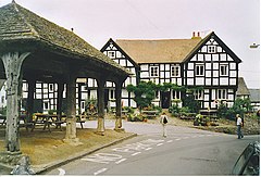 Pembridge | |
|---|---|

| |
| Flag | |
| Pulchra Terra Dei Donum (This fair land is the gift of God) | |
| |
| [Interactive map] | |
| Area: | 837 square miles |
| Population: | 183,631 |
| County town: | Hereford |
| County flower: | Mistletoe [1] |
The County of Hereford is a shire, a rural county and the only county of England entirely west of the River Severn. It is also possibly England's most rural county and one of the most sparsely populated with a population density of 212 a square mile; indeed it is said that outside Hereford and Leominster the population has not increased since the Middle Ages. The hills are rugged green pasture, with deep river valleys along which the shire's villages are found.
The county has borders with six other shires; Monmouthshire, Brecknockshire and Radnorshire to the west, Shropshire to the north, Worcestershire eastward and Gloucestershire to it south. As such, it stands between the Welsh mountains and the Midland plains and is itself a rich mixture of both. The land of Herefordshire is predominantly agricultural and the county is well known for Hereford cattle and for its fruit and cider production.
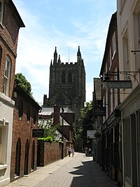
The county town, and the largest town of the county is the City of Hereford, a cathedral city of some 55,700 inhabitants it is also the only town of any great size. Hereford, standing on the banks of the Wye, is dominated by its imposing mediæval cathedral, out of proportion to the small city itself; an impressive edifice to the glory of God in the midst of a land shaped by His hand.
Landscape
The foothills of Brecknockshire's Black Mountains begin in western Herefordshire, some standing at 2,000 feet. East of them the land rises in a number of great northwest-southeast folds, including the famous Golden Valley. The very east of the county rises into the whaleback of the Malvern Hills, forming the boundary with Worcestershire.
The major river of Herefordshire is the Wye, which runs from Clifford next to the bounds of Radnorshire down to Hereford then writhes toward Ross-on-Wye before running out of the county. The Wye in its lower Herefordshire reaches is a broad, calm stream passing fields and hamlets. There are still coracle fishermen on the Wye.
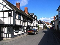
Herefordshire is famous for its "black and white villages" of pied half-timbered cottages.
History
Iron Age hill fort are found across the hills of Herefordshire telling of a long, if unsettled, past in these hills and valleys. The known history begins somewhat later.
Early Mediæval
The seventh-century Tribal Hidage of the Kingdom of the Mercians lists the westerly province of the Magonsæte, which later became or formed the heart of Herefordshire. Place-name evidence and dialectical evidence suggests that these Magonsæte were not purely English but seem to have absorbed some native Britons (Welsh). The mixed nature of Herefordshire on the boundaries of the Welsh kingdoms and lordships has been a constant factor in the nature of the county. The old name survives in writing long after the shire was created, for example in 1016 the Eadric Streona order the county fyrd of the Magesætan to flee in battle.[1]
The Diocese of Hereford was founded in 676 and this formed a solid presence which dominated the social structure of Herefordshire thereafter.
In the 8th century Offa King of the Mercians fixed the Mercian frontier with the Welsh in the west of Herefordshire, at the River Wye and a long earthwork, Offa's Dyke, which survives. Another defensive earthwork, Rowe Ditch, stands across the Arrow Valley.
Danish and Norman control
In 915 a Viking raid struck up the Severn to the district of Archenfield, on the borders, where they took prisoner Cyfeiliawg, Bishop of Llandaff, and in 921 they besieged Wigmore, which had been rebuilt in that year by King Edward. Trouble between the English and the Welsh kings resumed after the Viking threat had gone. King Edward the Confessor invited Norman soldiers to build castles in the west of the county, notably at Richard's Castle and raised a Breton, known to history as Ralph the Timid, as Earl of Hereford. Hereford was sacked by Gruffudd ap Llywelyn of Gwynedd, beginning a campaign in which Harold Godwinesson, later King Harold II, subjugated all Wales.
William the Conqueror found the county already garrisoned by Normans and Bretons but the land was unquiet and William Fitz Osbern, appointed Earl of Hereford, was forced to put down resistance led by Eadric the Wild and the Welsh princes.
Later Middle Ages
During "The Anarchy", the prolonged civil war of Stephen's reign, Hereford Castle and Weobley castle were held for Matilda against the King, but were captured in 1138. Edward, afterwards Edward I, was imprisoned in Hereford Castle, and thence made his famous escape in 1265. In 1326, Parliament assembled at Hereford and there deposed King Edward II. In the 14th and 15th centuries the forest of Deerfold gave refuge to some of the most noted followers of Wycliffe.
During the Wars of the Roses the influence of the Mortimers led the county to support the House of York, and Edward, afterwards Edward IV, raised 23,000 men in this neighbourhood. The Battle of Mortimer's Cross was fought in 1461 near Wigmore.
Modern Period
Before the outbreak of the civil war of the 17th century, complaints of illegal taxation were rife in Herefordshire, but a strong anti-puritan feeling induced the county to favour the royalist cause. Hereford, Goodrich and Ledbury all endured sieges.
Earls of Hereford
King Edward the Confessor granted the Earldom of Hereford to his cousin, a Norman nobleman named Ralph of Mantes, whose mother and wife were English though he brought many Normans in his retinue. As Earl, Ralph, known to history as Ralph the Timid, held a functional public office and not a title of nobility as such, for he had the duty of building castles and defending the frontier, in which he singularly failed and died in 1057.
The earldom of Hereford was granted by King William I to William FitzOsbern, about 1067, but on the outlawry of his son Roger in 1074 the title lapsed until conferred on Henry de Bohun about 1199. It remained in the possession of the de Bohuns until the death of Humphrey de Bohun, 7th Earl of Hereford in 1373; in 1397 Henry, Earl of Derby, who had married Mary de Bohun, was created Duke of Hereford, a title by which he is known in Shakespeare's Richard II, though the title merged in the Crown when Henry overthrew Richard II and became the first king of the House of Lancaster.
In 1550, Edward VI ennobled Walter Devereux, a descendant of the de Bohun family, as Viscount Hereford, and his grandson, the famous Earl of Essex, was born in the county. Since this date the title of Viscount Hereford has been held by the Devereux family, and the holder ranks as the premier viscount of England.
The families of Clifford, Giffard and Mortimer figured prominently in the warfare on the Welsh border, and the Talbots, Lacys, Crofts and Scudamores all had important seats in the county, Sir James Scudamore of Holme Lacy being the original of the Sir Scudamore of Spenser's Faerie Queene. Sir John Oldcastle, the leader of the Lollards, was sheriff of Herefordshire in 1406.
Economy
Herefordshire has always been esteemed an exceptionally rich agricultural area, the manufactures being unimportant, with the sole exception of the woollen and the cloth trade which flourished soon after the Conquest. Iron was worked in Wormelow hundred in Roman times, and the Domesday Survey mentions iron workers in Marcle. At the time of King Henry VIII the towns had become much impoverished, and under Queen Elizabeth in order to encourage local industries, Parliament insisted that subjects wear English-made woollen caps which came from the workshops of Hereford.
Hops were grown in Herefordshire soon after their introduction into England in 1524. In 1580 and again in 1637 the county was severely visited by the plague, but in the 17th century it had a flourishing timber trade, and was also noted for its orchards and cider.
Geography
Herefordshire is a compact county, but it has several detached parts in the surrounding shires, and three counties have detached parts within it:
- The townships of Fwthog and Bwlch Trewyn (both in the ancient parish of Cwmyoy) are detached in Monmouthshire, the latter only by the River Monnow. There is also the curious case of the Crooked Billet: a three-acre field in Newchurch parish that is part of Herefordshire.
- The township of Litton and Cascob (in both Cascob and Presteigne parishes) lies in Radnorshire.
- The chapelry of Farlow (in the ancient parish of Stottesden) lies in Shropshire
- The parish of Rochford is detached in Worcestershire.
- The ancient parish of Edvin Loach (in three parts) is a portion of Worcestershire detached in Herefordshire.
- The township of Lower Lea (in the ancient parish of Lea) forms part of Gloucestershire, one part of which is detached in Herefordshire.
- One of the many detached parts of the Gloucestershire tything of Lea Bailey lies insulated from its parent county in Herefordshire.
- The ancient parish of Welsh Bicknor is a part of Monmouthshire, detached in Herefordshire.
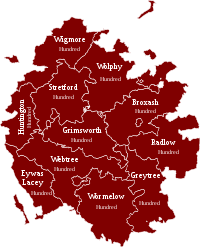
Hundreds
The county has 11 hundreds:
Towns and villages
The towns in the county are:
Herefordshire has many scattered villages, mainly in the valleys which its rivers cut through the hills.
Employment
Most employment in Herefordshire is in agriculture, manufacturing and services. Cargill Meats and H.P Bulmers are two of the largest employers.
The agricultural economy of Herefordshire has suffered challenges in recent years as elsewhere but remains dominant throughout most of the county, in particular pastoral farms, the arable farms lying mainly in the shire's lower-lying east.
Beef
Probably Hereford's most famous export is its beef cattle Hereford cattle. Herefords are docile but extremely hardy creatures and these attributes have led to their proliferation across the world, particularly the Americas and Australia. The breed is so gentle that a Hereford bull has been used as the mascot for Hereford United Football Club for many years, led around packed stadiums before major matches.
Fruit
The county is famous for its apple and pear orchards, and its cider. There are many orchards around the county but not as many as there once were.
In the last few years, soft fruits such as strawberries have become a new and rapidly expanding area of the agricultural economy of the county. One of the main reasons for this was the introduction of the polytunnel or French tunnel. This allowed the strawberries to be grown for a far longer season and at a higher quality (with no blemishes from the rain). The strawberries are mainly picked by Eastern European workers who come over for the season to earn some money, more than they could working in their country of origin and with the bonus, for many of them, of learning or improving their English fluency. The polytunnels have been a major issue in the county, as some people see them as a "blot on the landscape".[2]
Dairy
There was a time when the majority of farms in the county would have had dairy cattle for milk production. The cost of investing in new equipment, long hours, BSE, foot-and-mouth disease and mainly the falling milk prices have meant that the milk production has drastically fallen.
Potatoes
The soils of Herefordshire are mostly marl, meaning that large scale potato production was very difficult, as tractors were not powerful enough to pull the large machinery required to harvest the crop. Around the early 1990s new technology and more powerful machines overcame this problem. Potato production started to increase, fuelled by a few other key factors: The previously pastoral soils had not had potatoes grown in them; consequently they were not infected with eelworm (Heterodera rostochiensis and Heterodera pallida), which in the east of England had to be sprayed against weekly (a large cost). Also, the clay soil produced an unblemished potato of the highest grade.
The intensive nature of the potato crop meant that potatoes could be grown viably on a given field in only one of every five years. Because potato growers always needed more land than they owned, they rented extra. This demand for rental fields came at a time when the rest of the industry was struggling and in serious decline.
County flower
As part of a competition organised by the charity Plantlife to raise awareness of conservation issues, the public were asked to vote for a county flower that they felt best represented their county. Mistletoe was announced as the winning choice for Herefordshire in 2004.[3]
Places of interest
| Key | |
| Cathedral/Abbey/Priory | |
| Accessible open space | |
| Amusement/Theme Park | |
| Castle | |
| Country Park | |
| English Heritage | |
| Forestry Commission | |
| Heritage railway | |
| Historic House | |
| Museum (free/not free) | |
| National Trust | |
| Zoo | |
 Abbey Dore Court
 Berrington Hall
- Courtyard Centre for the Arts, Hereford
- Croft Castle
 Dore Abbey
 Eastnor Castle
 Eye Manor
- Goodrich Castle
 Hampton Court
 Hellens Manor
 Hereford Cathedral
 Malvern Hills
- Herefordshire Beacon
 Priory Church, Leominster
- Sutton Walls Hill Fort
Outside links
- Herefordshire & Worcestershire Earth Heritage Trust
- Herefordshire County Portal Local events, jobs, photos and news
References
- ↑ Anglo-Saxon Chronicle (Peterborough Chronicle) 1016 Þa dyde Eadric ealdorman swa swa he ær ofter dyde, astealde þæne fleam ærast mid Magesætan
- ↑ "CPC — Press". Polytunnelcontrol.org.uk. http://www.polytunnelcontrol.org.uk/press.htm. Retrieved 2010-09-25.
- ↑ Kirby, Alex (2004-05-05). "''UK counties choose floral emblems'', BBC News online, accessed October 31, 2007". BBC News. http://news.bbc.co.uk/2/hi/science/nature/3684291.stm. Retrieved 2010-09-25.
| Counties of the United Kingdom |
|---|
|
Aberdeen • Anglesey • Angus • Antrim • Argyll • Armagh • Ayr • Banff • Bedford • Berks • Berwick • Brecknock • Buckingham • Bute • Caernarfon • Caithness • Cambridge • Cardigan • Carmarthen • Chester • Clackmannan • Cornwall • Cromarty • Cumberland • Denbigh • Derby • Devon • Dorset • Down • Dumfries • Dunbarton • Durham • East Lothian • Essex • Fermanagh • Fife • Flint • Glamorgan • Gloucester • Hants • Hereford • Hertford • Huntingdon • Inverness • Kent • Kincardine • Kinross • Kirkcudbright • Lanark • Lancaster • Leicester • Lincoln • Londonderry • Merioneth • Middlesex • Midlothian • Monmouth • Montgomery • Moray • Nairn • Norfolk • Northampton • Northumberland • Nottingham • Orkney • Oxford • Peebles • Pembroke • Perth • Radnor • Renfrew • Ross • Roxburgh • Rutland • Selkirk • Shetland • Salop • Somerset • Stafford • Stirling • Suffolk • Surrey • Sussex • Sutherland • Tyrone • Warwick • West Lothian • Westmorland • Wigtown • Wilts • Worcester • York |