Cardiganshire: Difference between revisions
No edit summary |
|||
| Line 1: | Line 1: | ||
{{Infobox county | {{Infobox county | ||
|name=Cardiganshire | |name=Cardiganshire | ||
|welsh=Sir Aberteifi | |welsh=Sir Aberteifi or Ceredigion | ||
|map image=CardiganshireBrit6.PNG | |map image=CardiganshireBrit6.PNG | ||
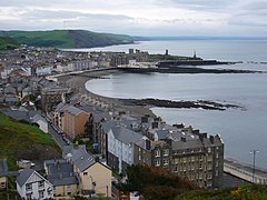
|picture=Aberystwyth from Constitution hill 1.JPG | |picture=Aberystwyth from Constitution hill 1.JPG | ||
|picture caption=Aberystwyth | |picture caption=Aberystwyth | ||
|area=815 square miles | |area=815 square miles | ||
|population= | |population={{hcspop|18}} | ||
|county town=[[Cardigan]] | |county town=[[Cardigan]] | ||
|flower=Bog-rosemary | |flower=Bog-rosemary | ||
}} | }} | ||
'''Cardiganshire''' is a costal [[Counties of the United Kingdom|county]] on the west coast of Wales, bounded on the west by [[Cardigan Bay]], part of the [[Irish Sea]], but away from the county's narrow coastal plain Cardiganshire rises up into mountains. | '''Cardiganshire''' is a costal [[Counties of the United Kingdom|county]] on the west coast of Wales, bounded on the west by [[Cardigan Bay]], part of the [[Irish Sea]], but away from the county's narrow coastal plain Cardiganshire rises up into mountains. | ||
==Geography== | ==Geography== | ||
It is bordered by [[Cardigan Bay]] to the west, [[ | It is bordered by [[Cardigan Bay]] to the west, [[Merionethshire]] to the north, [[Montgomeryshire]], [[Radnorshire]] and [[Brecknockshire]] to the east, [[Carmarthenshire]] to the south, and [[Pembrokeshire]] to the south-west. | ||
The [[Cambrian Mountains]] cover much of the east of the county. In the south and west the surface is less elevated. The highest point is [[Plynlimon]] at 2,467 ft, where five rivers have their source: the [[River Severn]], the [[River Wye]], the [[River Dulas]], the [[River Llyfnant]] and the [[River Rheidol]], the last of which meets the [[Afon Mynach]] in a 300-ft plunge at the [[Devil's Bridge]] chasm. The 50 miles of coastline has many sandy beaches. The largest river is the [[River Teifi]] which forms the border with Carmarthenshire and Pembrokeshire for part of its length. Other significant rivers include the [[River Aeron]] which has its estuary at [[Aberaeron]], the [[River Ystwyth]] and the [[River Rheidol]] both of which reach the sea in [[Aberystwyth]] [[Harbor|harbour]]. | The [[Cambrian Mountains]] cover much of the east of the county. In the south and west the surface is less elevated. The highest point is [[Plynlimon]] at 2,467 ft, where five rivers have their source: the [[River Severn]], the [[River Wye]], the [[River Dulas]], the [[River Llyfnant]] and the [[River Rheidol]], the last of which meets the [[Afon Mynach]] in a 300-ft plunge at the [[Devil's Bridge]] chasm. The 50 miles of coastline has many sandy beaches. The largest river is the [[River Teifi]] which forms the border with Carmarthenshire and Pembrokeshire for part of its length. Other significant rivers include the [[River Aeron]] which has its estuary at [[Aberaeron]], the [[River Ystwyth]] and the [[River Rheidol]] both of which reach the sea in [[Aberystwyth]] [[Harbor|harbour]]. | ||
Revision as of 12:44, 17 August 2010
| Cardiganshire Welsh: Sir Aberteifi or Ceredigion United Kingdom | |
 Aberystwyth | |
|---|---|
| Golud Gwlad Rhyddid (A nation's wealth is freedom) | |

| |
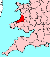
| [Interactive map] | |
| Area: | 815 square miles |
| Population: | Template:Hcspop |
| County town: | Cardigan |
| County flower: | Bog-rosemary [1] |
Cardiganshire is a costal county on the west coast of Wales, bounded on the west by Cardigan Bay, part of the Irish Sea, but away from the county's narrow coastal plain Cardiganshire rises up into mountains.
Geography
It is bordered by Cardigan Bay to the west, Merionethshire to the north, Montgomeryshire, Radnorshire and Brecknockshire to the east, Carmarthenshire to the south, and Pembrokeshire to the south-west.
The Cambrian Mountains cover much of the east of the county. In the south and west the surface is less elevated. The highest point is Plynlimon at 2,467 ft, where five rivers have their source: the River Severn, the River Wye, the River Dulas, the River Llyfnant and the River Rheidol, the last of which meets the Afon Mynach in a 300-ft plunge at the Devil's Bridge chasm. The 50 miles of coastline has many sandy beaches. The largest river is the River Teifi which forms the border with Carmarthenshire and Pembrokeshire for part of its length. Other significant rivers include the River Aeron which has its estuary at Aberaeron, the River Ystwyth and the River Rheidol both of which reach the sea in Aberystwyth harbour.
Along with Pembrokeshire and Cornwall, Cardiganshire's 50 miles of coastline boasts some of the whitest sand beaches and cleanest, clearest, turquoise seas in the United Kingdom, particularly the coast from New Quay to Aberporth, mainly due to the fact that the Cardigan Bay coast has virtually no industrial discharge. As a result, Cardiganshire has the only permanent summer residence of bottle-nosed dolphins in the United Kingdom.
Towns and villages
Parishes
- Aberaeron
- Aberporth
- Aberteifi
- Aberystwyth
- Beulah
- Blaenrheidol
- Borth
- Ceulanamaesmawr
- Ciliau Aeron
- Dyffryn Arth
- Faenor
- Geneu'r Glyn
- Henfynyw
- Lampeter
- Llanarth
- Llanbadarn Fawr
- Llanddewibrefi
- Llandyfriog
- Llandysiliogogo
- Llandysul
- Llanfair Clydogau
- Llanfarian
- Llanfihangel Ystrad
- Llangeitho
- Llangoedmor
- Llangrannog
- Llangwyryfon
- Llangybi
- Llangynfelyn
- Llanilar
- Llanllwchaiarn
- Llanrhystyd
- Llansantffraed
- Llanwenog
- Llanwnnen
- Lledrod
- Melindwr
- Nantcwnlle
- New Quay
- Penbryn
- Pontarfynach
- Tirymynach
- Trawsgoed
- Trefeurig
- Tregaron
- Troedyraur
- Y Ferwig
- Ysbyty Ystwyth
- Ysgubor-y-coed
- Ystrad Fflur
- Ystradmeurig
This county article is a stub: help to improve Wikishire by building it up.
| Counties of the United Kingdom |
|---|
|
Aberdeen • Anglesey • Angus • Antrim • Argyll • Armagh • Ayr • Banff • Bedford • Berks • Berwick • Brecknock • Buckingham • Bute • Caernarfon • Caithness • Cambridge • Cardigan • Carmarthen • Chester • Clackmannan • Cornwall • Cromarty • Cumberland • Denbigh • Derby • Devon • Dorset • Down • Dumfries • Dunbarton • Durham • East Lothian • Essex • Fermanagh • Fife • Flint • Glamorgan • Gloucester • Hants • Hereford • Hertford • Huntingdon • Inverness • Kent • Kincardine • Kinross • Kirkcudbright • Lanark • Lancaster • Leicester • Lincoln • Londonderry • Merioneth • Middlesex • Midlothian • Monmouth • Montgomery • Moray • Nairn • Norfolk • Northampton • Northumberland • Nottingham • Orkney • Oxford • Peebles • Pembroke • Perth • Radnor • Renfrew • Ross • Roxburgh • Rutland • Selkirk • Shetland • Salop • Somerset • Stafford • Stirling • Suffolk • Surrey • Sussex • Sutherland • Tyrone • Warwick • West Lothian • Westmorland • Wigtown • Wilts • Worcester • York |