Llanfihangel Ystrad
Jump to navigation
Jump to search
| Llanfihangel_Ystrad | |
| Cardiganshire | |
|---|---|
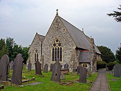
 St Michael's church | |
| Location | |
| Location: | 52°10’60"N, 4°10’0"W |
| Data | |
| Post town: | Lampeter |
| Postcode: | SA48 |
| Dialling code: | 01570 |
| Local Government | |
| Council: | Ceredigion |
| Parliamentary constituency: |
Ceredigion |
Llanfihangel Ystrad is a parish in Cardiganshire situated between Lampeter and Aberaeron. Its name, meaning 'Vale of St Michael' is derived from the principal place of worship, St Michael's church at Ystrad Aeron.[1]
References
- ↑ Constituent parish of Llanfihangel Ystrad [D113] at official website of The Church in Wales
| ("Wikimedia Commons" has material about Ystrad Llanfihangel Ystrad) |
This Cardiganshire article is a stub: help to improve Wikishire by building it up.