Flintshire: Difference between revisions
No edit summary |
|||
| (3 intermediate revisions by 2 users not shown) | |||
| Line 5: | Line 5: | ||
|picture=St Asaph Cathedral.JPG | |picture=St Asaph Cathedral.JPG | ||
|picture caption=St Asaph Cathedral | |picture caption=St Asaph Cathedral | ||
|county town=[[ | |county town=[[Flint]] | ||
|flower={{countyflower|Flintshire}} | |flower={{countyflower|Flintshire}} | ||
}} | }} | ||
The '''County of Flint''' is a maritime [[Counties of the United Kingdom|shire]] of which the greater part lies along the estuary of the [[River Dee]] and on the coast of the [[Irish Sea]], in the very north-eastern part of [[Wales]]. | The '''County of Flint''' is a maritime [[Counties of the United Kingdom|shire]] of which the greater part lies along the estuary of the [[River Dee]] and on the coast of the [[Irish Sea]], in the very north-eastern part of [[Wales]]. | ||
Flintshire is broken into detached parts. The main body of the shire lies between the [[River Dee]] and the [[River Clwyd]], reaching in from the coast up into the hills, but it also has an area detached from the main body known as [[Maelor Saesneg]] or English Maelor, which lies to the | Flintshire is broken into detached parts. The main body of the shire lies between the [[River Dee]] and the [[River Clwyd]], reaching in from the coast up into the hills, but it also has an area detached from the main body known as [[Maelor Saesneg]] or English Maelor, which lies to the south-east as a wedge driven between Shropshire and Cheshire, separated from the main body of its county by a tract of Denbighshire. Between these two lies a small portion wholly surrounded by Denbighshire. Thus Flintshire has boundaries with [[Denbighshire]] in the west and south, [[Cheshire]] in the east and south-east and [[Shropshire]] in the south-east. | ||
One of the smallest counties in the land, and the smallest of Wales, Flintshire is heavily developed. The coast along the Dee estuary is heavily developed by industry and the north coast is much developed for tourism. | One of the smallest counties in the land, and the smallest of Wales, Flintshire is heavily developed. The coast along the Dee estuary is heavily developed by industry and the north coast is much developed for tourism. | ||
| Line 19: | Line 19: | ||
==Geography and industry== | ==Geography and industry== | ||
[[File:Offa's Dyke path - geograph.org.uk - 1465159.jpg|right|thumb| | [[File:Offa's Dyke path - geograph.org.uk - 1465159.jpg|right|thumb|250px|Offa's Dyke path up Moel Fammau]] | ||
[[File:Dee Estuary.JPG|right|thumb| | [[File:Dee Estuary.JPG|right|thumb|250px|The Dee Estuary]] | ||
The Clwydian Mountains occupy much of the west of the county. The highest point is [[Moel Famau]] (1,820 feet). The main rivers are the [[River Dee|Dee]] (the estuary of which forms much of the coast) and the [[River Clwyd|Clwyd]]. | The Clwydian Mountains occupy much of the west of the county. The highest point is [[Moel Famau]] (1,820 feet). The main rivers are the [[River Dee|Dee]] (the estuary of which forms much of the coast) and the [[River Clwyd|Clwyd]]. | ||
The main detached part of Flintshire is [[Maelor Saesneg]] in the | The main detached part of Flintshire is [[Maelor Saesneg]] in the south-east, between Denbighshire, Cheshire and Shropshire. Other detached parts are entirely surrounded by Denbighshire, namely the manors of Marford and Hoseley, [[Abenbury|Abenbury Fechan]] and Bryn Estyn, all on the outskirts of [[Wrexham]], and also a small part of the parish of [[Erbistock]] around the ''Boat Inn''. Also, a small part of Flintshire is physically if not technically detached, namely the small acres, including the village of Sealand, isolated across the River Dee when its course was changed to improve navigation. | ||
The main industries of the county are manufacturing of aircraft components (Airbus), engines (Toyota), paper (Shotton Paper), steel processing (Corus), agriculture and tourism. | The main industries of the county are manufacturing of aircraft components (Airbus), engines (Toyota), paper (Shotton Paper), steel processing (Corus), agriculture and tourism. | ||
| Line 35: | Line 35: | ||
==Formation== | ==Formation== | ||
[[FIle:Flintshire Hundreds.svg|thumb|250px|The hundreds of Flintshire]] | |||
Flintshire was first formed in 1284 under the terms of the Statute of Rhuddlan to include cantrefs formerly parts of [[Gwynedd|Gwynedd Is Conwy]] and [[Powys Fadog]]: | Flintshire was first formed in 1284 under the terms of the Statute of Rhuddlan to include cantrefs formerly parts of [[Gwynedd|Gwynedd Is Conwy]] and [[Powys Fadog]]: | ||
| Line 44: | Line 45: | ||
At the Laws in Wales Act, further provision was made. In 1535 Flintshire was not changed, as an existing shire. [[St Asaph]] ("Saint Tafse") was originally included amongst the "Lordships, Townships, Parishes, Commotes and Cantrefs of Denbighland" within Denbighshire<ref>Laws in Wales Act 1535</ref> but adjustments were made later and it was confirmed to Flintshire in 1542.<ref>Laws in Wales Act 1542, XCVII</ref> | At the Laws in Wales Act, further provision was made. In 1535 Flintshire was not changed, as an existing shire. [[St Asaph]] ("Saint Tafse") was originally included amongst the "Lordships, Townships, Parishes, Commotes and Cantrefs of Denbighland" within Denbighshire<ref>Laws in Wales Act 1535</ref> but adjustments were made later and it was confirmed to Flintshire in 1542.<ref>Laws in Wales Act 1542, XCVII</ref> | ||
The Act also | The Act also organised the county into five hundreds: | ||
*[[Coleshill Hundred|Coleshill]] | *[[Coleshill Hundred|Coleshill]] | ||
*[[ | *[[Maylor Hundred|Maelor]] | ||
*[[Mold Hundred|Mold]] | *[[Mold Hundred|Mold]] | ||
*[[Prestatyn Hundred| | *[[Prestatyn Hundred|Prestatyn]] | ||
*[[Rhuddlan Hundred|Rhuddlan]] | *[[Rhuddlan Hundred|Rhuddlan]] | ||
==Towns and villages== | ==Towns and villages== | ||
[[File:Flintshire Bridge from the South Bank of the River Dee - geograph.org.uk - 411500.jpg|right|thumb| | [[File:Flintshire Bridge from the South Bank of the River Dee - geograph.org.uk - 411500.jpg|right|thumb|250px|Flintshire Bridge, Connah's Quay]] | ||
The chief towns of the county are on or by the Dee and the coast. The biggest, [[Buckley, Flintshire|Buckley]], [[Connah's Quay]] and [[Flint]] are industrial towns, though Flint has origins in the Middle Ages. | The chief towns of the county are on or by the Dee and the coast. The biggest, [[Buckley, Flintshire|Buckley]], [[Connah's Quay]] and [[Flint]] are industrial towns, though Flint has origins in the Middle Ages. | ||
{| | ===Cities=== | ||
*[[St Asaph]] | |||
===Towns=== | |||
{{div col|3}} | |||
*[[Flint]] | *[[Flint]] | ||
*[[Bangor-on-Dee]] | *[[Bangor-on-Dee]] | ||
| Line 66: | Line 70: | ||
*[[Holywell, Flintshire|Holywell]] | *[[Holywell, Flintshire|Holywell]] | ||
*[[Mold]] | *[[Mold]] | ||
*[[Overton-on-Dee]] | *[[Overton-on-Dee]] | ||
*[[Prestatyn]] | *[[Prestatyn]] | ||
| Line 72: | Line 75: | ||
*[[Rhuddlan]] | *[[Rhuddlan]] | ||
*[[Rhyl]] | *[[Rhyl]] | ||
*[[Shotton, Flintshire|Shotton]] | *[[Shotton, Flintshire|Shotton]] | ||
{{div col end}} | |||
=== | ===Civil communities=== | ||
{{parishliststart}} | {{parishliststart}} | ||
*[[Argoed, Flintshire|Argoed]] | *[[Argoed, Flintshire|Argoed]] | ||
| Line 130: | Line 132: | ||
{{parishlistend}} | {{parishlistend}} | ||
<small><sup>*</sup> | <small><sup>*</sup>Located in [[Maelor Saesneg]].</small> | ||
[[File:Flint Castle - geograph.org.uk - 641269.jpg|right|thumb| | [[File:Flint Castle - geograph.org.uk - 641269.jpg|right|thumb|250px|Flint Castle]] | ||
==Things to see in Flintshire== | ==Things to see in Flintshire== | ||
[[File:Basingwerk Abbey Gardens - geograph.org.uk - 1006072.jpg|right|thumb| | [[File:Basingwerk Abbey Gardens - geograph.org.uk - 1006072.jpg|right|thumb|250px|Basingwerk Abbey Gardens]] | ||
{{UKPlacesKey}} | {{UKPlacesKey}} | ||
*{{i-Abbey}}{{i-Cadw}} [[Basingwerk Abbey]], [[Holywell, Flintshire|Holywell]] | *{{i-Abbey}}{{i-Cadw}} [[Basingwerk Abbey]], [[Holywell, Flintshire|Holywell]] | ||
*{{i-Castle}}{{i-Cadw}} [[Flint Castle]] | *{{i-Castle}}{{i-Cadw}} [[Flint Castle]] | ||
*{{i-Castle}} [[Hawarden Castle]] | *Hawarden Castle: | ||
*{{i-Cadw}} Maen Achwyfan Cross | **{{i-Castle}} [[Hawarden Old Castle]] | ||
**{{i-House}} [[New Hawarden Castle]] | |||
*{{i-Cadw}} [[Maen Achwyfan Cross]] | |||
*{{i-Castle}} [[Rhuddlan Castle]] | *{{i-Castle}} [[Rhuddlan Castle]] | ||
*{{i-Castle}}{{i-Cadw}} [[Ewloe Castle]] | *{{i-Castle}}{{i-Cadw}} [[Ewloe Castle]] | ||
Latest revision as of 15:26, 11 June 2019
| Flintshire Welsh: Sir y Fflint United Kingdom | |
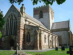 St Asaph Cathedral | |
|---|---|

| |
| Flag | |
| Gorau tarian, cyfiawnder (The best shield is justice) | |
| |
| [Interactive map] | |
| Area: | 260 square miles |
| Population: | 215,390 |
| County town: | Flint |
| County flower: | Bell heather [1] |
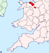
The County of Flint is a maritime shire of which the greater part lies along the estuary of the River Dee and on the coast of the Irish Sea, in the very north-eastern part of Wales.
Flintshire is broken into detached parts. The main body of the shire lies between the River Dee and the River Clwyd, reaching in from the coast up into the hills, but it also has an area detached from the main body known as Maelor Saesneg or English Maelor, which lies to the south-east as a wedge driven between Shropshire and Cheshire, separated from the main body of its county by a tract of Denbighshire. Between these two lies a small portion wholly surrounded by Denbighshire. Thus Flintshire has boundaries with Denbighshire in the west and south, Cheshire in the east and south-east and Shropshire in the south-east.
One of the smallest counties in the land, and the smallest of Wales, Flintshire is heavily developed. The coast along the Dee estuary is heavily developed by industry and the north coast is much developed for tourism.
Notwithstanding the county's small size, it contains an ancient cathedral, at St Asaph, the seat of a diocese founded in the sixth century.
Flintshire lies next to Cheshire and has been an Anglicised area since before the Norman conquest, with more place-names and families of English origin than elsewhere in Wales. Many of the villages of Flintshire are listed in the Domesday Book of 1086 under the heading of Cheshire.
Geography and industry
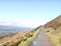
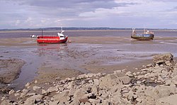
The Clwydian Mountains occupy much of the west of the county. The highest point is Moel Famau (1,820 feet). The main rivers are the Dee (the estuary of which forms much of the coast) and the Clwyd.
The main detached part of Flintshire is Maelor Saesneg in the south-east, between Denbighshire, Cheshire and Shropshire. Other detached parts are entirely surrounded by Denbighshire, namely the manors of Marford and Hoseley, Abenbury Fechan and Bryn Estyn, all on the outskirts of Wrexham, and also a small part of the parish of Erbistock around the Boat Inn. Also, a small part of Flintshire is physically if not technically detached, namely the small acres, including the village of Sealand, isolated across the River Dee when its course was changed to improve navigation.
The main industries of the county are manufacturing of aircraft components (Airbus), engines (Toyota), paper (Shotton Paper), steel processing (Corus), agriculture and tourism.
Industry
Parts of Flintshire have major manufacturing industries. Amongst these are a Toyota plant that manufactures engines, a Corus Group steelworks and Shotton Paper, but most importantly Airbus, making the wings for the Airbus A330 and A380 at Broughton.
There are daily flights of the Airbus Beluga transport aircraft of Airbus wings from Broughton for the smaller aircraft. The wings for the A380, which are too large to be transported by air use a multi-modal transport using Flintshire's roads, the River Dee and the port of Mostyn, also in Flintshire. The motto of Airbus in Flintshire is: "Without us, it's just a bus"; meaning that the parts that make Airbus aircraft fly, rather than just run along the ground, are made in Flintshire.
Flintshire is also known for its internet companies, some of which started here in the industrial lands and continue to support employment.
Formation
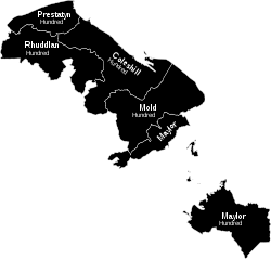
Flintshire was first formed in 1284 under the terms of the Statute of Rhuddlan to include cantrefs formerly parts of Gwynedd Is Conwy and Powys Fadog:
- Tegeingl
- Maelor Saesneg
Also included were the Lordships of Mold, Hawarden, Mostyn and Hope.
At the Laws in Wales Act, further provision was made. In 1535 Flintshire was not changed, as an existing shire. St Asaph ("Saint Tafse") was originally included amongst the "Lordships, Townships, Parishes, Commotes and Cantrefs of Denbighland" within Denbighshire[1] but adjustments were made later and it was confirmed to Flintshire in 1542.[2]
The Act also organised the county into five hundreds:
Towns and villages
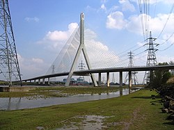
The chief towns of the county are on or by the Dee and the coast. The biggest, Buckley, Connah's Quay and Flint are industrial towns, though Flint has origins in the Middle Ages.
Cities
Towns
Civil communities
- Argoed
- Bagillt
- Bangor is-y-Coed*
- Bodelwyddan
- Bodfari
- Bronington*
- Broughton and Bretton
- Brynford
- Buckley
- Caerwys
- Cilcain
- Connah's Quay
- Cwm
- Dyserth
- Flint
- Gwernaffield
- Gwernymynydd
- Halkyn
- Hanmer*
- Hawarden
- Higher Kinnerton
- Holywell
- Hope
- Leeswood
- Llanasa
- Llanfynydd
- Maelor South*
- Mold
- Mostyn
- Nannerch
- Nercwys
- Northop Hall
- Northop
- Overton*
- Penyffordd
- Prestatyn
- Queensferry
- Rhuddlan
- Rhyl
- Saltney
- Sealand
- Shotton
- St Asaph
- Trelawnyd and Gwaenysgor
- Tremeirchion
- Treuddyn
- Waen
- Whitford
- Willington Worthenbury*
- Ysceifiog
*Located in Maelor Saesneg.
Things to see in Flintshire
| Key | |
| Cathedral/Abbey/Priory | |
| Accessible open space | |
| Amusement/Theme Park | |
| Castle | |
| Country Park | |
| Cadw | |
| Forestry Commission | |
| Heritage railway | |
| Historic House | |
| Museum (free/not free) | |
| National Trust | |
| Zoo | |

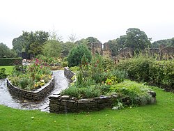
 Basingwerk Abbey, Holywell
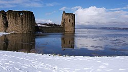
 Flint Castle
- Hawarden Castle:
 Maen Achwyfan Cross
 Rhuddlan Castle
 Ewloe Castle
- Connah's Quay industry
 St Winefride's Well, Holywell
 Wepre Country Park
Outside links
- Flintshire archaeological information
- Chester Recognizance Rolls calendar surname-indexed with scans
See also
References
| Counties of the United Kingdom |
|---|
|
Aberdeen • Anglesey • Angus • Antrim • Argyll • Armagh • Ayr • Banff • Bedford • Berks • Berwick • Brecknock • Buckingham • Bute • Caernarfon • Caithness • Cambridge • Cardigan • Carmarthen • Chester • Clackmannan • Cornwall • Cromarty • Cumberland • Denbigh • Derby • Devon • Dorset • Down • Dumfries • Dunbarton • Durham • East Lothian • Essex • Fermanagh • Fife • Flint • Glamorgan • Gloucester • Hants • Hereford • Hertford • Huntingdon • Inverness • Kent • Kincardine • Kinross • Kirkcudbright • Lanark • Lancaster • Leicester • Lincoln • Londonderry • Merioneth • Middlesex • Midlothian • Monmouth • Montgomery • Moray • Nairn • Norfolk • Northampton • Northumberland • Nottingham • Orkney • Oxford • Peebles • Pembroke • Perth • Radnor • Renfrew • Ross • Roxburgh • Rutland • Selkirk • Shetland • Salop • Somerset • Stafford • Stirling • Suffolk • Surrey • Sussex • Sutherland • Tyrone • Warwick • West Lothian • Westmorland • Wigtown • Wilts • Worcester • York |