West Lothian: Difference between revisions
mNo edit summary |
|||
| (5 intermediate revisions by 2 users not shown) | |||
| Line 6: | Line 6: | ||
|county town=[[Linlithgow]] | |county town=[[Linlithgow]] | ||
}} | }} | ||
The '''County of West Lothian''' or '''Linlithgow''' is a [[Counties of the United Kingdom|shire]] on the south bank and at the head of the [[Firth of Forth]]. Its county town is the royal burgh of [[Linlithgow]], | The '''County of West Lothian''' or '''Linlithgow''' is a [[Counties of the United Kingdom|shire]] on the south bank and at the head of the [[Firth of Forth]]. Its [[county town]] is the royal burgh of [[Linlithgow]], from which it takes its alternative name, Linlithgowshire. | ||
Just three counties bound West Lothian; [[Midlothian]] to the east, [[Lanarkshire]] to the south and Stirlingshire to the west. The [[River Forth]] and its estuary lie to the north, across which are [[Fife]] and the detached part of [[Perthshire]]. | Just three counties bound West Lothian; [[Midlothian]] to the east, [[Lanarkshire]] to the south and [[Stirlingshire]] to the west. The [[River Forth]] and its estuary lie to the north, across which are [[Fife]] and the detached part of [[Perthshire]]. | ||
West Lothian lies in the industrial and urban belt of the Central Lowlands, heavily affected by its being between the great cities of Edinburgh to the east and Glasgow to the west and by the major roads, railways and towns of the Clyde-Forth belt. | West Lothian lies in the industrial and urban belt of the Central Lowlands, heavily affected by its being between the great cities of [[Edinburgh]] to the east and [[Glasgow]] to the west and by the major roads, railways and towns of the Clyde-Forth belt. | ||
The county is a pinch-point between the Lowlands and the [[Highlands]]; the lower ground where Forth is fordable and in modern days bridgeable: the Forth Bridges cross to Fife at [[South Queensferry]]. | The county is a pinch-point between the Lowlands and the [[Highlands]]; the lower ground where Forth is fordable and in modern days bridgeable: the Forth Bridges cross to Fife at [[South Queensferry]]. | ||
| Line 17: | Line 17: | ||
West Lothian reaches from the upper reaches of the Firth of Forth inland. Furthest from the river it has its head in the hills, but much of the shire is the plain of the Forth and its tributaries. | West Lothian reaches from the upper reaches of the Firth of Forth inland. Furthest from the river it has its head in the hills, but much of the shire is the plain of the Forth and its tributaries. | ||
The county town, Linlithgow is a small town three miles inland, on Linlithgow Loch where there stand the remains of Linlithgow Palace, birthplace of Mary Queen of Scots. The main coastal town is [[Bo'ness]], once the port of [[Borrowstoun]] (whence its full name of Borrowstounness) but it has outgrown its parent to become an industrial town. The [[Antonine Wall]] ended here, at [[Kinneil]] by Bo'ness. | The county town, Linlithgow is a small town three miles inland, on Linlithgow Loch where there stand the remains of [[Linlithgow Palace]], birthplace of Mary Queen of Scots. The main coastal town is [[Bo'ness]], once the port of [[Borrowstoun]] (whence its full name of Borrowstounness) but it has outgrown its parent to become an industrial town. The [[Antonine Wall]] ended here, at [[Kinneil]] by Bo'ness. | ||
The main industrial towns such as [[Armadale]], [[Bathgate]] and [[Whitburn, West Lothian|Whitburn]], lie a little to the south, along the M8 and A71 corridor joining Edinburgh to Glasgow. An early on-shore oil industry was founded here; oil-shale mining, that has left as its legacy the "West Lothian Alps", ubiquitous spoil heaps. In this part of the Clyde-Forth Belt also is [[Livingston]], once a wee village but now a fully grown New Town. | The main industrial towns such as [[Armadale]], [[Bathgate]] and [[Whitburn, West Lothian|Whitburn]], lie a little to the south, along the [[M8 motorway|M8]] and A71 corridor joining Edinburgh to Glasgow. An early on-shore oil industry was founded here; oil-shale mining, that has left as its legacy the "West Lothian Alps", ubiquitous spoil heaps. In this part of the Clyde-Forth Belt also is [[Livingston]], once a wee village but now a fully grown New Town. | ||
==Geography== | ==Geography== | ||
| Line 27: | Line 27: | ||
Between Linlithgow and Bathgate there are several hills, the highest being [[The Knock]] (1,017 feet), and [[Cairnpapple Hill]], or Cairnnaple (1,000 feet), Cocklerue (912 feet), Riccarton Hills (832 feet) terminating eastwards in [[Binny Craig]], a striking eminence similar to those of Stirling and Edinburgh. In the coast district a few bold rocks are found, such as Dalmeny, Dundas (well wooded and with a precipitous front), the Binns and a rounded eminence of 559 feet named [[Glower-o'er-'em]] or Bonnytoun, bearing on its summit a monument to General Adrian Hope, who fell in the Indian Mutiny. | Between Linlithgow and Bathgate there are several hills, the highest being [[The Knock]] (1,017 feet), and [[Cairnpapple Hill]], or Cairnnaple (1,000 feet), Cocklerue (912 feet), Riccarton Hills (832 feet) terminating eastwards in [[Binny Craig]], a striking eminence similar to those of Stirling and Edinburgh. In the coast district a few bold rocks are found, such as Dalmeny, Dundas (well wooded and with a precipitous front), the Binns and a rounded eminence of 559 feet named [[Glower-o'er-'em]] or Bonnytoun, bearing on its summit a monument to General Adrian Hope, who fell in the Indian Mutiny. | ||
The border with Midlothian is formed by the [[River Almond]], which rises in Lanarkshire and flows north-eastwards to enter the Firth at [[Cramond]] after a course of 24 miles, most of which forms the county | The border with Midlothian is formed by the [[River Almond]], which rises in Lanarkshire and flows north-eastwards to enter the Firth at [[Cramond]] after a course of 24 miles, most of which forms the county border. Its right-hand tributary, Breich Water, constitutes another portion of the line dividing the same counties. The [[River Avon, West Lothian|River Avon]] rises in the detached portion of [[Dunbartonshire]] and flows eastwards across south [[Stirlingshire]] and then, following in the main a northerly direction, passes the county town on the west and reaches the Firth about midway between [[Grangemouth]] and [[Bo'ness]], having served as the border of Stirlingshire, during rather more than the latter half of its course. | ||
The only loch in West Lothian is Linlithgow Lake (a water of 102 acres), immediately adjoining the county town on the north, a favourite resort of curlers and skaters. It is 10 feet deep at the east end and 48 feet at the west. | The only loch in West Lothian is Linlithgow Lake (a water of 102 acres), immediately adjoining the county town on the north, a favourite resort of curlers and skaters. It is 10 feet deep at the east end and 48 feet at the west. | ||
===Geology=== | ===Geology=== | ||
The rocks of Linlithgowshire belong almost without exception to the Carboniferous system. At the base is the Calciferous Sandstone series, most of which lies between the Bathgate Hills and the eastern | The rocks of Linlithgowshire belong almost without exception to the Carboniferous system. At the base is the Calciferous Sandstone series, most of which lies between the Bathgate Hills and the eastern border of the county. In this series are the Queensferry limestone, the equivalent of the Burdiehouse limestone of Edinburgh, and the Binny sandstone group with shales and clays and the Houston coal bed. | ||
At more than one horizon in this series oil shales are found. The Bathgate Hills are formed of basaltic lavas and tuffs an interbedded volcanic group possibly | At more than one horizon in this series oil shales are found. The Bathgate Hills are formed of basaltic lavas and tuffs an interbedded volcanic group possibly 2,000 ft thick in the Calciferous Sandstone and Carboniferous Limestone series. A peculiar serpentinous variety of the prevailing rock is quarried at Blackburn for oven floors; it is known as "lakestone". Binns Hill is the site of one of the volcanic cones of the period. | ||
quarried at Blackburn for oven floors; it is known as "lakestone". Binns Hill is the site of one of the volcanic cones of the period. | |||
The Carboniferous Limestone series consists of an upper and lower limestone group including the Petershill, Index, Dykeneuk and Craigenbuck limestones and a middle group of shales, ironstones and coals; the Smithy, Easter Main, Foul, Red and Splint coals belong to this horizon. Above the Carboniferous Limestone the millstone grit series crops in a belt which may be traced from the mouth of the Avon southwards to Whitburn. This is followed by the true coal-measures with the Boghead or Torbanehill coal, the Colinburn, Main, Ball, Mill and Upper Cannel or Shotts gas coals of Armadale, Torbanehill and Fauldhouse. | The Carboniferous Limestone series consists of an upper and lower limestone group including the Petershill, Index, Dykeneuk and Craigenbuck limestones and a middle group of shales, ironstones and coals; the Smithy, Easter Main, Foul, Red and Splint coals belong to this horizon. Above the Carboniferous Limestone the millstone grit series crops in a belt which may be traced from the mouth of the Avon southwards to Whitburn. This is followed by the true coal-measures with the Boghead or Torbanehill coal, the Colinburn, Main, Ball, Mill and Upper Cannel or Shotts gas coals of Armadale, Torbanehill and Fauldhouse. | ||
| Line 49: | Line 48: | ||
[[File:Linlithgow Palace - geograph.org.uk - 1416190.jpg|right|thumb|200px|Linlithgow Palace]] | [[File:Linlithgow Palace - geograph.org.uk - 1416190.jpg|right|thumb|200px|Linlithgow Palace]] | ||
From the later Middle Ages the historical associations of the county mainly cluster round the county town, Linlithgow. Here in 1424, King James I built Linlithgow Palace it remained a royal palace popular with the ensuing Stewart Kings. On 4 September 1526, after James IV had been slain at Flodden, a civil war of the nobles was fought close by, the Battle of Linlithgow Bridge between an army of the Earl of Lennox and one of James Hamilton, 1st Earl of Arran, each seeking to control the child King James V. James V was born in the palace, as was Mary Queen of Scots. The Palace was abandoned at the Union of the Crowns, the King removing himself to London, and in 1746 it was used as a lodging by the army marching to pacify the Highlands, and was heavily damaged. | From the later Middle Ages the historical associations of the county mainly cluster round the county town, Linlithgow. Here in 1424, King James I built Linlithgow Palace it remained a royal palace popular with the ensuing Stewart Kings. On 4 September 1526, after James IV had been slain at Flodden, a civil war of the nobles was fought close by, the Battle of Linlithgow Bridge between an army of the Earl of Lennox and one of James Hamilton, 1st Earl of Arran, each seeking to control the child King James V. James V was born in the palace, as was Mary Queen of Scots. The Palace was abandoned at the Union of the Crowns, the King removing himself to [[London]], and in 1746 it was used as a lodging by the army marching to pacify the Highlands, and was heavily damaged. | ||
[[File:ESForth Rail Bridge seen from Queensferry shore.jpg|right|thumb|200px|The Forth Bridge]] | [[File:ESForth Rail Bridge seen from Queensferry shore.jpg|right|thumb|200px|The Forth Bridge]] | ||
The Industrial Revolution and the coming of the railway broke upon West Lothian in force. Oil shale was mined, and coal along the | The Industrial Revolution and the coming of the railway broke upon West Lothian in force. Oil shale was mined, and coal along the border with Midlothian on the Esk. The famous Forth Bridge was thrown across the Forth between 1883 and 1890, bearing the railway to [[Fife]]. The roads and railways between Edinburgh and Glasgow sliced through the shire and its towns grew. The Forth Road Bridge was built close by the railway bridge in 1964, which finally ended Queen Margaret's ferry. | ||
The problem of overpopulation was addressed with New Towns, of which one was at [[Livingston]], designated in 1962 and built swiftly thereafter on what had been farmland and wee villages. | The problem of overpopulation was addressed with New Towns, of which one was at [[Livingston]], designated in 1962 and built swiftly thereafter on what had been farmland and wee villages. | ||
| Line 72: | Line 71: | ||
*[[Livingston]] | *[[Livingston]] | ||
*[[South Queensferry]] | *[[South Queensferry]] | ||
*[[Whitburn]] | *[[Whitburn, West Lothian|Whitburn]] | ||
===Villages=== | ===Villages=== | ||
{{div col|2}} | |||
*[[Abercorn]] | *[[Abercorn]] | ||
*[[Blackridge, West Lothian|Blackridge]] | *[[Blackridge, West Lothian|Blackridge]] | ||
| Line 96: | Line 96: | ||
*[[Westfield, West Lothian|Westfield]] | *[[Westfield, West Lothian|Westfield]] | ||
*[[Winchburgh]] | *[[Winchburgh]] | ||
{{div col end}} | |||
===Parishes=== | ===Parishes=== | ||
| Line 104: | Line 105: | ||
*[[Dalmeny]] | *[[Dalmeny]] | ||
*[[Ecclesmachan]] | *[[Ecclesmachan]] | ||
*[[Kirkliston]] | *[[Kirkliston]]<sup>†</sup> | ||
*[[Linlithgow]] | *[[Linlithgow]] | ||
*[[Livingston]] | *[[Livingston]] | ||
*[[Torphichen]] | *[[Torphichen]] | ||
*[[Uphall]] | *[[Uphall]] | ||
*[[Whitburn]] | *[[Whitburn, West Lothian|Whitburn]] | ||
{{parishlistend}} | {{parishlistend}} | ||
†: Extends into Midlothian | |||
==Places of interest== | ==Places of interest== | ||
| Line 119: | Line 120: | ||
*{{i-Castle}} [[Blackness Castle]] | *{{i-Castle}} [[Blackness Castle]] | ||
*[[Cairnpapple Hill]] | *[[Cairnpapple Hill]] | ||
*Forth Bridge | *[[Forth Bridge]] | ||
*[[Linlithgow Palace]] | *[[Linlithgow Palace]] | ||
*Polkemmet Country Park | *Polkemmet Country Park | ||
Latest revision as of 14:00, 30 May 2017
| West Lothian United Kingdom | |
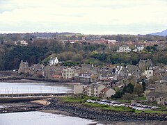 South Queensferry | |
|---|---|
| Aye for the Common Weal | |
| |
| [Interactive map] | |
| Area: | 120 square miles |
| Population: | 154,830 |
| County town: | Linlithgow |
| County flower: | Common spotted-orchid [1] |
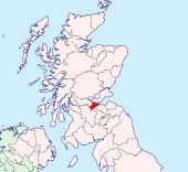
The County of West Lothian or Linlithgow is a shire on the south bank and at the head of the Firth of Forth. Its county town is the royal burgh of Linlithgow, from which it takes its alternative name, Linlithgowshire.
Just three counties bound West Lothian; Midlothian to the east, Lanarkshire to the south and Stirlingshire to the west. The River Forth and its estuary lie to the north, across which are Fife and the detached part of Perthshire.
West Lothian lies in the industrial and urban belt of the Central Lowlands, heavily affected by its being between the great cities of Edinburgh to the east and Glasgow to the west and by the major roads, railways and towns of the Clyde-Forth belt.
The county is a pinch-point between the Lowlands and the Highlands; the lower ground where Forth is fordable and in modern days bridgeable: the Forth Bridges cross to Fife at South Queensferry.
The county generally
West Lothian reaches from the upper reaches of the Firth of Forth inland. Furthest from the river it has its head in the hills, but much of the shire is the plain of the Forth and its tributaries.
The county town, Linlithgow is a small town three miles inland, on Linlithgow Loch where there stand the remains of Linlithgow Palace, birthplace of Mary Queen of Scots. The main coastal town is Bo'ness, once the port of Borrowstoun (whence its full name of Borrowstounness) but it has outgrown its parent to become an industrial town. The Antonine Wall ended here, at Kinneil by Bo'ness.
The main industrial towns such as Armadale, Bathgate and Whitburn, lie a little to the south, along the M8 and A71 corridor joining Edinburgh to Glasgow. An early on-shore oil industry was founded here; oil-shale mining, that has left as its legacy the "West Lothian Alps", ubiquitous spoil heaps. In this part of the Clyde-Forth Belt also is Livingston, once a wee village but now a fully grown New Town.
Geography
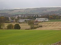
West Lothian is a small county, though populous, of 120 square miles and a coast line of 17 miles. It is fairly low-lying, much of the land being in the plains of the River Forth and its firth. The surface rises very gradually from the Firth to the hilly district in the south.
Between Linlithgow and Bathgate there are several hills, the highest being The Knock (1,017 feet), and Cairnpapple Hill, or Cairnnaple (1,000 feet), Cocklerue (912 feet), Riccarton Hills (832 feet) terminating eastwards in Binny Craig, a striking eminence similar to those of Stirling and Edinburgh. In the coast district a few bold rocks are found, such as Dalmeny, Dundas (well wooded and with a precipitous front), the Binns and a rounded eminence of 559 feet named Glower-o'er-'em or Bonnytoun, bearing on its summit a monument to General Adrian Hope, who fell in the Indian Mutiny.
The border with Midlothian is formed by the River Almond, which rises in Lanarkshire and flows north-eastwards to enter the Firth at Cramond after a course of 24 miles, most of which forms the county border. Its right-hand tributary, Breich Water, constitutes another portion of the line dividing the same counties. The River Avon rises in the detached portion of Dunbartonshire and flows eastwards across south Stirlingshire and then, following in the main a northerly direction, passes the county town on the west and reaches the Firth about midway between Grangemouth and Bo'ness, having served as the border of Stirlingshire, during rather more than the latter half of its course.
The only loch in West Lothian is Linlithgow Lake (a water of 102 acres), immediately adjoining the county town on the north, a favourite resort of curlers and skaters. It is 10 feet deep at the east end and 48 feet at the west.
Geology
The rocks of Linlithgowshire belong almost without exception to the Carboniferous system. At the base is the Calciferous Sandstone series, most of which lies between the Bathgate Hills and the eastern border of the county. In this series are the Queensferry limestone, the equivalent of the Burdiehouse limestone of Edinburgh, and the Binny sandstone group with shales and clays and the Houston coal bed.
At more than one horizon in this series oil shales are found. The Bathgate Hills are formed of basaltic lavas and tuffs an interbedded volcanic group possibly 2,000 ft thick in the Calciferous Sandstone and Carboniferous Limestone series. A peculiar serpentinous variety of the prevailing rock is quarried at Blackburn for oven floors; it is known as "lakestone". Binns Hill is the site of one of the volcanic cones of the period.
The Carboniferous Limestone series consists of an upper and lower limestone group including the Petershill, Index, Dykeneuk and Craigenbuck limestones and a middle group of shales, ironstones and coals; the Smithy, Easter Main, Foul, Red and Splint coals belong to this horizon. Above the Carboniferous Limestone the millstone grit series crops in a belt which may be traced from the mouth of the Avon southwards to Whitburn. This is followed by the true coal-measures with the Boghead or Torbanehill coal, the Colinburn, Main, Ball, Mill and Upper Cannel or Shotts gas coals of Armadale, Torbanehill and Fauldhouse.
History
The remains of the earliest inhabitants are found here and there. Stone cists have been discovered at Carlowrie, Dalmeny, Newliston and elsewhere; on Cairnnaple is a circular structure of remote but unknown date; and at Kipps is a cromlech that was once surrounded by stones.
The Romans set West Lothian within their empire. The Emperor Antoninus considered Hadrian's Wall to be too far south and instead built a border wall at the narrow neck of the land identified by Agricola, as Tacitus reports, between the River Forth and the River Clyde. Here was built the Antonine Wall, of which the easternmost miles run through West Lothian to the Forth. A fine legionary tablet was discovered at Bridgeness in 1868 which was hailed as conclusive evidence that the wall ended as Bede reported, and not at Carriden as had been supposed. Roman camps have been located at several spots. The successors of Antoninus abandoned his wall and the client tribes it protected and retreated to the Solway Firth.
After the Romans abandoned Britannia entirely, East Lothian was left to the Gododdin, whom the Romans had known as the Votadini, but in time their lands were conquered by the Bernician English. On the Hill of Bowden is an earthwork, which J Stuart Glennie and others connect with the struggle of the ancient Britons against the incoming English tribes but it was a vain struggle; thus these lands became part of the great Kingdom of the Northumbrians. The first use of the name Engla land (England) is in a translation of Bede's Ecclesiastical History of the English People, referring to the place of Abercorn in West Lothian.[1] Bede or his source appears to have been very familiar with these lands. The frontier between the nations must have been close by though, for when Bede describes the Antonine Wall he gives the name of the village at its eastern end in two languages, called Penneltun but known in Pictish as Peanfahel,[2] while Nennius in the early ninth century gives it names in three languages; Penguaul in Welsh, Cenail in Gaelic and Peneltun in English.[3] The great majority of place-names in West Lothian today are from Old English or its descendant, Scots, but with a mixture of Old Welsh, Pictish and Gaelic.
In the eleventh century Queen Margaret (St Margaret of Scotland) established a ferry for pilgrims at the place where the Firth of Forth narrows, whence South Queensferry in West Lothian, facing North Queensferry in Fife, and ferry services continued until 1964.
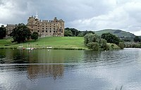
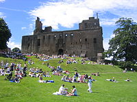
From the later Middle Ages the historical associations of the county mainly cluster round the county town, Linlithgow. Here in 1424, King James I built Linlithgow Palace it remained a royal palace popular with the ensuing Stewart Kings. On 4 September 1526, after James IV had been slain at Flodden, a civil war of the nobles was fought close by, the Battle of Linlithgow Bridge between an army of the Earl of Lennox and one of James Hamilton, 1st Earl of Arran, each seeking to control the child King James V. James V was born in the palace, as was Mary Queen of Scots. The Palace was abandoned at the Union of the Crowns, the King removing himself to London, and in 1746 it was used as a lodging by the army marching to pacify the Highlands, and was heavily damaged.
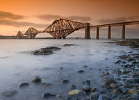
The Industrial Revolution and the coming of the railway broke upon West Lothian in force. Oil shale was mined, and coal along the border with Midlothian on the Esk. The famous Forth Bridge was thrown across the Forth between 1883 and 1890, bearing the railway to Fife. The roads and railways between Edinburgh and Glasgow sliced through the shire and its towns grew. The Forth Road Bridge was built close by the railway bridge in 1964, which finally ended Queen Margaret's ferry.
The problem of overpopulation was addressed with New Towns, of which one was at Livingston, designated in 1962 and built swiftly thereafter on what had been farmland and wee villages.
The West Lothian question
The "West Lothian question" is cited by politicians to much general puzzlement. It refers to a question asked in 1977 by Tam Dalyell, Member of Parliament for West Lothian. It is in essence "Were a devolved Scottish legislature erected, how could one deal with the problem that MPs for Scottish constituencies could still vote at Westminster in matters concerning England and Wales when such matters are devolved in Scotland?" This question was raised in his book Devolution: The End of Britain?, but named "The West Lothian Question" later that year by the late Enoch Powell.[4]
Towns and viilages of West Lothian
Towns
Villages
Parishes
†: Extends into Midlothian
Places of interest
| Key | |
| Cathedral/Abbey/Priory | |
| Accessible open space | |
| Amusement/Theme Park | |
| Castle | |
| Country Park | |
| Historic Scotland | |
| Forestry Commission | |
| Heritage railway | |
| Historic House | |
| Museum (free/not free) | |
| National Trust for Scotland | |
| Zoo | |
 Beecraigs Country Park
 Blackness Castle
- Cairnpapple Hill
- Forth Bridge
- Linlithgow Palace
- Polkemmet Country Park
 Torphichen Preceptory
Outside links
References
- ↑ Ecclesiastical History of the English People, by Bede
- ↑ Incipit autem duorum ferme milium spatio a monasterio Aebbercurnig ad occidentem in loco, qui sermone Pictorum Peanfahel, lingua autem Anglorum Penneltun appellatur - "Historia Ecclesiasticam Gentis Anglorum" (Bede)
- ↑ "Historia Brittonum" (Nennius)
- ↑ "Referendum (English Parliament) Bill (Hansard, 16 January 1998)". Hansard.millbanksystems.com. http://hansard.millbanksystems.com/commons/1998/jan/16/referendum-english-parliament-bill#S6CV0304P0_19980116_HOC_77. Retrieved 2010-09-20.
Books
- Sibbald, Sir R: History of the Sheriffdoms of Linlithgow and Stirlingshire (Edinburgh, 1710)
- Waldie, G: Walks along the Northern Roman Wall (Linlithgow, 1883)
- Cunningham, R J H: Geology of the Lothians (Edinburgh, 1838)
| Counties of the United Kingdom |
|---|
|
Aberdeen • Anglesey • Angus • Antrim • Argyll • Armagh • Ayr • Banff • Bedford • Berks • Berwick • Brecknock • Buckingham • Bute • Caernarfon • Caithness • Cambridge • Cardigan • Carmarthen • Chester • Clackmannan • Cornwall • Cromarty • Cumberland • Denbigh • Derby • Devon • Dorset • Down • Dumfries • Dunbarton • Durham • East Lothian • Essex • Fermanagh • Fife • Flint • Glamorgan • Gloucester • Hants • Hereford • Hertford • Huntingdon • Inverness • Kent • Kincardine • Kinross • Kirkcudbright • Lanark • Lancaster • Leicester • Lincoln • Londonderry • Merioneth • Middlesex • Midlothian • Monmouth • Montgomery • Moray • Nairn • Norfolk • Northampton • Northumberland • Nottingham • Orkney • Oxford • Peebles • Pembroke • Perth • Radnor • Renfrew • Ross • Roxburgh • Rutland • Selkirk • Shetland • Salop • Somerset • Stafford • Stirling • Suffolk • Surrey • Sussex • Sutherland • Tyrone • Warwick • West Lothian • Westmorland • Wigtown • Wilts • Worcester • York |