Kinross-shire: Difference between revisions
No edit summary |
|||
| (8 intermediate revisions by 2 users not shown) | |||
| Line 1: | Line 1: | ||
{{Infobox county | {{Infobox county | ||
|name=Kinross-shire | |name=Kinross-shire | ||
|map image=Kinross- | |map image=Kinross-shire Brit Isles Sect 2.svg | ||
|picture=LochLevenFromKinross.jpg | |picture=LochLevenFromKinross.jpg | ||
|picture caption=Loch Leven from Kinross | |picture caption=Loch Leven from Kinross | ||
| Line 10: | Line 10: | ||
==History== | ==History== | ||
The Shire of Kinross was formed in the thirteenth century when the two parishes of [[Kinross]] and [[Orwell, Kinross-shire]] were removed from the [[Fothriff]] area of Fife. Cleish, [[Portmoak]] and Tullibole were added by Act of Parliament in 1685.<ref>[http://www.1911encyclopedia.org/Kinross-Shire ''Kinross-shire'', from the 1911 Encyclopædia Britannica (Love to Know)]</ref><ref>[http://www.tulbol.demon.co.uk/annals2.htm Text of the 1685 Act from ''The Annals of Kinross-shire'' by Dr. Ebenezer Henderson (Fossoway and District Community Council]</ref> | The Shire of Kinross was formed in the thirteenth century when the two parishes of [[Kinross]] and [[Orwell, Kinross-shire|Orwell]] were removed from the [[Fothriff]] area of Fife. Cleish, [[Portmoak]] and Tullibole were added by Act of Parliament in 1685.<ref>[http://www.1911encyclopedia.org/Kinross-Shire ''Kinross-shire'', from the 1911 Encyclopædia Britannica (Love to Know)]</ref><ref>[http://www.tulbol.demon.co.uk/annals2.htm Text of the 1685 Act from ''The Annals of Kinross-shire'' by Dr. Ebenezer Henderson (Fossoway and District Community Council]</ref> | ||
The county suffered a decline in population in the 19th century as its inhabitants migrated to the urban areas to find work in manufacturing etc. The population of Kinross-shire in 1891 was 6,673, in 1901 it was 6,981. The only towns are Kinross and [[Milnathort]]. The 1971 census recorded a population of 6,423 in the county. The decline was hastened by the closure of the railways in the county soon after the Second World War. However, in recent years, construction of the M90 motorway north of the Forth Road Bridge has resulted in the area becoming more prominent. Tourism has increased, with visitors attracted by the unspoiled country villages and gently rolling hills reaching the shores of [[Loch Leven, Kinross-shire|Loch Leven]]. The villages of [[Kinnesswood]] and [[Scotlandwell]] are attractive, and there are ancient standing stones at Orwell. The 'T in the Park' music festival | The county suffered a decline in population in the 19th century as its inhabitants migrated to the urban areas to find work in manufacturing etc. The population of Kinross-shire in 1891 was 6,673, in 1901 it was 6,981. The only towns are Kinross and [[Milnathort]]. The 1971 census recorded a population of 6,423 in the county. The decline was hastened by the closure of the railways in the county soon after the Second World War. However, in recent years, construction of the [[M90 motorway]] north of the [[Forth Road Bridge]] has resulted in the area becoming more prominent. Tourism has increased, with visitors attracted by the unspoiled country villages and gently rolling hills reaching the shores of [[Loch Leven, Kinross-shire|Loch Leven]]. The population according to the 2011 census was nearly double that of 1971, although it is still the second least populous county in Britain, with only [[Cromartyshire]] having fewer residents. | ||
The villages of [[Kinnesswood]] and [[Scotlandwell]] are attractive, and there are ancient standing stones at Orwell. The 'T in the Park' music festival was held in Balado from 1993, becoming a major annual event until 2014. The population is now double what it was in the 1970s. | |||
==Geography== | ==Geography== | ||
The county is dominated by [[Loch Leven, Kinross-shire|Loch Leven]], a large inland loch with two islands and home to an internationally-important nature reserve. One of the islands contains the castle where Mary, Queen of Scots was once held prisoner. Much of the land in Kinross–shire is fertile agricultural land and most of the inhabitants were originally employed on the land. | Kinross-shire is bordered by [[Perthshire]] to the north and [[Fife]] to the south. A small detached part lies to the south-east of the main body, to the west of [[Leslie]]. The county is dominated by [[Loch Leven, Kinross-shire|Loch Leven]], a large inland loch with two islands and home to an internationally-important nature reserve. One of the islands contains the castle where Mary, Queen of Scots was once held prisoner. Much of the land in Kinross–shire is fertile agricultural land and most of the inhabitants were originally employed on the land. | ||
The gently-rolling farmland surrounding Loch Leven gives way to steep, more rugged terrain. | The gently-rolling farmland surrounding Loch Leven gives way to steep, more rugged terrain. | ||
| Line 21: | Line 23: | ||
{| | {| | ||
|width="30%"| | |width="30%"| | ||
*[[Carnbo]] | *[[Carnbo]] | ||
*[[Cleish]] | *[[Cleish]] | ||
| Line 29: | Line 30: | ||
*[[Easter Balgedie]] | *[[Easter Balgedie]] | ||
*[[Gairney Bank]] | *[[Gairney Bank]] | ||
|width="30%"| | |width="30%" valign="top"| | ||
*[[Glenlomond]] | *[[Glenlomond]] | ||
*[[Keltybridge]] | *[[Keltybridge]] | ||
*[[Kinnesswood]] | *[[Kinnesswood]] | ||
*[[Kinross]] | *[[Kinross]] (''[[county town]]'') | ||
*[[Milnathort]] | *[[Milnathort]] | ||
*[[Scotlandwell]] | *[[Scotlandwell]] | ||
*[[Wester Balgedie]] | *[[Wester Balgedie]] | ||
|} | |} | ||
==Parishes== | |||
===Parishes=== | |||
{{parishliststart}} | {{parishliststart}} | ||
*[[Cleish]] | *[[Cleish]] | ||
*[[Fossoway]] | *[[Fossoway]]* | ||
*[[Kinross]] | *[[Kinross]] | ||
*[[Orwell, Kinross-shire|Orwell]] | *[[Orwell, Kinross-shire|Orwell]] | ||
*[[Portmoak]] | *[[Portmoak]] | ||
{{parishlistend}} | {{parishlistend}} | ||
<nowiki>*</nowiki>: Shared with Perthshire.<br />Additionally the parishes of [[Forteviot]] and [[Arngask]] extend into Kinross-shire | |||
==References== | ==References== | ||
{{reflist}} | {{reflist}} | ||
{{British county}} | {{British county}} | ||
Latest revision as of 17:30, 5 April 2017
| Kinross-shire United Kingdom | |
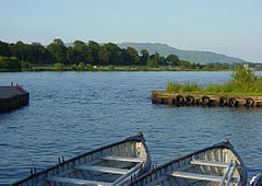
 Loch Leven from Kinross | |
|---|---|
| For all Time | |

| |
| [Interactive map] | |
| Area: | 73 square miles |
| Population: | 11,223 |
| County town: | Kinross |
| County flower: | Holy-grass [1] |
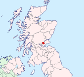
The County of Kinross is a shire lying between Perthshire and Fife, on Loch Leven. Kinross-shire is the second-smallest county in Britain; after its neighbour, Clackmannanshire. It is promoted by the Kinross-shire Partnership, a body bringing together local government, tourist organisations and local organisations.[1][2]
History
The Shire of Kinross was formed in the thirteenth century when the two parishes of Kinross and Orwell were removed from the Fothriff area of Fife. Cleish, Portmoak and Tullibole were added by Act of Parliament in 1685.[3][4]
The county suffered a decline in population in the 19th century as its inhabitants migrated to the urban areas to find work in manufacturing etc. The population of Kinross-shire in 1891 was 6,673, in 1901 it was 6,981. The only towns are Kinross and Milnathort. The 1971 census recorded a population of 6,423 in the county. The decline was hastened by the closure of the railways in the county soon after the Second World War. However, in recent years, construction of the M90 motorway north of the Forth Road Bridge has resulted in the area becoming more prominent. Tourism has increased, with visitors attracted by the unspoiled country villages and gently rolling hills reaching the shores of Loch Leven. The population according to the 2011 census was nearly double that of 1971, although it is still the second least populous county in Britain, with only Cromartyshire having fewer residents.
The villages of Kinnesswood and Scotlandwell are attractive, and there are ancient standing stones at Orwell. The 'T in the Park' music festival was held in Balado from 1993, becoming a major annual event until 2014. The population is now double what it was in the 1970s.
Geography
Kinross-shire is bordered by Perthshire to the north and Fife to the south. A small detached part lies to the south-east of the main body, to the west of Leslie. The county is dominated by Loch Leven, a large inland loch with two islands and home to an internationally-important nature reserve. One of the islands contains the castle where Mary, Queen of Scots was once held prisoner. Much of the land in Kinross–shire is fertile agricultural land and most of the inhabitants were originally employed on the land. The gently-rolling farmland surrounding Loch Leven gives way to steep, more rugged terrain.
Towns and villages
Parishes
*: Shared with Perthshire.
Additionally the parishes of Forteviot and Arngask extend into Kinross-shire
References
- ↑ http://www.kinross.cc/partnership/home.htm
- ↑ http://www.pkc.gov.uk/NR/rdonlyres/DA8FF87D-D891-4EFD-8822-ED80961EA94B/0/06292.pdf
- ↑ Kinross-shire, from the 1911 Encyclopædia Britannica (Love to Know)
- ↑ Text of the 1685 Act from The Annals of Kinross-shire by Dr. Ebenezer Henderson (Fossoway and District Community Council
| Counties of the United Kingdom |
|---|
|
Aberdeen • Anglesey • Angus • Antrim • Argyll • Armagh • Ayr • Banff • Bedford • Berks • Berwick • Brecknock • Buckingham • Bute • Caernarfon • Caithness • Cambridge • Cardigan • Carmarthen • Chester • Clackmannan • Cornwall • Cromarty • Cumberland • Denbigh • Derby • Devon • Dorset • Down • Dumfries • Dunbarton • Durham • East Lothian • Essex • Fermanagh • Fife • Flint • Glamorgan • Gloucester • Hants • Hereford • Hertford • Huntingdon • Inverness • Kent • Kincardine • Kinross • Kirkcudbright • Lanark • Lancaster • Leicester • Lincoln • Londonderry • Merioneth • Middlesex • Midlothian • Monmouth • Montgomery • Moray • Nairn • Norfolk • Northampton • Northumberland • Nottingham • Orkney • Oxford • Peebles • Pembroke • Perth • Radnor • Renfrew • Ross • Roxburgh • Rutland • Selkirk • Shetland • Salop • Somerset • Stafford • Stirling • Suffolk • Surrey • Sussex • Sutherland • Tyrone • Warwick • West Lothian • Westmorland • Wigtown • Wilts • Worcester • York |