Yorkshire
| Yorkshire United Kingdom | |

| |
|---|---|
| Flag | |

| |
| [Interactive map] | |
| Area: | 6,081 square miles |
| Population: | 5,218,838 |
| County town: | York |
| Biggest town: | Leeds |
| County flower: | Harebell [1] |
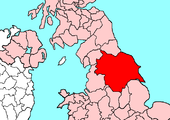
The County of York is by far the largest shire in the United Kingdom as well as the most populous. The northern boundary of Yorkshire is the River Tees, the eastern boundary is marked by the North Sea coast and the southern boundary the Humber Estuary and River Don and River Sheaf. The western boundary meanders along the western slopes of the Pennine Hills to again meet the River Tees. It is bordered by the counties of Durham, Lincoln, Nottingham, Derby, Chester, Lancaster and Westmorland.
Yorkshire is divided into three Ridings, whose boundaries meet at the walls of the City of York:
- the East Riding
- the North Riding
- the West Riding
The City of York within the walls is thus the only part of Yorkshire not within one of the three Ridings.
Within the borders of the county are areas which are widely considered to be among the greenest in England, due to the vast stretches of unspoiled countryside in the Yorkshire Dales and North York Moors and to the open aspect of some of the major cities.[1][2] Yorkshire has sometimes been nicknamed "God's Own County".[3] The emblem of Yorkshire is the white rose of the royal House of York, which as displayed on a dark blue background forms the Flag of Yorkshire.[4] Yorkshire Day, held on 1 August, is a celebration of the general culture of Yorkshire, ranging from its history to its own dialect.[5]
Geography
Physical and geological

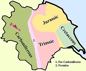
In Yorkshire there is a very close relationship between the major topographical areas and the geological period in which they were formed. The Pennine chain of hills in the west is of Carboniferous origin. The central vale isPermo-Triassic. The North York Moors in the north-east of the county are Jurassic in age while the Yorkshire Wolds to the south east are Cretaceous chalk uplands.
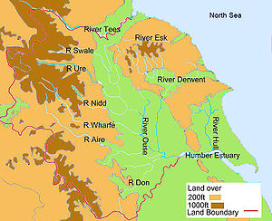
Yorkshire is drained by several rivers. In western and central Yorkshire the many rivers empty their waters into the River Ouse which reaches the North Sea via the Humber Estuary.[6] The most northerly of the rivers in the Ouse system is the River Swale, which drains Swaledale before passing through Richmond and meandering across the Vale of Mowbray. Next, draining Wensleydale, is the River Ure, which joins the Swale east of Boroughbridge. The River Nidd rises on the edge of the Yorkshire Dales National Park and flows along Nidderdale before reaching the Vale of York.[6]

The Ouse is the name given to the river after its confluence with the Ure at Ouse Gill Beck. The River Wharfe, which drains Wharfedale, joins the Ouse upstream of Cawood.[6] The Rivers Aire and Calder are more southerly contributors to the River Ouse and the most southerly Yorkshire tributary is the River Don, which flows northwards to join the main river at Goole. In the far north of the county the River Tees flows eastwards through Teesdale and empties its waters into the North Sea downstream of Middlesbrough. The smaller River Esk flows from west to east at the northern foot of the North York Moors to reach the sea at Whitby.[6] The River Derwent rises on the North York Moors, flows south then westwards through the Vale of Pickering then turns south again to drain the eastern part of the Vale of York. It empties into the River Ouse at Barmby on the Marsh.[6] To the east of the Yorkshire Wolds the River Hull flows southwards to join the Humber Estuary at Kingston upon Hull. The western Pennines are served by the River Ribble which drains westwards into the Irish Sea close to Lytham St Annes in Lancashire.[6]
References
- ↑ Benjamin, Alison; Wainwright, Martin (20 October 2007). "And the winner of the award for the greenest city in Britain is ... Bradford". London: Guardian Unlimited. http://www.guardian.co.uk/environment/2007/oct/20/communities?gusrc=rss&feed=networkfront. Retrieved 24 October 2007.
- ↑ "Green space conference comes to UK's 'greenest city'". Yorkshire Forward. 23 March 2006. Archived from the original on 18 November 2006. http://web.archive.org/web/20061118034333/http://www.yorkshire-forward.com/www/view.asp?content_id=2934&parent_id=263. Retrieved 24 October 2007.
- ↑ "God's own county". London: Guardian Unlimited. 2 June 2006. http://www.guardian.co.uk/travel/2006/jun/02/travelnews.shortbreaks.unitedkingdom. Retrieved 24 October 2007.
- ↑ "Yorkshire (United Kingdom)". CRWFlags.nom. http://www.crwflags.com/fotw/flags/gb-en-ys.html. Retrieved 25 October 2007.
- ↑ "Yorkshire Day". Army.mod.uk. 18 February 2008. http://www2.army.mod.uk/yorkshire_regiment/regiment/history/battle_honours/yorkshire_day.htm. Retrieved 3 October 2008.
- ↑ 6.0 6.1 6.2 6.3 6.4 6.5 British Canoe Union, Yorkshire and Humberside Region, Access and Recreation Committees ; prepared by Mike Twiggs and David Taylor. (1992). Yorkshire Rivers: A Canoeists Guide. Menasha Ridge Press. ISBN 978-1-871890-16-7.
Outside links
This county article is a stub: help to improve Wikishire by building it up.
| Counties of the United Kingdom |
|---|
|
Aberdeen • Anglesey • Angus • Antrim • Argyll • Armagh • Ayr • Banff • Bedford • Berks • Berwick • Brecknock • Buckingham • Bute • Caernarfon • Caithness • Cambridge • Cardigan • Carmarthen • Chester • Clackmannan • Cornwall • Cromarty • Cumberland • Denbigh • Derby • Devon • Dorset • Down • Dumfries • Dunbarton • Durham • East Lothian • Essex • Fermanagh • Fife • Flint • Glamorgan • Gloucester • Hants • Hereford • Hertford • Huntingdon • Inverness • Kent • Kincardine • Kinross • Kirkcudbright • Lanark • Lancaster • Leicester • Lincoln • Londonderry • Merioneth • Middlesex • Midlothian • Monmouth • Montgomery • Moray • Nairn • Norfolk • Northampton • Northumberland • Nottingham • Orkney • Oxford • Peebles • Pembroke • Perth • Radnor • Renfrew • Ross • Roxburgh • Rutland • Selkirk • Shetland • Salop • Somerset • Stafford • Stirling • Suffolk • Surrey • Sussex • Sutherland • Tyrone • Warwick • West Lothian • Westmorland • Wigtown • Wilts • Worcester • York |