Ayrshire: Difference between revisions
No edit summary |
No edit summary |
||
| Line 15: | Line 15: | ||
*Kyle | *Kyle | ||
*Carrick | *Carrick | ||
Ayrshire is one of the most agriculturally fertile regions of Scotland. Potatoes are grown in fields near the coast, using seaweed-based fertiliser, and in addition the county produces pork products, other root vegetables, cattle and summer berries such as strawberries are grown abundantly. | |||
Ayrshire shares with [[Wigtownshire]] and [[Kirkcudbrightshire]] to the south some wonderful rugged hill country known as the [[Galloway Hills]]. These hill lie to the west of the A713 (Ayr to [[Castle Douglas]] road) and they run south from the [[Loch Doon]] area almost to the [[Solway Firth]]. To the east of this route through the hills lie the [[Carsphairn and Scaur Hills]] which lie to the south east of Dalmellington and south of [[New Cumnock]]. Glen Afton runs deep into these hills. | |||
[[Image:M77-Ayrshire.jpg|thumb|left|300px|"Welcome to Ayrshire" sign on M77 southbound]] | |||
The county used to be heavily industrialised, with [[steel making]], [[coal mining]] and in Kilmarnock numerous examples of [[production-line]] manufacturing, most famously [[Johnnie Walker]] whisky. In more recent history, [[Digital Equipment]] had a large manufacturing plant near Ayr from about 1976 until the company was taken over by [[Compaq]] in 1998. Some supplier companies grew up to service this site and the more distant [[IBM]] plant at [[Greenock]] in [[Renfrewshire]]. Scotland's aviation industry has long been based in and around [[Prestwick]] and its international airport, and although aircraft manufacture ceased at the former [[British Aerospace]] plant in 1998, a significant number of aviation companies are still based on the Prestwick site. However, unemployment in the region (excluding the more rural south Ayrshire) remains high, above the national average. | |||
==Towns and villages== | ==Towns and villages== | ||
Revision as of 11:10, 13 August 2010
| Ayrshire United Kingdom | |
| God Shaw the Right | |
|---|---|

| |
| [Interactive map] | |
| Area: | 1,129 square miles |
| Population: | Template:Hcspop |
| County town: | Ayr |
| Biggest town: | Kilmarnock |
| County flower: | Foxglove [1] |
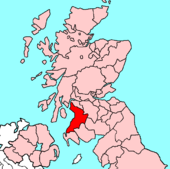
Ayrshire is a shire in Lowland Scotland, along the coast of the Firth of Clyde. Ayrshire is tradtionally divided from north to south into three bailieries:
- Cunninghame
- Kyle
- Carrick
Ayrshire is one of the most agriculturally fertile regions of Scotland. Potatoes are grown in fields near the coast, using seaweed-based fertiliser, and in addition the county produces pork products, other root vegetables, cattle and summer berries such as strawberries are grown abundantly.
Ayrshire shares with Wigtownshire and Kirkcudbrightshire to the south some wonderful rugged hill country known as the Galloway Hills. These hill lie to the west of the A713 (Ayr to Castle Douglas road) and they run south from the Loch Doon area almost to the Solway Firth. To the east of this route through the hills lie the Carsphairn and Scaur Hills which lie to the south east of Dalmellington and south of New Cumnock. Glen Afton runs deep into these hills.
The county used to be heavily industrialised, with steel making, coal mining and in Kilmarnock numerous examples of production-line manufacturing, most famously Johnnie Walker whisky. In more recent history, Digital Equipment had a large manufacturing plant near Ayr from about 1976 until the company was taken over by Compaq in 1998. Some supplier companies grew up to service this site and the more distant IBM plant at Greenock in Renfrewshire. Scotland's aviation industry has long been based in and around Prestwick and its international airport, and although aircraft manufacture ceased at the former British Aerospace plant in 1998, a significant number of aviation companies are still based on the Prestwick site. However, unemployment in the region (excluding the more rural south Ayrshire) remains high, above the national average.
Towns and villages
Parishes
- Ardrossan
- Auchinleck
- Ayr
- Ballantrae
- Barr
- Beith
- Colmonell
- Coylton
- Craigie
- Dailly
- Dalmellington
- Dalry
- Dalrymple
- Dreghorn
- Dundonald
- Dunlop
- Fenwick
- Galston
- Girvan
- Irvine
- Kilbirnie
- Kilmarnock
- Kilmaurs
- Kilwinning
- Kirkmichael
- Kirkoswald
- Largs
- Loudoun
- Mauchline
- Maybole
- Monkton and Prestwick
- Muirkirk
- New Cumnock
- Ochiltree
- Old Cumnock
- Riccarton
- Sorn
- Stair
- Stevenston
- Stewarton
- Straiton
- Symington
- Tarbolton
- West Kilbride
This county article is a stub: help to improve Wikishire by building it up.
| Counties of the United Kingdom |
|---|
|
Aberdeen • Anglesey • Angus • Antrim • Argyll • Armagh • Ayr • Banff • Bedford • Berks • Berwick • Brecknock • Buckingham • Bute • Caernarfon • Caithness • Cambridge • Cardigan • Carmarthen • Chester • Clackmannan • Cornwall • Cromarty • Cumberland • Denbigh • Derby • Devon • Dorset • Down • Dumfries • Dunbarton • Durham • East Lothian • Essex • Fermanagh • Fife • Flint • Glamorgan • Gloucester • Hants • Hereford • Hertford • Huntingdon • Inverness • Kent • Kincardine • Kinross • Kirkcudbright • Lanark • Lancaster • Leicester • Lincoln • Londonderry • Merioneth • Middlesex • Midlothian • Monmouth • Montgomery • Moray • Nairn • Norfolk • Northampton • Northumberland • Nottingham • Orkney • Oxford • Peebles • Pembroke • Perth • Radnor • Renfrew • Ross • Roxburgh • Rutland • Selkirk • Shetland • Salop • Somerset • Stafford • Stirling • Suffolk • Surrey • Sussex • Sutherland • Tyrone • Warwick • West Lothian • Westmorland • Wigtown • Wilts • Worcester • York |