Suffolk: Difference between revisions
No edit summary |
No edit summary |
||
| Line 13: | Line 13: | ||
Suffolk's long border with its northern neighbour Norfolk is marked by the River [[Little Ouse]] from its source to the [[Great Ouse]] to the west; and by the [[River Waveney]] from its source to the sea, the two rivers rising within yards of each other in Little Fen and flowing in opposite directions. Suffolk's border with [[Essex]] is marked by the [[River Stour, Essex and Suffolk|River Stour]] from [[Haverhill]] near the county's western border to the Stour Estuary and the sea. It also has a border in the west with [[Cambridgeshire]]. The [[North Sea]] washes its flat, eastern shore. Here is found the easternmost point of the United Kingdom; [[Lowestoft#Lowestoft Ness|Lowestoft Ness]], beyond which lies only the sea, empty of any further islands. | Suffolk's long border with its northern neighbour Norfolk is marked by the River [[Little Ouse]] from its source to the [[Great Ouse]] to the west; and by the [[River Waveney]] from its source to the sea, the two rivers rising within yards of each other in Little Fen and flowing in opposite directions. Suffolk's border with [[Essex]] is marked by the [[River Stour, Essex and Suffolk|River Stour]] from [[Haverhill]] near the county's western border to the Stour Estuary and the sea. It also has a border in the west with [[Cambridgeshire]]. The [[North Sea]] washes its flat, eastern shore. Here is found the easternmost point of the United Kingdom; [[Lowestoft#Lowestoft Ness|Lowestoft Ness]], beyond which lies only the sea, empty of any further islands. | ||
The [[county town]] of Suffolk is [[Ipswich]], an ancient seaport which remains the county's largest town. Other important towns include Lowestoft, Bury St Edmunds and Felixstowe, one of the largest container ports in Europe.<ref>[http://www.dft.gov.uk/pgr/shippingports/ports/ir/felixstowesouth/felixstowesouthreconfigurati4953?page=12 Felixstowe South reconfiguration inspector's report] Department for Transport</ref> [[Newmarket, Suffolk|Newmarket]], the home of horse-racing, is in the west of the county, in a bubble surrounded by Cambridgeshire. | The [[county town]] of Suffolk is [[Ipswich]], an ancient seaport which remains the county's largest town. Other important towns include [[Lowestoft]], [[Bury St Edmunds]] and [[Felixstowe]], one of the largest container ports in Europe.<ref>[http://www.dft.gov.uk/pgr/shippingports/ports/ir/felixstowesouth/felixstowesouthreconfigurati4953?page=12 Felixstowe South reconfiguration inspector's report] Department for Transport</ref> [[Newmarket, Suffolk|Newmarket]], the home of horse-racing, is in the west of the county, in a bubble surrounded by Cambridgeshire. | ||
The county is low-lying with few hills; the highest point of the county is Great Wood Hill, the highest point of the Newmarket Ridge in the very west of the county near the village of [[Rede]], which reaches 420 feet. The rest of the county is largely arable land and wetland habitats. The wetlands of [[The Broads]] cover much of the north-east of Suffolk and large parts of Norfolk. The Suffolk Coast and Heaths are an "Area of Outstanding Natural Beauty". | The county is low-lying with few hills; the highest point of the county is Great Wood Hill, the highest point of the Newmarket Ridge in the very west of the county near the village of [[Rede]], which reaches 420 feet. The rest of the county is largely arable land and wetland habitats. The wetlands of [[The Broads]] cover much of the north-east of Suffolk and large parts of Norfolk. The Suffolk Coast and Heaths are an "Area of Outstanding Natural Beauty". | ||
| Line 27: | Line 27: | ||
*[[Bury St Edmunds]] | *[[Bury St Edmunds]] | ||
*[[Hadleigh, Suffolk|Hadleigh]] | *[[Hadleigh, Suffolk|Hadleigh]] | ||
*[[Felixstowe]] | |||
*[[Haverhill]] ''(partly in [[Essex]])'' | *[[Haverhill]] ''(partly in [[Essex]])'' | ||
*[[Ipswich]] ''([[county town]])'' | *[[Ipswich]] ''([[county town]])'' | ||
Latest revision as of 14:07, 12 April 2024
| Suffolk United Kingdom | |
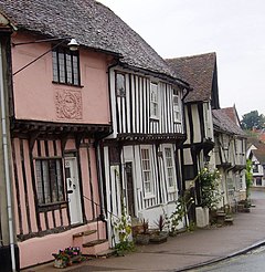 Lavenham | |
|---|---|

| |
| Flag | |
| Opus Nostrum Dirige (Direct our work) | |
| |
| [Interactive map] | |
| Area: | 1,489 square miles |
| Population: | 775,099 |
| County town: | Ipswich |
| County flower: | Oxlip [1] |
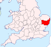
The County of Suffolk is a shire of East Anglia, which along with Norfolk, is one of only two counties entirely east of the Prime Meridian.
Suffolk's long border with its northern neighbour Norfolk is marked by the River Little Ouse from its source to the Great Ouse to the west; and by the River Waveney from its source to the sea, the two rivers rising within yards of each other in Little Fen and flowing in opposite directions. Suffolk's border with Essex is marked by the River Stour from Haverhill near the county's western border to the Stour Estuary and the sea. It also has a border in the west with Cambridgeshire. The North Sea washes its flat, eastern shore. Here is found the easternmost point of the United Kingdom; Lowestoft Ness, beyond which lies only the sea, empty of any further islands.
The county town of Suffolk is Ipswich, an ancient seaport which remains the county's largest town. Other important towns include Lowestoft, Bury St Edmunds and Felixstowe, one of the largest container ports in Europe.[1] Newmarket, the home of horse-racing, is in the west of the county, in a bubble surrounded by Cambridgeshire.
The county is low-lying with few hills; the highest point of the county is Great Wood Hill, the highest point of the Newmarket Ridge in the very west of the county near the village of Rede, which reaches 420 feet. The rest of the county is largely arable land and wetland habitats. The wetlands of The Broads cover much of the north-east of Suffolk and large parts of Norfolk. The Suffolk Coast and Heaths are an "Area of Outstanding Natural Beauty".
Towns and villages
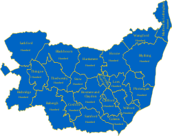
Suffolk has a mixture of modest towns, villages and many scattered hamlets. Many of the towns have a rich history, for in Anglo-Saxon times Suffolk was the heart of the Kingdom of East Anglia and later at the forefront of the Danish incursions, and during the later Middle Ages amongst these little towns a great deal of wealth was found from wool (hence the great "wool churches" such as that in Lavenham). The oldest documented structural element of a still inhabited dwelling in Britain is found in Clare.
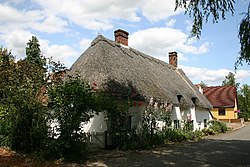
Most of all, Suffolk is known for its pretty villages, featuring in many a painting. The villages abound with broad greens, thatched cottages brightly painted, and that particular East Anglian art, pargeting (shaped plaster).
The largest towns are:
- Brandon
- Bury St Edmunds
- Hadleigh
- Felixstowe
- Haverhill (partly in Essex)
- Ipswich (county town)
- Lowestoft
- Mildenhall
- Newmarket (partly in Cambridgeshire)
- Stowmarket
- Sudbury
- Woodbridge
Additionally, parts of the towns of Great Yarmouth and Thetford, otherwise in Norfolk extend into Suffolk.
Geology, landscape and ecology
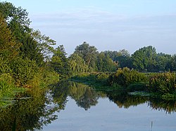
Much of Suffolk is low-lying on Eocene sand and clays. These rocks are relatively unresistant and the coast is eroding rapidly. The major town of Dunwich has been almost entirely washed away over the ages. Coastal defences have been used to protect several towns, but several cliff-top houses have been lost to coastal erosion in the past, and others are under threat. The continuing protection of the coastline and the estuaries, including the Blyth, Alde and Deben, has been, and remains, a matter of considerable discussion.[2]
The coastal strip to the East contains an area of heathland known as "The Sandlings" which runs almost the full length of the coastline.[3]
The west of the county lies on more resistant Cretaceous chalk. This chalk is the north-eastern extreme of the Southern England Chalk Formation that stretches from Dorset in the south-west to Dover in the south-east. The Chalk is less easily eroded so forms the only significant hills in the county.
Archaeology
Western Suffolk is, like nearby eastern Cambridgeshire, renowned for archaeological finds from the Stone Age, the Bronze Age and the Iron Age. Bronze Age artefacts have been found in the area between Mildenhall and West Row, in Eriswell and in Lakenheath[4]. Many bronze objects, such as swords, spearheads, arrows, axes, palstaves, knives, daggers, rapiers, armour, decorative equipment (in particular for horses) and fragments of sheet bronze, are entrusted to the Moyse's Hall Museum in Bury St Edmunds. Other finds include traces of cremations and barrows.
Sutton Hoo
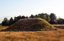
Sutton Hoo in the east of the county is the site of one of England's most significant Anglo-Saxon archæological finds. Here, buried within a man-made mound, was found a ship burial containing a rich collection of treasures. Little trace of the ship itself was found, and no trace of the body, long since rotted away, but the remains of armour, jewellery, drinking vessels, gold and silver bowls and a lyre were found, together with some objects defying complete interpretation.
The place is assumed to be the burial place of an East Anglian king, possibly Rædwald the Bretwalda, thus placing his capital within this part of Suffolk.
Economy
The majority of agriculture in Suffolk is either arable or mixed. Farm sizes vary from anything around 80 acres to over 8,000. Soil types vary from heavy clays through to light sands. Crops grown include winter wheat, winter barley, sugar beet, oilseed rape, winter and spring beans and linseed, although smaller areas of rye and oats can be found in lighter areas along with a variety of vegetables.
The continuing importance of agriculture in the county is reflected in the Suffolk Show, which is held annually in May at Ipswich. Although latterly somewhat changed in nature, this remains primarily an agricultural show.
Horse racing
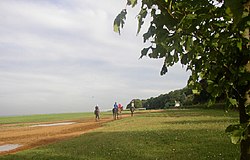
The town of Newmarket is the headquarters of British horseracing. Here is found the largest cluster of training yards in the country, many key horse racing organisations, including the National Stud,[5] and Newmarket Racecourse.
Tattersalls bloodstock auctioneers and the National Horseracing Museum are also in the town. Point to point racing takes place at Higham and Ampton.[6]
Places of interest
| Key | |
| Cathedral/Abbey/Priory | |
| Accessible open space | |
| Amusement/Theme Park | |
| Castle | |
| Country Park | |
| English Heritage | |
| Forestry Commission | |
| Heritage railway | |
| Historic House | |
| Museum (free/not free) | |
| National Trust | |
| Zoo | |
- Aldeburgh
- Bawdsey
- Bridge Cottage, Flatford Mill
- Bury St Edmunds
 Bungay Castle
- Clare
 Clare Castle
- Dedham Vale
 East Anglia Transport Museum
- Easton Farm Park
 Framlingham Castle
- Great Barton
- Hadleigh
 Ickworth House
- Ipswich Town Centre
- Kersey
- Lavenham
- Leiston Abbey
- Little Bealings
- Long Melford
- Lowestoft
 Mid-Suffolk Light Railway
 Museum of East Anglian Life
 Norfolk and Suffolk Aviation Museum
- Lowestoft Ness; Britain's most easterly point
 National Horse Racing Museum, Newmarket
- Orford Ness
- Otter Trust
- Rougham Airfield
- RSPB Minsmere
- RSPB Stour Estuary
 St Edmundsbury Cathedral and Abbey ruins
- Saxtead Green Post Mill
- Snape Maltings
- Southwold Lighthouse
- St Mary's Church, Bungay
 Sue Ryder Foundation Museum
- Suffolk Coast and Heaths Path
- Suffolk Heritage Coast
 Sutton Hoo
- The Broads
- The Historic villages of Lavenham and Long Melford
- Thorpeness
- West Stow Anglo-Saxon Village
- Woodbridge
See also
References
- ↑ Felixstowe South reconfiguration inspector's report Department for Transport
- ↑ "Sea Defences to be saved" East Anglian Daily Times - 29th October 2008
- ↑ Suffolk Coast and Heaths
- ↑ Hall, David. Fenland survey : an essay in landscape and persistence / David Hall and John Coles. London; English Heritage. ISBN 1-85074-477-7., p. 81-88
- ↑ "Suffolk Tourism". www.suffolktouristguide.com. http://www.suffolktouristguide.com/. Retrieved 2009-02-02.
- ↑ "Courses". www.pointingea.com. http://www.pointingea.com/courses/courses.htm. Retrieved 2008-04-14.
Outside links
| Counties of the United Kingdom |
|---|
|
Aberdeen • Anglesey • Angus • Antrim • Argyll • Armagh • Ayr • Banff • Bedford • Berks • Berwick • Brecknock • Buckingham • Bute • Caernarfon • Caithness • Cambridge • Cardigan • Carmarthen • Chester • Clackmannan • Cornwall • Cromarty • Cumberland • Denbigh • Derby • Devon • Dorset • Down • Dumfries • Dunbarton • Durham • East Lothian • Essex • Fermanagh • Fife • Flint • Glamorgan • Gloucester • Hants • Hereford • Hertford • Huntingdon • Inverness • Kent • Kincardine • Kinross • Kirkcudbright • Lanark • Lancaster • Leicester • Lincoln • Londonderry • Merioneth • Middlesex • Midlothian • Monmouth • Montgomery • Moray • Nairn • Norfolk • Northampton • Northumberland • Nottingham • Orkney • Oxford • Peebles • Pembroke • Perth • Radnor • Renfrew • Ross • Roxburgh • Rutland • Selkirk • Shetland • Salop • Somerset • Stafford • Stirling • Suffolk • Surrey • Sussex • Sutherland • Tyrone • Warwick • West Lothian • Westmorland • Wigtown • Wilts • Worcester • York |