Difference between revisions of "Argyll"
m (moved Argyll to Argyllshire over redirect: HCS standard name) |
|||
| Line 5: | Line 5: | ||
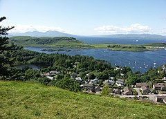
|picture caption= Druim Mor | |picture caption= Druim Mor | ||
|area=3,110 square miles | |area=3,110 square miles | ||
| − | |population= | + | |population={{hcspop|05}} |
|county town=[[Inverary]] | |county town=[[Inverary]] | ||
}} | }} | ||
| Line 11: | Line 11: | ||
'''Argyll''' or '''Argyllshire''' is a [[Counties of the United Kingdom|county]] of mountains, peninsulas and islands. It encompasses most of the [[Inner Hebrides#Hebrides|Inner Hebrides]]. | '''Argyll''' or '''Argyllshire''' is a [[Counties of the United Kingdom|county]] of mountains, peninsulas and islands. It encompasses most of the [[Inner Hebrides#Hebrides|Inner Hebrides]]. | ||
| − | + | ==Towns and villages== | |
| + | *[[Lochgilphead]] | ||
| + | *[[Campbeltown]] | ||
| + | *[[Dunoon]] | ||
| + | *[[Inveraray]] | ||
| + | *[[Oban]] | ||
| + | *[[Tobermory]] | ||
| + | ==Parishes== | ||
| + | {{parishliststart}} | ||
| + | *[[Ardchattan and Muckairn]] | ||
| + | *[[Ardgour]] | ||
| + | *[[Ardnamurchan]] | ||
| + | *[[Campbeltown]] | ||
| + | *[[Coll]] | ||
| + | *[[Colonsay and Oronsay]] | ||
| + | *[[Craignish]] | ||
| + | *[[Dunoon and Kilmun]] | ||
| + | *[[Gigha and Cara]] | ||
| + | *[[Glassary]] | ||
| + | *[[Glenorchy and Inishail]] | ||
| + | *[[Inveraray]] | ||
| + | *[[Inverchaolain]] | ||
| + | *[[Jura]] | ||
| + | *[[Kilbrandon and Kilchattan]] | ||
| + | *[[Kilcalmonell]] | ||
| + | *[[Kilchoman]] | ||
| + | *[[Kilchrenan and Dalavich]] | ||
| + | *[[Kildalton]] | ||
| + | *[[Kilfinan]] | ||
| + | *[[Kilfinichen and Kilvickeon]] | ||
| + | *[[Killarow and Kilmeny]] | ||
| + | *[[Killean and Kilchenzie]] | ||
| + | *[[Kilmartin]] | ||
| + | *[[Kilmodan]] | ||
| + | *[[Kilmore and Kilbride]] | ||
| + | *[[Kilninian and Kilmore]] | ||
| + | *[[Kilninver and Kilmelfort]] | ||
| + | *[[Lismore and Appin]] | ||
| + | *[[Lochgoilhead and Kilmorich]] | ||
| + | *[[Morvern]] | ||
| + | *[[North Knapdale]] | ||
| + | *[[Saddell and Skipness]] | ||
| + | *[[South Knapdale]] | ||
| + | *[[Southend]] | ||
| + | *[[Strachur]] | ||
| + | *[[Strathlachlan]] | ||
| + | *[[Tiree]] | ||
| + | *[[Torosay]] | ||
| + | {{parishlistend}} | ||
| + | |||
| + | {{stub}} | ||
{{British county}} | {{British county}} | ||
Revision as of 12:32, 12 August 2010
| Argyllshire United Kingdom | |
 Druim Mor | |
|---|---|

| |
| [Interactive map] | |
| Area: | 3,110 square miles |
| Population: | Template:Hcspop |
| County town: | Inverary |
| County flower: | Foxglove [1] |
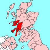
Argyll or Argyllshire is a county of mountains, peninsulas and islands. It encompasses most of the Inner Hebrides.
Towns and villages
Parishes
- Ardchattan and Muckairn
- Ardgour
- Ardnamurchan
- Campbeltown
- Coll
- Colonsay and Oronsay
- Craignish
- Dunoon and Kilmun
- Gigha and Cara
- Glassary
- Glenorchy and Inishail
- Inveraray
- Inverchaolain
- Jura
- Kilbrandon and Kilchattan
- Kilcalmonell
- Kilchoman
- Kilchrenan and Dalavich
- Kildalton
- Kilfinan
- Kilfinichen and Kilvickeon
- Killarow and Kilmeny
- Killean and Kilchenzie
- Kilmartin
- Kilmodan
- Kilmore and Kilbride
- Kilninian and Kilmore
- Kilninver and Kilmelfort
- Lismore and Appin
- Lochgoilhead and Kilmorich
- Morvern
- North Knapdale
- Saddell and Skipness
- South Knapdale
- Southend
- Strachur
- Strathlachlan
- Tiree
- Torosay
This county article is a stub: help to improve Wikishire by building it up.
| Counties of the United Kingdom |
|---|
|
Aberdeen • Anglesey • Angus • Antrim • Argyll • Armagh • Ayr • Banff • Bedford • Berks • Berwick • Brecknock • Buckingham • Bute • Caernarfon • Caithness • Cambridge • Cardigan • Carmarthen • Chester • Clackmannan • Cornwall • Cromarty • Cumberland • Denbigh • Derby • Devon • Dorset • Down • Dumfries • Dunbarton • Durham • East Lothian • Essex • Fermanagh • Fife • Flint • Glamorgan • Gloucester • Hants • Hereford • Hertford • Huntingdon • Inverness • Kent • Kincardine • Kinross • Kirkcudbright • Lanark • Lancaster • Leicester • Lincoln • Londonderry • Merioneth • Middlesex • Midlothian • Monmouth • Montgomery • Moray • Nairn • Norfolk • Northampton • Northumberland • Nottingham • Orkney • Oxford • Peebles • Pembroke • Perth • Radnor • Renfrew • Ross • Roxburgh • Rutland • Selkirk • Shetland • Salop • Somerset • Stafford • Stirling • Suffolk • Surrey • Sussex • Sutherland • Tyrone • Warwick • West Lothian • Westmorland • Wigtown • Wilts • Worcester • York |