Clackmannanshire: Difference between revisions
No edit summary |
No edit summary |
||
| (17 intermediate revisions by 4 users not shown) | |||
| Line 1: | Line 1: | ||
{{Infobox county | {{Infobox county | ||
|name=Clackmannanshire | |name=Clackmannanshire | ||
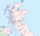
|map image= | |map image=Clackmannanshire Brit Isles Sect 2.svg | ||
|picture= | |picture="Burn of Care" near Castle Campbell - geograph.org.uk - 1482415.jpg | ||
|picture caption= | |picture caption=Burn of Care near Castle Campbell | ||
|county town=[[Dollar, Clackmannanshire|Dollar]] | |county town=[[Dollar, Clackmannanshire|Dollar]] | ||
}} | }} | ||
The '''County of Clackmannan''' (abbreviated '''Clacks.''') is a [[Counties of the United Kingdom|shire]] in Central Scotland. It is the smallest county of the United Kingdom, reflected in its nickname; ''the wee county''. | |||
Clackmannanshire lies between [[Perthshire]] to the north and [[Fife]] to the south, while [[Stirlingshire]] is to the west. [[Kinross-shire]], a county almost as small, adjoins Clackmannanshire to the east. A small, detached part of Perthshire also lies to the south. Clackmannanshire itself has a detached part to the south-west in a crook of the [[River Forth]] adjacent to [[Stirling]] on the opposite bank. | |||
{{ | The county's name comes from that of its original county town, [[Clackmannan]], which in turn takes its name from the Gaelic ''Clach Mhannainn'' meaning "Stone of Manau". Clackmannanshire's current [[county town]] is [[Dollar]] and its main town [[Alloa]], where about half of the shire's population live. | ||
Clackmannanshire has adopted a motto; ''Look Aboot Ye'', a rich Scots adaptation of the Latin motto ''Circumspice''. | |||
==Geography== | |||
[[File:Alva Glen - geograph.org.uk - 492438.jpg||thumb|250px|Alva Glen]] | |||
With just 35,160 acres (55 square miles), Clackmannanshire is the smallest county in the United Kingdom, but full of beauty. | |||
The [[Ochil Hills]] lie in [[Strathdevon]] in the northern part of the county. These pretty hills are green with pasture, broken in places with jutting rocks and deeply indented ravines. Here are the greatest hills of Clackmannanshire, notably: | |||
*[[Ben Cleuch]] (2,365 feet) – the [[county top]] | |||
*[[King's Seat]] (2,111 feet) | |||
*[[Whitewisp Hill]] (2,110 feet.) | |||
*The Law - above [[Tillicoultry]] (2,094 feet) | |||
*Blairdenon (2,072 feet) | |||
The county's main river, the [[River Devon, Clackmannanshire|River Devon]] rises on these hills. | |||
South of the Ochils themselves, an elevated ridge starting on the west, runs through the middle of the county, widening gradually until it reaches the eastern boundary, and skirting the alluvial or carse lands in the valleys of the [[River Forth|Forth]] and [[River Devon, Clackmannanshire|Devon]]. | |||
The Ochils are noted for the number of their glens. Though these are mostly small, they are well wooded and picturesque, and those at [[Menstrie]], [[Alva]], [[Tillicoultry]] and [[Dollar]] are particularly beautiful. | |||
The main rivers of the shire are the [[River Devon, Clackmannanshire|River Devon]] and the [[River Black Devon]], or South Devon. The former is noted in the upper parts for its romantic scenery and its excellent trout-fishing and from its source in the Ochill Hills is flows 33 miles below the hills and down to the Forth at [[Cambus]], though still just 5¼ miles from its source as the crown flies. Strathdevon is the lowland plain a few hundred yards either side of the River Devon, and this goes on to contribute to the formation the valley of the River Forth. | |||
The Black Devon rises in the Cleish Hills and flows westwards almost parallel to that of the Devon. It reaches the Forth near Clackmannan. | |||
The Forth is navigable as far as it forms the boundary of the county, and ships of 500 tons burden would once run up to Alloa. At the meeting of the Devon and the Forth there was small pier for portage to Dunmore pier and anchorage of smaller sailing ships, where others of more tonnage could be accepted at Dunmore pier on the opposite banks of the Forth. | |||
The county's only lake is a man-made one: [[Gartmorn Dam]], a mile long and half a mile broad. | |||
==Economy== | |||
The main industries are agriculture, brewing, and formerly coal mining. In 2006, permission was given for a waterfront development of the Docks area of Alloa, which has been in decline since the 1960s. | |||
Alloa railway station reopened in May 2008. A new railway line connecting Kincardine and Stirling, reconnecting Alloa to the national rail network for the first time since 1968 was opened to the public. Passenger services only operate towards Stirling, the line to Kincardine is for freight trains only. An opening ceremony was held on Thursday 15 May, with the first fully functioning passenger service commencing in the new summer timetable on 19 May 2008.<ref>[http://www.clacksweb.org.uk/transport/railways/ Railway information | Clackmannanshire Council]</ref><ref>[http://www.clacksweb.org.uk/council/press/?release=1788 Stirling Alloa Kincardine Railway celebrates first anniversary | ClacksWeb]</ref> The service provides an hourly connection between Alloa, Stirling and Glasgow Queen Street. | |||
==History== | |||
Clackmannan, the old county town, is named after an ancient stone suggested by some to be associated with a pre-Christian deity named ''Manau'' or ''Mannan''<ref>http://commons.wikimedia.org/wiki/File:Clackmannan_sign_about_stone,_cross_and_tollbooth.jpg</ref> or with the tribe of the ''Manau Gododdin'', best associated with the Lothians in the Dark Ages. The presumed original stone now rests on a larger stone beside the Tollbooth and Mercat Cross at the top of Main Street, Clackmannan. | |||
Legend has it that Robert the Bruce mislaid his glove while in the area and, on asking where it was, was told "Look aboot ye". The county's coat of arms shows a pair of gloves. | |||
Clackmannanshire became known for the weaving mills powered by the Hillfoots burns. Other industries included brewing, glass manufacture, mining and ship building. | |||
Now capitalising on its central position and transport links, Clackmannanshire attracts service industries and tourism. | |||
==Towns and villages== | |||
[[File:Cairnpark Street, Dollar - geograph.org.uk - 293262.jpg|right|thumb|250px|Dollar]] | |||
{| | |||
|width="30%" valign="top"| | |||
*[[Alloa]] | |||
*[[Alva]] | |||
*[[Clackmannan]] | |||
*[[Coalsnaughton]] | |||
*[[Devonside]] | |||
*[[Dollar]] | |||
|width="30%" valign="top"| | |||
*[[Fishcross]] | |||
*[[Menstrie]] | |||
*[[Sauchie]] | |||
*[[Tillicoultry]] | |||
*[[Tullibody]] | |||
|} | |||
===Parishes=== | |||
{{parishliststart}} | |||
*[[Alloa]] | |||
*[[Alva]] | |||
*[[Clackmannan]] | |||
*[[Dollar]] | |||
*[[Tillicoultry]] | |||
{{parishlistend}} | |||
==Places of interest== | |||
[[File:Castle Campbell 09.jpg|right|thumb|250px|Castle Campbell]] | |||
{{UKPlacesKey}} | |||
*[[Alloa Tower]] | |||
*[[Ben Cleuch]] | |||
*{{i-Castle}} [[Castle Campbell]] | |||
*{{i-Abbey}} Cambuskenneth Abbey (erstwhile seat of the Parliament of Scotland) | |||
*[[Gartmorn Dam]] | |||
*{{i-Castle}} [[Menstrie Castle]] | |||
==Outside links== | |||
*[http://www.clacksnet.org.uk ClacksNet] - Clackmannanshire's Community Network | |||
*[http://www.nls.uk/digitallibrary/map/early/record.cfm?id=69 National Library of Scotland - Clackmannanshire Map ca. 1681] | |||
*[http://www.lookabootye.co.uk/ Look Aboot Ye - Clackmannanshire Community News, Information and Forums] | |||
==References== | |||
{{reflist}} | |||
===Books and sources=== | |||
*Wallace, James: "The Sheriffdom of Clackmannan: a Sketch of its History" (Edinburgh, 1890) | |||
*Beveridge, D: "Between the Ochils and the Forth" (Edinburgh, 1888) | |||
*Crawford, John: "Memorials of Alloa" (1885) | |||
*Gibson, William: "Reminiscences of Dollar, Tillicoultry" | |||
*[http://www.snh.org.uk/publications/on-line/LCA/clackmannanshire.pdf ASH Consulting Group 1998. Clackmannanshire landscape character assessment. Scottish Natural Heritage Review No 96.] | |||
{{British county}} | {{British county}} | ||
Latest revision as of 13:30, 16 January 2018
| Clackmannanshire United Kingdom | |
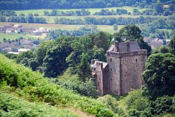
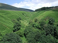 Burn of Care near Castle Campbell | |
|---|---|
| Look Aboot Ye | |
| |
| [Interactive map] | |
| Area: | 48 square miles |
| Population: | 50,957 |
| County town: | Dollar |
| County flower: | Opposite-leaved golden saxifrage [1] |
The County of Clackmannan (abbreviated Clacks.) is a shire in Central Scotland. It is the smallest county of the United Kingdom, reflected in its nickname; the wee county.
Clackmannanshire lies between Perthshire to the north and Fife to the south, while Stirlingshire is to the west. Kinross-shire, a county almost as small, adjoins Clackmannanshire to the east. A small, detached part of Perthshire also lies to the south. Clackmannanshire itself has a detached part to the south-west in a crook of the River Forth adjacent to Stirling on the opposite bank.
The county's name comes from that of its original county town, Clackmannan, which in turn takes its name from the Gaelic Clach Mhannainn meaning "Stone of Manau". Clackmannanshire's current county town is Dollar and its main town Alloa, where about half of the shire's population live.
Clackmannanshire has adopted a motto; Look Aboot Ye, a rich Scots adaptation of the Latin motto Circumspice.
Geography
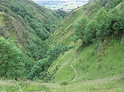
With just 35,160 acres (55 square miles), Clackmannanshire is the smallest county in the United Kingdom, but full of beauty.
The Ochil Hills lie in Strathdevon in the northern part of the county. These pretty hills are green with pasture, broken in places with jutting rocks and deeply indented ravines. Here are the greatest hills of Clackmannanshire, notably:
- Ben Cleuch (2,365 feet) – the county top
- King's Seat (2,111 feet)
- Whitewisp Hill (2,110 feet.)
- The Law - above Tillicoultry (2,094 feet)
- Blairdenon (2,072 feet)
The county's main river, the River Devon rises on these hills.
South of the Ochils themselves, an elevated ridge starting on the west, runs through the middle of the county, widening gradually until it reaches the eastern boundary, and skirting the alluvial or carse lands in the valleys of the Forth and Devon.
The Ochils are noted for the number of their glens. Though these are mostly small, they are well wooded and picturesque, and those at Menstrie, Alva, Tillicoultry and Dollar are particularly beautiful.
The main rivers of the shire are the River Devon and the River Black Devon, or South Devon. The former is noted in the upper parts for its romantic scenery and its excellent trout-fishing and from its source in the Ochill Hills is flows 33 miles below the hills and down to the Forth at Cambus, though still just 5¼ miles from its source as the crown flies. Strathdevon is the lowland plain a few hundred yards either side of the River Devon, and this goes on to contribute to the formation the valley of the River Forth.
The Black Devon rises in the Cleish Hills and flows westwards almost parallel to that of the Devon. It reaches the Forth near Clackmannan.
The Forth is navigable as far as it forms the boundary of the county, and ships of 500 tons burden would once run up to Alloa. At the meeting of the Devon and the Forth there was small pier for portage to Dunmore pier and anchorage of smaller sailing ships, where others of more tonnage could be accepted at Dunmore pier on the opposite banks of the Forth.
The county's only lake is a man-made one: Gartmorn Dam, a mile long and half a mile broad.
Economy
The main industries are agriculture, brewing, and formerly coal mining. In 2006, permission was given for a waterfront development of the Docks area of Alloa, which has been in decline since the 1960s.
Alloa railway station reopened in May 2008. A new railway line connecting Kincardine and Stirling, reconnecting Alloa to the national rail network for the first time since 1968 was opened to the public. Passenger services only operate towards Stirling, the line to Kincardine is for freight trains only. An opening ceremony was held on Thursday 15 May, with the first fully functioning passenger service commencing in the new summer timetable on 19 May 2008.[1][2] The service provides an hourly connection between Alloa, Stirling and Glasgow Queen Street.
History
Clackmannan, the old county town, is named after an ancient stone suggested by some to be associated with a pre-Christian deity named Manau or Mannan[3] or with the tribe of the Manau Gododdin, best associated with the Lothians in the Dark Ages. The presumed original stone now rests on a larger stone beside the Tollbooth and Mercat Cross at the top of Main Street, Clackmannan.
Legend has it that Robert the Bruce mislaid his glove while in the area and, on asking where it was, was told "Look aboot ye". The county's coat of arms shows a pair of gloves.
Clackmannanshire became known for the weaving mills powered by the Hillfoots burns. Other industries included brewing, glass manufacture, mining and ship building.
Now capitalising on its central position and transport links, Clackmannanshire attracts service industries and tourism.
Towns and villages
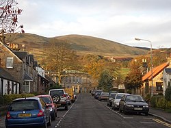
Parishes
Places of interest
| Key | |
| Cathedral/Abbey/Priory | |
| Accessible open space | |
| Amusement/Theme Park | |
| Castle | |
| Country Park | |
| Historic Scotland | |
| Forestry Commission | |
| Heritage railway | |
| Historic House | |
| Museum (free/not free) | |
| National Trust for Scotland | |
| Zoo | |
- Alloa Tower
- Ben Cleuch
 Castle Campbell
 Cambuskenneth Abbey (erstwhile seat of the Parliament of Scotland)
- Gartmorn Dam
 Menstrie Castle
Outside links
- ClacksNet - Clackmannanshire's Community Network
- National Library of Scotland - Clackmannanshire Map ca. 1681
- Look Aboot Ye - Clackmannanshire Community News, Information and Forums
References
Books and sources
- Wallace, James: "The Sheriffdom of Clackmannan: a Sketch of its History" (Edinburgh, 1890)
- Beveridge, D: "Between the Ochils and the Forth" (Edinburgh, 1888)
- Crawford, John: "Memorials of Alloa" (1885)
- Gibson, William: "Reminiscences of Dollar, Tillicoultry"
- ASH Consulting Group 1998. Clackmannanshire landscape character assessment. Scottish Natural Heritage Review No 96.
| Counties of the United Kingdom |
|---|
|
Aberdeen • Anglesey • Angus • Antrim • Argyll • Armagh • Ayr • Banff • Bedford • Berks • Berwick • Brecknock • Buckingham • Bute • Caernarfon • Caithness • Cambridge • Cardigan • Carmarthen • Chester • Clackmannan • Cornwall • Cromarty • Cumberland • Denbigh • Derby • Devon • Dorset • Down • Dumfries • Dunbarton • Durham • East Lothian • Essex • Fermanagh • Fife • Flint • Glamorgan • Gloucester • Hants • Hereford • Hertford • Huntingdon • Inverness • Kent • Kincardine • Kinross • Kirkcudbright • Lanark • Lancaster • Leicester • Lincoln • Londonderry • Merioneth • Middlesex • Midlothian • Monmouth • Montgomery • Moray • Nairn • Norfolk • Northampton • Northumberland • Nottingham • Orkney • Oxford • Peebles • Pembroke • Perth • Radnor • Renfrew • Ross • Roxburgh • Rutland • Selkirk • Shetland • Salop • Somerset • Stafford • Stirling • Suffolk • Surrey • Sussex • Sutherland • Tyrone • Warwick • West Lothian • Westmorland • Wigtown • Wilts • Worcester • York |