Difference between revisions of "Monmouthshire"
| Line 11: | Line 11: | ||
|flower=Foxglove | |flower=Foxglove | ||
}} | }} | ||
| − | + | '''Monmouthshire''' is a [[Counties of the United Kingdom|county]] in the southwest of [[Great Britain]]. The eastern part of the county is mainly agricultural, while rich mineral resources were discovered in the western valleys. This led to the area becoming highly industrialised with [[coal mining]] and iron working being major employers from the [[18th century]]<ref>{{cite web |url=http://www.visionofbritain.org.uk/place/place_page.jsp?p_id=17183 |title=Monmouthshire |accessdate=2008-08-24 |author=John Bartholomew |date=1887 |work=Gazetteer of the British Isles |publisher=Vision of Britain}}</ref> to the late 20th century. | |
| − | '''Monmouthshire''' is a [[Counties of the United Kingdom|county]] in the southwest of [[Great Britain]]. The eastern part of the county is mainly agricultural, while | + | |
[[Monmouth]] the county town, stands at the extreme northeast of the county, on the border with [[Herefordshire]], while the largest settlement and only city, [[Newport]] lies in the southern coastal belt. The highest point is ''Chwarel y Fan'' at 2,228 feet. | [[Monmouth]] the county town, stands at the extreme northeast of the county, on the border with [[Herefordshire]], while the largest settlement and only city, [[Newport]] lies in the southern coastal belt. The highest point is ''Chwarel y Fan'' at 2,228 feet. | ||
| Line 33: | Line 32: | ||
*[[Wentloog (hundred)|Wentloog]] | *[[Wentloog (hundred)|Wentloog]] | ||
| − | ===Towns | + | ===Cities=== |
| − | *[[Abergavenny]] | + | *[[Newport, Monmouthshire|Newport]] (51.588° N -2.998° E) |
| − | *[[Blackwood]] | + | |
| − | *[[Blaenavon]] | + | ===Towns=== |
| − | *[[Caldicot]] | + | *[[Abergavenny]] (51.824° N -3.017° E) |
| − | *[[Chepstow]] | + | *[[Blackwood, Monmouthshire|Blackwood]] (51.67° N -3.19° E) |
| − | *[[Cwmbran]] | + | *[[Blaenavon]] (51.773° N -3.0828° E) |
| − | *[[Ebbw Vale]] | + | *[[Caldicot, Monmouthshire|Caldicot]] (51.591° N -2.749° E) |
| − | *[[Monmouth]] | + | *[[Chepstow]] (51.642° N -2.675° E) |
| − | *[[Newbridge]] | + | *[[Cwmbran]] (51.653° N -3.021° E) |
| − | + | *[[Ebbw Vale]] (51.778° N -3.212° E) | |
| − | *[[Pontypool]] | + | *[[Monmouth]] (51.809° N -2.719° E) |
| − | *[[Rhymney]] | + | *[[Newbridge, Monmouthshire|Newbridge]] (51.670° N -3.136° E) |
| − | *[[Risca]] | + | *[[Pontypool]] (51.703° N -3.041° E) |
| − | *[[Tredegar]] | + | *[[Rhymney]] (51.749° N -3.283° E) |
| − | *[[Usk]] | + | *[[Risca]] (51.608° N -3.091° E) |
| + | *[[Tredegar]] (51.778° N -3.2407° E) | ||
| + | *[[Usk]] (51.704° N -2.902° E) | ||
==Transport== | ==Transport== | ||
Revision as of 10:58, 18 August 2010
| Monmouthshire Welsh: Sir Fynwy United Kingdom | |
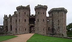
 Raglan Castle | |
|---|---|

| |
| Flag | |
| Utrique Fidelis (Faithful to both) | |

| |
| [Interactive map] | |
| Area: | 530 square miles |
| Population: | 503,917 |
| County town: | Monmouth |
| Biggest town: | Newport |
| County flower: | Foxglove [1] |
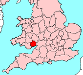
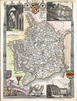
Monmouthshire is a county in the southwest of Great Britain. The eastern part of the county is mainly agricultural, while rich mineral resources were discovered in the western valleys. This led to the area becoming highly industrialised with coal mining and iron working being major employers from the 18th century[1] to the late 20th century.
Monmouth the county town, stands at the extreme northeast of the county, on the border with Herefordshire, while the largest settlement and only city, Newport lies in the southern coastal belt. The highest point is Chwarel y Fan at 2,228 feet.
Geography
Monmouthshire lies to the north of the Severn Estuary, which forms the county's southern boundary. Three other rivers form the majority of the county's other boundaries: The river Wye forms the eastern boundary with Gloucestershire, the river Rhymney forms the western boundary with Glamorgan and the river Monnow forms the northeastern border with Herefordshire. The Brecon Beacons form the northern boundary with Brecknockshire.
The parish of Welsh Bicknor is an exclave of Monmouthshire, sandwiched between Gloucestershire and Herefordshire. The Herefordshire hamlet of Fwthog adjoining the Honddu Valley is an exclave within Monmouthshire.
Hundreds

The county was divided into six hundreds in 1542:
Cities
- Newport (51.588° N -2.998° E)
Towns
- Abergavenny (51.824° N -3.017° E)
- Blackwood (51.67° N -3.19° E)
- Blaenavon (51.773° N -3.0828° E)
- Caldicot (51.591° N -2.749° E)
- Chepstow (51.642° N -2.675° E)
- Cwmbran (51.653° N -3.021° E)
- Ebbw Vale (51.778° N -3.212° E)
- Monmouth (51.809° N -2.719° E)
- Newbridge (51.670° N -3.136° E)
- Pontypool (51.703° N -3.041° E)
- Rhymney (51.749° N -3.283° E)
- Risca (51.608° N -3.091° E)
- Tredegar (51.778° N -3.2407° E)
- Usk (51.704° N -2.902° E)
Transport
Monmouthshire lies at the junction of major routes from South Wales to London and the Midlands. Major roads include the M4 motorway from London to West Wales, the parallel A40 and A48 routes and the A465 and A449 routes to the Midlands.
Princiapal rail routes converge on Newport, including the South Wales Main Line via the Severn Tunnel, the Gloucester to Newport Line, Welsh Marches Line and Ebbw Valley Line.
The Monmouthshire canal and the Brecknockshire and Abergavenny canal converge at Pontymoile near Pontypool.
References
- ↑ John Bartholomew (1887). "Monmouthshire". Gazetteer of the British Isles. Vision of Britain. http://www.visionofbritain.org.uk/place/place_page.jsp?p_id=17183. Retrieved 2008-08-24.
This county article is a stub: help to improve Wikishire by building it up.
| Counties of the United Kingdom |
|---|
|
Aberdeen • Anglesey • Angus • Antrim • Argyll • Armagh • Ayr • Banff • Bedford • Berks • Berwick • Brecknock • Buckingham • Bute • Caernarfon • Caithness • Cambridge • Cardigan • Carmarthen • Chester • Clackmannan • Cornwall • Cromarty • Cumberland • Denbigh • Derby • Devon • Dorset • Down • Dumfries • Dunbarton • Durham • East Lothian • Essex • Fermanagh • Fife • Flint • Glamorgan • Gloucester • Hants • Hereford • Hertford • Huntingdon • Inverness • Kent • Kincardine • Kinross • Kirkcudbright • Lanark • Lancaster • Leicester • Lincoln • Londonderry • Merioneth • Middlesex • Midlothian • Monmouth • Montgomery • Moray • Nairn • Norfolk • Northampton • Northumberland • Nottingham • Orkney • Oxford • Peebles • Pembroke • Perth • Radnor • Renfrew • Ross • Roxburgh • Rutland • Selkirk • Shetland • Salop • Somerset • Stafford • Stirling • Suffolk • Surrey • Sussex • Sutherland • Tyrone • Warwick • West Lothian • Westmorland • Wigtown • Wilts • Worcester • York |