Caithness
| Caithness United Kingdom | |

| |
|---|---|
| Flag | |
| Commit thy Wark to God | |

| |
| [Interactive map] | |
| Area: | 618 square miles |
| Population: | Template:Hcspop |
| County town: | Wick |
| County flower: | Scottish primrose [1] |
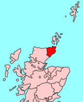
The County of Caithness is the land beyond the Highlands. It is a triangular shire at the north-eastern tip of Great Britain, bounded to the north and the east by the sea and to the west by Sutherland.
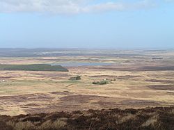
The land of Caithness is low-lying, in remarkable contrast to the mountainous shires elsewhere in the north.
Geography
Caithness extends about 30 miles north-south and about 30 miles east-west. The topography is flat, in contrast to the majority of the remainder of the North of Scotland. Until the latter part of the 20th century when large areas were planted in conifers, this level profile was rendered still more striking by the almost total absence of forest.

The underlying geology of most of Caithness is old red sandstone to an estimated depth of over 13,000 feet. This consists of the cemented sediments of Lake Orcadie, which is believed to have stretched from Shetland to the Grampian hills during the Devonian period, about 370 million years ago. Fossilised fish and plant remains are found between the layers of sediment. Older metamorphic (granite) rock is apparent in the Scaraben and Ord area, in the relatively high southwest area of the county. Caithness' highest point, Morven at 2,316 ft, is in this area.
Caithness is a land of open, rolling farmland, moorland and scattered settlements. The county is fringed to the north and east by dramatic coastal scenery and is home to large, internationally-important colonies of seabirds. The surrounding waters of the Pentland Firth and the North Sea hold a great diversity of marine life. Away from the coast, the landscape is dominated by open moorland and blanket bog known as the Flow Country which is the largest expanse of blanket bog in Europe, extending into Sutherland. This is divided up along the straths (river valleys) by more fertile farm and croft land.
Towns and villages
Parishes
References
This county article is a stub: help to improve Wikishire by building it up.
| Counties of the United Kingdom |
|---|
|
Aberdeen • Anglesey • Angus • Antrim • Argyll • Armagh • Ayr • Banff • Bedford • Berks • Berwick • Brecknock • Buckingham • Bute • Caernarfon • Caithness • Cambridge • Cardigan • Carmarthen • Chester • Clackmannan • Cornwall • Cromarty • Cumberland • Denbigh • Derby • Devon • Dorset • Down • Dumfries • Dunbarton • Durham • East Lothian • Essex • Fermanagh • Fife • Flint • Glamorgan • Gloucester • Hants • Hereford • Hertford • Huntingdon • Inverness • Kent • Kincardine • Kinross • Kirkcudbright • Lanark • Lancaster • Leicester • Lincoln • Londonderry • Merioneth • Middlesex • Midlothian • Monmouth • Montgomery • Moray • Nairn • Norfolk • Northampton • Northumberland • Nottingham • Orkney • Oxford • Peebles • Pembroke • Perth • Radnor • Renfrew • Ross • Roxburgh • Rutland • Selkirk • Shetland • Salop • Somerset • Stafford • Stirling • Suffolk • Surrey • Sussex • Sutherland • Tyrone • Warwick • West Lothian • Westmorland • Wigtown • Wilts • Worcester • York |