Yorkshire: Difference between revisions
m Outside links |
m Flag image |
||
| Line 2: | Line 2: | ||
|name=Yorkshire | |name=Yorkshire | ||
|map image=YorkshireBrit3.PNG | |map image=YorkshireBrit3.PNG | ||
|flag=FlagOfYorkshire. | |flag=FlagOfYorkshire.svg | ||
|picture= | |picture= | ||
|picture caption= | |picture caption= | ||
Revision as of 22:09, 29 May 2012
| Yorkshire United Kingdom | |

| |
|---|---|
| Flag | |

| |
| [Interactive map] | |
| Area: | 6,066 square miles |
| Population: | 5,218,838 |
| County town: | York |
| Biggest town: | Leeds |
| County flower: | Harebell [1] |
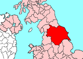
The County of York is by far the largest shire in the United Kingdom. It is divided into three Ridings, whose boundaries meet at the walls of the City of York:
- the East Riding
- the North Riding
- the West Riding
The City of York within the walls is thus the only part of Yorkshire not within one of the three Ridings.
Outside links
This county article is a stub: help to improve Wikishire by building it up.
| Counties of the United Kingdom |
|---|
|
Aberdeen • Anglesey • Angus • Antrim • Argyll • Armagh • Ayr • Banff • Bedford • Berks • Berwick • Brecknock • Buckingham • Bute • Caernarfon • Caithness • Cambridge • Cardigan • Carmarthen • Chester • Clackmannan • Cornwall • Cromarty • Cumberland • Denbigh • Derby • Devon • Dorset • Down • Dumfries • Dunbarton • Durham • East Lothian • Essex • Fermanagh • Fife • Flint • Glamorgan • Gloucester • Hants • Hereford • Hertford • Huntingdon • Inverness • Kent • Kincardine • Kinross • Kirkcudbright • Lanark • Lancaster • Leicester • Lincoln • Londonderry • Merioneth • Middlesex • Midlothian • Monmouth • Montgomery • Moray • Nairn • Norfolk • Northampton • Northumberland • Nottingham • Orkney • Oxford • Peebles • Pembroke • Perth • Radnor • Renfrew • Ross • Roxburgh • Rutland • Selkirk • Shetland • Salop • Somerset • Stafford • Stirling • Suffolk • Surrey • Sussex • Sutherland • Tyrone • Warwick • West Lothian • Westmorland • Wigtown • Wilts • Worcester • York |