Brecknockshire
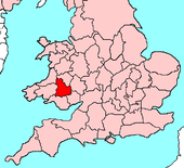
| Brecknockshire Welsh: Sir Frycheiniog United Kingdom | |
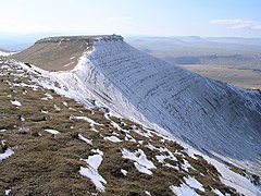
 Pen y Fan | |
|---|---|
| Undeb Hedd Llwyddiant (Unity, peace, prosperity) | |

| |
| [Interactive map] | |
| Area: | 743 square miles |
| Population: | Template:Hcspop |
| County town: | Brecon |
| County flower: | Cuckoo flower [1] |
Brecknockshire or Breconshire is a county in the mountains of Mid-Wales.
Geography
Brecknockshire is an inland county bounded to the north by Radnorshire, to the east by Herefordshire and Monmouthshire, to the south by Monmouthshire and Glamorgan, and to the west by Carmarthenshire and Cardiganshire. The County is predominantly rural and mountainous. The Black Mountains occupy the southeast of the county, the Brecon Beacons the central region, Fforest Fawr the southwest and Mynydd Eppynt the north. Most of the Brecon Beacons National Park lies within the county. The highest point is Pen-y-Fan at 2,907 ft. The River Wye traces nearly the whole of the northern boundary, and the River Usk flows in an easterly direction through the central valley. Of the many waterfalls in the county, Henrhyd Falls are particularly spectacular. The main towns are Brecon, Brynmawr, Builth Wells, Hay-on-Wye, Llanwrtyd Wells and Ystradgynlais. The most important industries are agriculture, forestry and tourism.

Towns and villages
- Brecon (51.947° N -3.391° E)
- Brynmawr (51.796° N -3.183° E)
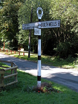
- Builth Wells (52.14° N -3.41° E)
- Hay-on-Wye (52.08° N -3.13° E)
- Llanwrtyd Wells (51.105° N -3.641° E)
- Ystradgynlais (51.781° N -3.751° E)
Transport
Road
The A40 London-West Wales trunk road passes in an east-west direction through the south of the county and the A483 Swansea-Manchester trunk road passes through the north. The A470 Cardiff-Glan Conway trunk road enters the county north of Merthyr Tydfil and after meeting the A40 at Brecon hugs the eastern border until it leaves the county just south of Rhayader.
Rail
The Heart of Wales Line follows a similar route to the A483 through the north of the county, with stops at Sugar Loaf, Llanwrtyd Wells, Llangammarch Wells, and Cilmeri. Builth Road station to the north of Builth Wells is situated in Radnorshire. The south of the county once had an extensive rail network with connections through Glamorgan and Monmouthshire to Neath, Merthyr Tydfil, Cardiff, Newport and thence to the main Great Western main line.
This county article is a stub: help to improve Wikishire by building it up.
| Counties of the United Kingdom |
|---|
|
Aberdeen • Anglesey • Angus • Antrim • Argyll • Armagh • Ayr • Banff • Bedford • Berks • Berwick • Brecknock • Buckingham • Bute • Caernarfon • Caithness • Cambridge • Cardigan • Carmarthen • Chester • Clackmannan • Cornwall • Cromarty • Cumberland • Denbigh • Derby • Devon • Dorset • Down • Dumfries • Dunbarton • Durham • East Lothian • Essex • Fermanagh • Fife • Flint • Glamorgan • Gloucester • Hants • Hereford • Hertford • Huntingdon • Inverness • Kent • Kincardine • Kinross • Kirkcudbright • Lanark • Lancaster • Leicester • Lincoln • Londonderry • Merioneth • Middlesex • Midlothian • Monmouth • Montgomery • Moray • Nairn • Norfolk • Northampton • Northumberland • Nottingham • Orkney • Oxford • Peebles • Pembroke • Perth • Radnor • Renfrew • Ross • Roxburgh • Rutland • Selkirk • Shetland • Salop • Somerset • Stafford • Stirling • Suffolk • Surrey • Sussex • Sutherland • Tyrone • Warwick • West Lothian • Westmorland • Wigtown • Wilts • Worcester • York |