Cromartyshire
| Cromartyshire United Kingdom | |

| |
|---|---|
| [Interactive map] | |
| Area: | 370 square miles |
| Population: | 7,074 |
| County town: | Cromarty |
| Biggest town: | Ullapool |
| County flower: | Spring cinquefoil [1] |
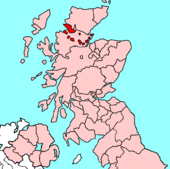
Cromartyshire is a county of the Highlands of Scotland, and certainly the most unusual in form. Cromartyshire consists of a number of physically separated area scattered across Ross from the east to the west coast.
Cromarty stands on the Black Isle on the North Sea coast, while the county's largest town, the fishing village of Ullapool, stands on the Atlantic coast.
This county article is a stub: help to improve Wikishire by building it up.
| Counties of the United Kingdom |
|---|
|
Aberdeen • Anglesey • Angus • Antrim • Argyll • Armagh • Ayr • Banff • Bedford • Berks • Berwick • Brecknock • Buckingham • Bute • Caernarfon • Caithness • Cambridge • Cardigan • Carmarthen • Chester • Clackmannan • Cornwall • Cromarty • Cumberland • Denbigh • Derby • Devon • Dorset • Down • Dumfries • Dunbarton • Durham • East Lothian • Essex • Fermanagh • Fife • Flint • Glamorgan • Gloucester • Hants • Hereford • Hertford • Huntingdon • Inverness • Kent • Kincardine • Kinross • Kirkcudbright • Lanark • Lancaster • Leicester • Lincoln • Londonderry • Merioneth • Middlesex • Midlothian • Monmouth • Montgomery • Moray • Nairn • Norfolk • Northampton • Northumberland • Nottingham • Orkney • Oxford • Peebles • Pembroke • Perth • Radnor • Renfrew • Ross • Roxburgh • Rutland • Selkirk • Shetland • Salop • Somerset • Stafford • Stirling • Suffolk • Surrey • Sussex • Sutherland • Tyrone • Warwick • West Lothian • Westmorland • Wigtown • Wilts • Worcester • York |