Pembrokeshire: Difference between revisions
No edit summary |
No edit summary |
||
| Line 11: | Line 11: | ||
|flower={{countyflower|Pembrokeshire}} | |flower={{countyflower|Pembrokeshire}} | ||
}} | }} | ||
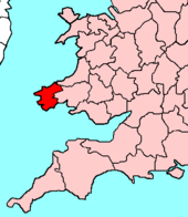
The '''County Palatine of Pembroke''' is a maritime [[Counties of the United Kingdom|shire]] at the south-western tip of [[Wales]]. It is washed by the sea on all sides except in the north where it is bounded by [[Cardiganshire]] and in the east where it is bounded by [[Carmarthenshire]]. | |||
==Geography== | ==Geography== | ||
Revision as of 12:35, 8 October 2010
| Pembrokeshire Welsh: Sir Benfro United Kingdom | |

| |
|---|---|
| Flag | |
| Ex unitate vires (Out of unity is strength) | |

| |
| [Interactive map] | |
| Area: | 655 square miles |
| Population: | Template:Hcspop |
| County town: | Pembroke |
| County flower: | Thrift [1] |
The County Palatine of Pembroke is a maritime shire at the south-western tip of Wales. It is washed by the sea on all sides except in the north where it is bounded by Cardiganshire and in the east where it is bounded by Carmarthenshire.
Geography
The county has a coastline comprising important seabird breeding sites and numerous bays and sandy beaches. Pembrokeshire boasts a predominantly coastal National Park known as the Pembrokeshire Coast National Park, of which includes a 186-mile walking trail known as the Pembrokeshire Coast Path. A large estuary and natural harbour at Milford Haven cuts deeply into the coast, formed by the confluence of the Western Cleddau (which goes through Haverfordwest), the Eastern Cleddau and rivers Cresswell and Carew. The estuary is bridged by the large Cleddau Toll Bridge which carries the A477 between Neyland and Pembroke Dock; upstream bridges are found crossing the Cleddau at Haverfordwest and Canaston.
Large bays are Newport Bay, Fishguard Bay, St Bride's Bay and a portion of Carmarthen Bay. There are several small islands off the Pembrokeshire coast, the largest of which are Ramsey Island, Grassholm Island, Skomer Island and Caldey Island.
In the north of the county are the Preseli Hills, a wide stretch of high moorland with many prehistoric monuments and the source of the bluestones used in the construction of the inner circle of Stonehenge. The highest point of the county is at Foel Cwmcerwyn at 1,759 ft.
Elsewhere the county is relatively flat, most of the land being used for lowland farming of dairy cows, arable crops, oil seed rape, and the well-known Pembrokeshire Potato.
Hundreds
Cities
Towns and villages
- Fishguard
- Haverfordwest
- Milford Haven
- Narberth
- Neyland
- Newport
- Pembroke
- Pembroke Dock
- Saundersfoot
- Tenby
History
Pembrokeshire was founded as a county palatine in 1138 with Gilbert de Clare as the first Earl of Pembroke. It was divided into hundreds in 1536.
This county article is a stub: help to improve Wikishire by building it up.
| Counties of the United Kingdom |
|---|
|
Aberdeen • Anglesey • Angus • Antrim • Argyll • Armagh • Ayr • Banff • Bedford • Berks • Berwick • Brecknock • Buckingham • Bute • Caernarfon • Caithness • Cambridge • Cardigan • Carmarthen • Chester • Clackmannan • Cornwall • Cromarty • Cumberland • Denbigh • Derby • Devon • Dorset • Down • Dumfries • Dunbarton • Durham • East Lothian • Essex • Fermanagh • Fife • Flint • Glamorgan • Gloucester • Hants • Hereford • Hertford • Huntingdon • Inverness • Kent • Kincardine • Kinross • Kirkcudbright • Lanark • Lancaster • Leicester • Lincoln • Londonderry • Merioneth • Middlesex • Midlothian • Monmouth • Montgomery • Moray • Nairn • Norfolk • Northampton • Northumberland • Nottingham • Orkney • Oxford • Peebles • Pembroke • Perth • Radnor • Renfrew • Ross • Roxburgh • Rutland • Selkirk • Shetland • Salop • Somerset • Stafford • Stirling • Suffolk • Surrey • Sussex • Sutherland • Tyrone • Warwick • West Lothian • Westmorland • Wigtown • Wilts • Worcester • York |