Montgomeryshire: Difference between revisions
No edit summary |
No edit summary |
||
| Line 6: | Line 6: | ||
|picture caption= | |picture caption= | ||
|area=780 square miles | |area=780 square miles | ||
|population= | |population={{hcspop|58}} | ||
|county town=[[Montgomery, Montgomeryshire|Montgomery]] | |county town=[[Montgomery, Montgomeryshire|Montgomery]] | ||
|flower={{countyflower|Montgomeryshire}} | |||
}} | }} | ||
'''Montgomeryshire''' is a [[Counties of the United Kingdom|county]] in the heart of the [[Wales|Welsh]] mountains. | |||
==Geography== | |||
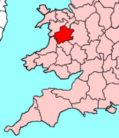
Montgomeryshire is an inland county, bounded to the north by [[Denbighshire]], to the east and south-east by [[Shropshire]], to the south by [[Radnorshire]], to the south-west by [[Cardiganshire]] and to the west and north-west by [[Merionethshire]]. The county is almost wholly mountainous, although there are some fertile valleys on the Shropshire side. The highest point is Mole Sych (2,713 ft). The principal rivers are the Severn and its affluent, the Dovey. Lake Vyrnwy is a reservoir supplying Liverpool. The main industries are agriculture (mainly hill farming) and tourism. | |||
===Towns and villages=== | |||
*[[Llanfyllin]] | |||
*[[Machynlleth]] | |||
*[[Montgomery]] | |||
*[[Newtown]] | |||
*[[Welshpool]] | |||
{{stub}} | {{stub}} | ||
{{British county}} | {{British county}} | ||
Revision as of 12:08, 25 August 2010
| Montgomeryshire Welsh: Sir Faldwyn United Kingdom | |
| Powys paradwys Cymru (Powys paradise of Wales) | |
|---|---|

| |
| [Interactive map] | |
| Area: | 780 square miles |
| Population: | Template:Hcspop |
| County town: | Montgomery |
| County flower: | Spiked speedwell [1] |
Montgomeryshire is a county in the heart of the Welsh mountains.
Geography
Montgomeryshire is an inland county, bounded to the north by Denbighshire, to the east and south-east by Shropshire, to the south by Radnorshire, to the south-west by Cardiganshire and to the west and north-west by Merionethshire. The county is almost wholly mountainous, although there are some fertile valleys on the Shropshire side. The highest point is Mole Sych (2,713 ft). The principal rivers are the Severn and its affluent, the Dovey. Lake Vyrnwy is a reservoir supplying Liverpool. The main industries are agriculture (mainly hill farming) and tourism.
Towns and villages
This county article is a stub: help to improve Wikishire by building it up.
| Counties of the United Kingdom |
|---|
|
Aberdeen • Anglesey • Angus • Antrim • Argyll • Armagh • Ayr • Banff • Bedford • Berks • Berwick • Brecknock • Buckingham • Bute • Caernarfon • Caithness • Cambridge • Cardigan • Carmarthen • Chester • Clackmannan • Cornwall • Cromarty • Cumberland • Denbigh • Derby • Devon • Dorset • Down • Dumfries • Dunbarton • Durham • East Lothian • Essex • Fermanagh • Fife • Flint • Glamorgan • Gloucester • Hants • Hereford • Hertford • Huntingdon • Inverness • Kent • Kincardine • Kinross • Kirkcudbright • Lanark • Lancaster • Leicester • Lincoln • Londonderry • Merioneth • Middlesex • Midlothian • Monmouth • Montgomery • Moray • Nairn • Norfolk • Northampton • Northumberland • Nottingham • Orkney • Oxford • Peebles • Pembroke • Perth • Radnor • Renfrew • Ross • Roxburgh • Rutland • Selkirk • Shetland • Salop • Somerset • Stafford • Stirling • Suffolk • Surrey • Sussex • Sutherland • Tyrone • Warwick • West Lothian • Westmorland • Wigtown • Wilts • Worcester • York |