Oxney: Difference between revisions
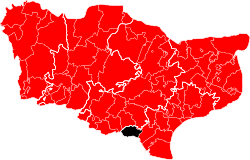
Created page with "{{county|Kent}} thumb|250px|Oxney Hundred, shown within the Lathe of Shepway and Kent '''Oxney''' or the '''Isle of Oxney''' is a hundred..." |
No edit summary |
||
| Line 9: | Line 9: | ||
It comprises the ancient parishes of: | It comprises the ancient parishes of: | ||
*[[Ebony]] (part)<sup>*</sup> | *[[Ebony]] (part)<sup>*</sup> | ||
*[[Stone-in-Oxney]] | *[[Stone-in-Oxney]] (part)<sup>†</sup> | ||
*[[Wittersham]] | *[[Wittersham]] | ||
<sup>*</sup>: Extends into Aloesbridge and Tenterden hundreds. | <sup>*</sup>: Extends into Aloesbridge and Tenterden hundreds.<br /> | ||
<sup>†</sup>: A small area extends into Aloesbridge. | |||
{{Kent hundreds|lathe=Shepway}} | {{Kent hundreds|lathe=Shepway}} | ||
Latest revision as of 09:38, 12 November 2019

Oxney or the Isle of Oxney is a hundred of Kent that forms part of the Lathe of Shepway. It is bounded by Rolvenden in the Lathe of Scray to the west; by Tenterden in the Lathe of Scray to the north; by Blackborne in the Lathe of Scray to the north-east; by Aloesbridge to the east; and by Sussex to the south. It had a population of 1,574 in 2011.
History
In the 13th century, the island was part of the coastline bordering what is now the Romney Marsh. As that silted up, and until the later 17th century, the River Rother which enters the sea beyond Rye and flowed across Kent in a west–east direction, was in a channel to the north of the island. By the late 18th century, the river had changed its course to the south. Today the former sea and river channels are low-lying land, leaving the erstwhile island as high ground, but still retaining its name.
Parishes
It comprises the ancient parishes of:
- Ebony (part)*
- Stone-in-Oxney (part)†
- Wittersham
*: Extends into Aloesbridge and Tenterden hundreds.
†: A small area extends into Aloesbridge.