Irish Sea


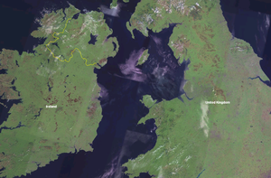
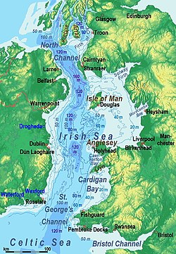
The Irish Sea separates the islands of Ireland and Great Britain. It is connected to the Atlantic Ocean in the north by the North Channel and in the south (at the Celtic Sea) by St George's Channel.
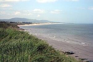
The coasts of the Irish Sea are generally gentle in aspect in contrast to the storm-battered coasts of the open Atlantic. It has few islands relative to the open Atlantic seaboard too: Anglesey is the largest island within the Irish Sea, followed by the Isle of Man.
The sea is of significant economic importance to regional trade, shipping and transport, fishing, and power generation in the form of wind power and nuclear plants. Annual traffic between Great Britain and Ireland amounts to over 12 million passengers and 17 million tons of traded goods.
Extent
The International Hydrographic Organization defines the limits of the Irish Sea (with St George's Channel) as follows:[1]
On the North. The Southern limit of the Scottish Seas [or Inner Seas off the West Coast of Scotland, defined as "a line joining the South extreme of the Mull of Galloway (54°38'N) in Scotland and Ballyquintin Point (54°20'N) in Ireland"]. On the South. A line joining St David's Head (51°54′N 5°19′W) to Carnsore Point (52°10′N 6°22′W).
"Irish Sea" is also the name of one of the BBC's Shipping Forecast areas defined by the coordinates:
Islands
There are few major islands in the Irish Sea; the only two of any great size being Anglesey and the Isle of Man. The most substantial islands in the sea are:
| Island | County | Area (sq mile) | Area (acres) |
|---|---|---|---|
| Anglesey | 276 square miles | 176,640 acres | |
|
The Isle of Man |
221 square miles | 141,440 acres) | |
| Anglesey | 15.22 square miles | 9741 acres | |
| Lancashire | 5 square miles | 3,200 acres | |
| County Dublin | 750 acres | ||
| County Dublin | 53 acres |
Shipping
No tunnel nor bridge crosses the Irish Sea nor its delimiting channels and so the vast majority of heavy goods trade is done by sea. Northern Ireland's ports handle 10 million ton of goods trade with Great Britain annually, while ports in the Republic of Ireland handle 7.6 million ton, representing 50% and 40% respectively of total trade by weight.
The Port of Liverpool handles 32 million tons of cargo and 734 thousand passengers a year.[2] Holyhead port handles most of the passenger traffic from Dublin and Dún Laoghaire ports, as well as 3.3 million tons of freight.[3]
Ports in the Republic handle 3,600,000 travellers crossing the sea each year, amounting to 92% of all Irish Sea travel.[4] This has been steadily dropping for a number of years (20% since 1999), possibly as a result of low cost airlines.
Ferry connections from Great Britain to Ireland across the Irish Sea include the routes between:
- Swansea ↔ Cork
- Fishguard and Pembroke ↔ Rosslare
- Holyhead ↔ Dún Laoghaire
- Holyhead ↔ Dublin
- Birkenhead ↔ Belfast
- Liverpool ↔ Belfast by way of Douglas
- Stranraer ↔ Belfast and Larne
- Cairnryan ↔ Larne
The world's largest car ferry, Ulysses, is operated by Irish Ferries on the Dublin Port–Holyhead route; Stena Line also operates between Britain and Ireland.
The Port of Barrow-in-Furness in Lancashire, despite being one of Britain's largest shipbuilding centres and being home to the United Kingdom's only submarine-building complex, is only a minor port.
There have been various tentative proposals for an Irish Sea Tunnel, for the most part proposing a route across the North Channel between Ulster and Galloway, none of which has progressed to serious consideration.
Historical interest
During First World War the Irish Sea became known as "U-boat Alley", because the U-boats moved their emphasis from the Atlantic to the Irish Sea after the United States entered the war in 1917.[5][6]
Cities and towns
Below is a list of cities and towns around the Irish Sea coasts in order of size:
Environment

Sealife and birdlife
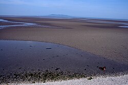
The most accessible and possibly the greatest wildlife resource of the Irish Sea lies in its estuaries: particularly the Dee Estuary, the Mersey Estuary, the Ribble Estuary, Morecambe Bay, the Solway Firth, Loch Ryan, the Firth of Clyde, Belfast Lough, Strangford Lough, Carlingford Lough, Dundalk Bay, Dublin Bay and Wexford Harbour. However, a lot of wildlife also depends on the cliffs, salt marshes and sand dunes of the adjoining shores, the seabed and the open sea itself.
Parts of the bed of the Irish Sea are very rich in wildlife. The seabed southwest of the Isle of Man is particularly noted for its rarities and diversity,[7] as are the horse mussel beds of Strangford Lough. Scallops and queen scallops are found in more gravelly areas. In the estuaries, where the bed is more sandy or muddy, the number of species is smaller but the size of their populations is larger. Brown shrimp, cockles and edible mussels support local fisheries in Morecambe Bay and the Dee Estuary and the estuaries are also important as nurseries for flatfish, herring and sea bass. Muddy seabeds in deeper waters are home to populations of the Dublin Bay prawn, also known as "scampi".[8]
The open sea is a complex habitat in its own right. It exists in three spatial dimensions and also varies over time and tide. For example, where freshwater flows into the Irish Sea in river estuaries its influence can extend far offshore as the freshwater is lighter and "floats" on top of the much larger body of saltwater until wind and temperature changes mix it in. Similarly, warmer water is less dense and seawater warmed in the inter-tidal zone may "float" on the colder offshore water. The amount of light penetrating the seawater also varies with depth and turbidity. This leads to differing populations of plankton in different parts of the sea and varying communities of animals that feed on these populations. However, increasing seasonal storminess leads to greater mixing of water and tends to break down these divisions, which are more apparent when the weather is calm for long periods.
Plankton includes bacteria, plants (phytoplankton) and animals (zooplankton) that drift in the sea. Most are microscopic, but some, such as the various species of jellyfish and Ctenophore|sea gooseberry, can be much bigger.
Diatoms and dinoflagellates dominate the phytoplankton. Although they are microscopic plants, diatoms have hard shells and dinoflagellates have little tails that propel them through the water. Phytoplankton populations in the Irish Sea have a spring "bloom" every April and May, when the seawater is generally at its greenest.
Crustaceans, especially copepods, dominate the zooplankton. However, many animals of the seabed, the open sea and the seashore spend their juvenile stages as part of the zooplankton. The whole plankton "soup" is vitally important, directly or indirectly, as a food source for most species in the Irish Sea, even the largest. The enormous basking shark, for example, lives entirely on plankton and the leatherback turtle's main food is jellyfish.
A colossal diversity of invertebrate species live in the Irish Sea and its surrounding coastline, ranging from flower-like fan-worms to predatory swimming crabs to large chameleon-like cuttlefish.[8] Some of the most significant for other wildlife are the reef-building species like the inshore horse mussel of Strangford Lough, County Down and the inter-tidal honeycomb worm of Morecambe Bay, Lancashire. These build up large structures over many years and, in turn, provide surfaces, nooks and crannies where other marine animals and plants may become established and live out some or all of their lives.
There are quite regular records of live and stranded leatherback turtle in and around the Irish Sea. This species travels north to the waters off the British Isles every year following the swarms of jellyfish that form its prey. Loggerhead turtle, Ridley sea turtle and green turtle are found very occasionally in the Irish Sea but are generally unwell or dead when discovered. They have strayed or been swept out of their natural range further south into colder waters.[9]
The estuaries of the Irish Sea are of international importance for birds. They are vital feeding grounds on bird migration|migration flyways for shorebirds travelling between the Arctic and Africa. Others depend on the milder climate as a refuge when continental Europe is in the grip of winter.[8]
Twenty-one species of seabird are reported as regularly nesting on beaches or cliffs around the Irish Sea. Huge populations of the sea duck, common scoter, spend winters feeding in shallow waters off eastern Ireland, Lancashire and North Wales.[8]
Whales, dolphins and porpoises all frequent the Irish Sea, but knowledge of how many there may be and where they go is somewhat sketchy. About a dozen species have been recorded since 1980, but only three are seen fairly often. These are the harbour porpoise, bottlenose dolphin and common dolphin. The more rarely seen species are minke whale, fin whale, sei whale, sperm whale, northern bottlenose whale, long-finned pilot whale, orca, white-beaked dolphin, striped dolphin and Risso's dolphin.[8]
The common or harbour seal and the grey seal are both resident in the Irish Sea. Common Pinniped|seals breed in Strangford Lough, grey seals in southwest Wales and, in small numbers, on the Isle of Man. Grey seals haul out, but do not breed, off Hilbre Island and the Wirral peninsula, Cheshire and Walney Island and Barrow-in-Furness, Lancashire.

Proposed tunnel projects
Discussions of linking Britain to Ireland began in 1895,[10] with an application for £15,000 towards the cost of carrying out borings and soundings in the North Channel to see if a tunnel between Ireland and Scotland were viable. Sixty years later Harford Montgomery Hyde, Unionist MP for North Belfast, called for the building of such a tunnel.[11] A tunnel project has been discussed several times in the Irish parliament.[12][13][14][15]
The idea for such a 21 mile-long rail bridge or tunnel, continues to be mooted.[16]
Several potential Irish Sea tunnel projects have been proposed, most recently the "Tusker Tunnel" between the ports of Rosslare and Fishguard proposed by The Institute of Engineers of Ireland in 2004.[17][18] A different proposed route between Dublin and Holyhead was proposed in 1997 by the British engineering firm Symonds. Either tunnel, at 50 miles, would be by far the longest in the world, and would cost an estimated €20 billion.
Outside links
- Fylde Coast Marine Life Project
- Irish Sea Conservation Zones
- The Wildlife Trusts Living Seas - Irish Sea
References
- ↑ "Limits of Oceans and Seas, 3rd edition + corrections". International Hydrographic Organization. 1971. p. 42 [corrections to page 12]. http://www.iho-ohi.net/iho_pubs/standard/S-23/S23_1953.pdf. Retrieved 6 February 2010.
- ↑ Port Statistics, (Link), Mersey Docks Website
- ↑ UK Port Traffic Highlights: 2002, (pdf), UK Maritime Statistics, Dept of Transport
- ↑ Direct Passenger Movement by Sea from and to Ireland (Republic), (link), Central Statistics Office of Ireland
- ↑ U-Boat Alley by Roy Stokes, published by Compuwreck, ISBN 0-9549186-0-6
- ↑ The War in Maps: The Irish Sea, (Link), UBoat.net
- ↑ Barne, J.H., Robson, C.F., Kaznowska, S.S., Doody, J.P., & Davidson, N.C., eds. 1996. Coasts and seas of the United Kingdom. Region 13 Northern Irish Sea: Colwyn Bay to Stranraer, including the Isle of Man. Peterborough, Joint Nature Conservation Committee, ISBN 1 873701 87 X
- ↑ 8.0 8.1 8.2 8.3 8.4 Irish Sea Study Group Report, Part 1, NATURE CONSERVATION, Liverpool University Press, 1990 ISBN 0 85323 227 X
- ↑ Irish Sea Leatherback Turtle Project - aiming to understand the populations, origins and behaviour of leatherback turtles in the Irish Sea
- ↑ "TUNNEL UNDER THE SEA", The Washington Post, May 2, 1897
- ↑ "An Irishman's Diary" by Wesley Boyd, (Link), The Irish Times, Feb 2004 (subscription required)
- ↑ Written Answers. - Sea Transport, (Link), Dáil Éireann - Volume 384 - 16 November 1988
- ↑ Written Answers. - Irish Sea Railway Ferry, (Link), Dáil Éireann - Volume 434 - 19 October 1993
- ↑ Written Answers. - Ireland-UK Tunnel, (Link), Dáil Éireann - Volume 517 - 29 March 2000
- ↑ Written Answers - Transport Projects, (Link), Dáil Éireann - Volume 597 - 15 February 2005
- ↑ Bridge to Northern Ireland mooted, BBC News Scotland, 22 August 2007
- ↑ A Vision of Transport in Ireland in 2050, IEI report (pdf), The Irish Academy of Engineers, 21/12/2004
- ↑ "Tunnel 'vision' under Irish Sea". BBC News. December 23, 2004. http://news.bbc.co.uk/1/hi/wales/south_west/4121001.stm.