Strafforth and Tickhill: Difference between revisions
Created page with "'''Strafforth and Tickhill''' is a wapentake in the West Riding of Yorkshire, adjacent to the borders with Derbyshire, Nottinghamshire..." |
No edit summary |
||
| (4 intermediate revisions by the same user not shown) | |||
| Line 1: | Line 1: | ||
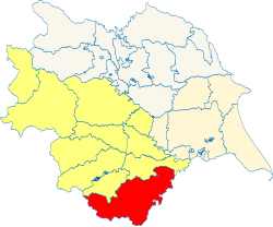
'''Strafforth and Tickhill''' is a wapentake in the [[West Riding of Yorkshire|West Riding]] of [[Yorkshire]], adjacent to the borders with [[Derbyshire]], [[Nottinghamshire]] and [[Lincolnshire]]. It is bordered by [[Staincross]] to the north-west; and by [[Osgoldcross]] to the north-east. To the east is Lincolnshire; to the south-east, Nottinghamshire; and to the south-west lies Derbyshire. It had a population of 1,037,564 in 2011, increasing to 1,038,119 if detached parts are disregarded. | [[File:Strafforth and Tickhill Wapentake - Yorkshire.svg|thumb|250px|Strafforth and Tickhill Wapentake shown within the West Riding and Yorkshire]] | ||
'''Strafforth and Tickhill''' is a wapentake in the [[West Riding of Yorkshire|West Riding]] of [[Yorkshire]], adjacent to the borders with [[Derbyshire]], [[Nottinghamshire]] and [[Lincolnshire]]. It is bordered by [[Staincross Wapentake|Staincross]] to the north-west; and by [[Osgoldcross]] to the north-east. To the east is Lincolnshire; to the south-east, Nottinghamshire; and to the south-west lies Derbyshire. It had a population of 1,037,564 in 2011, increasing to 1,038,119 if detached parts are disregarded. | |||
It comprises the ancient parishes of: | It comprises the ancient parishes of: | ||
| Line 14: | Line 15: | ||
*[[Bolton upon Dearne]] | *[[Bolton upon Dearne]] | ||
*[[Brodsworth]] | *[[Brodsworth]] | ||
*[[Cantley]] | *[[Cantley, Yorkshire|Cantley]] | ||
*[[Clayton with Frickley]] | *[[Clayton with Frickley]] | ||
*[[Conisbrough]] | *[[Conisbrough]] | ||
| Line 36: | Line 37: | ||
*[[Loversall]] | *[[Loversall]] | ||
*[[Maltby]] | *[[Maltby]] | ||
*[[Marr]] | *[[Marr, Yorkshire|Marr]] | ||
*[[Mexborough]] | *[[Mexborough]] | ||
*[[Ravenfield]] | *[[Ravenfield]] | ||
| Line 48: | Line 49: | ||
*[[Thorpe Salvin]] | *[[Thorpe Salvin]] | ||
*[[Tickhill]] | *[[Tickhill]] | ||
*[[Thrybergh]] | *[[Thrybergh]] | ||
*[[Thurnscoe]] | *[[Thurnscoe]] | ||
| Line 57: | Line 57: | ||
*[[Warmsworth]] | *[[Warmsworth]] | ||
*[[Wath upon Dearne]] | *[[Wath upon Dearne]] | ||
*[[Whiston]] | *[[Whiston, Yorkshire|Whiston]] | ||
*[[Wickersley]] | *[[Wickersley]] | ||
{{div col end}} | {{div col end}} | ||
| Line 64: | Line 64: | ||
<sup>‡</sup>: Remainder in Osgoldcross. | <sup>‡</sup>: Remainder in Osgoldcross. | ||
{{Yorkshire wapentakes}} | {{Yorkshire wapentakes|riding=West}} | ||
Latest revision as of 20:39, 6 November 2023

Strafforth and Tickhill is a wapentake in the West Riding of Yorkshire, adjacent to the borders with Derbyshire, Nottinghamshire and Lincolnshire. It is bordered by Staincross to the north-west; and by Osgoldcross to the north-east. To the east is Lincolnshire; to the south-east, Nottinghamshire; and to the south-west lies Derbyshire. It had a population of 1,037,564 in 2011, increasing to 1,038,119 if detached parts are disregarded.
It comprises the ancient parishes of:
- Adwick le Street
- Armthorpe
- Anston cum Membris
- Aston with Aughton
- Barnby Dun
- Bentley with Arksey
- Barnburgh
- Blyth (Austerfield and Bawtry)*
- Braithwell
- Bolton upon Dearne
- Brodsworth
- Cantley
- Clayton with Frickley
- Conisbrough
- Darfield (except Ardsley and Worsborough)†
- Dinnington
- Doncaster
- Ecclesfield
- Edlington
- Finningley (Baxton and Auckley, part)*
- Firbeck
- Fishlake
- Handsworth
- Harthill
- Hatfield
- Hickleton
- High Melton
- Hooton Pagnell
- Hooton Roberts
- Kirk Sandall
- Laughton en le Morthen
- Loversall
- Maltby
- Marr
- Mexborough
- Ravenfield
- Rawmarsh
- Rossington
- Rotherham
- Sheffield
- South Kirkby (Hamphall Stubs)‡
- Sprotbrough
- Stotfold (ex. par.)
- Thorpe Salvin
- Tickhill
- Thrybergh
- Thurnscoe
- Treeton
- Wadworth
- Wales
- Wallingwells (ex. par., part)*
- Warmsworth
- Wath upon Dearne
- Whiston
- Wickersley
*: Remainder in Nottinghamshire.
†: In Staincross.
‡: Remainder in Osgoldcross.
|
East Riding: Buckrose • Dickering • Harthill • Holderness • Howdenshire • Ouse and Derwent • North Riding: Allertonshire • Birdforth • Bulmer • East Gilling • Hallikeld • Hang East • Hang West • Langbaurgh • Pickering Lythe • Ryedale • West Gilling • Whitby Strand • West Riding: Agbrigg and Morley (Agbrigg, Morley) • Ainsty • Barkston Ash • Claro • Osgoldcross • Skyrack • Staincliffe and Ewcross (Staincliffe, Ewcross) • Staincross • Strafforth and Tickhill |
