Difference between revisions of "Annandale Way"
(→The Borders Forest Trust Corehead project) |
(→Lochmaben and its vendace) |
||
| Line 28: | Line 28: | ||
===Lochmaben and its vendace === | ===Lochmaben and its vendace === | ||
| − | Along the path by [[Castle Loch]] in Lochmaben there is a sculpture trail. | + | Along the path by [[Castle Loch, Dumfriesshire|Castle Loch]] in Lochmaben there is a sculpture trail. |
One sculptured seat back bears the likeness of a fish and the name ‘Vendace’: it refers to the vendace, a fish locally extinct but which was once found in abundance in the Lochmaben lochs.<ref>[http://vendace.co.uk/ Vendace.co.uk] – British locations for finding the vendace]</ref><ref> | One sculptured seat back bears the likeness of a fish and the name ‘Vendace’: it refers to the vendace, a fish locally extinct but which was once found in abundance in the Lochmaben lochs.<ref>[http://vendace.co.uk/ Vendace.co.uk] – British locations for finding the vendace]</ref><ref> | ||
Latest revision as of 22:43, 21 March 2017


The Annandale Way is a 53-mile hiking trail in Dumfriesshire, following Annandale, the valley of the River Annan, from its source in the Moffat Hills to the sea in the Solway Firth south of the town of Annan.
The route, which was established on 12 September 2009, has been designed to be traversable in four to five days as a continuous walk but it also offers several fine day-walks. Overnight stops can be arranged in small market towns and villages along the route such as Moffat, Johnstonebridge, Lochmaben, Lockerbie, or Annan. The route has been developed in co-operation with local communities, with the support of local estates and farmers, to help promote Annandale as a new area for walking. Its trailheads are near the Devil's Beef Tub in the Moffat Hills and on the Solway Firth just south of Annan.
Contents
Route description
The northernmost point of the walk is marked by a commemorative cairn at the head of the Tweedhope Burn in the saddle between Spout Craig and Chalk Ridge Edge (NT084138). This is also on the watershed between the headwater systems of the River Annan to the south and the River Tweed to the north. This cairn is seen at the start of the route, although it is a fair way from a road, so the walk has begun before the start.
This northernmost section of the Way, from Moffat up Annandale to the cairn, offers a loop such that one can get to the cairn from the east bank of the River Annan by the Tweedhope burn and then return by a circumnavigation of the Devil's Beef Tub to Annanhead and the west bank of the river. On the official website this loop out from Moffat and back is suggested as a 13-mile one-day walk.
Heading south from Moffat the Annandale Way joins the Southern Upland Way briefly near the village of Beattock, beyond which it passes through ancient oak forests and over farmland down the valley to near Templand, where again there is a choice of alternative routes.
The choice from there is either to go by Millhousebridge and Kettleholm to Hoddom Castle with a possible loop off to Lockerbie, or to go by Lochmaben and Hightae to Hoddom Castle. The Lockerbie route takes in Lockerbie Wildlife Trust's[1] Eskrigg Nature Reserve with its loch and wildlife while the Lochmaben route takes in Castle Loch with its ruined mediæval castle.
Between Moffat and Hoddom Castle the Way does not stay close to the river Annan, although it does cross it once on each of the two alternative routes. From Hoddom Castle, however, the Way follows the river most of the time as it makes its way southward by Brydekirk, Annan and Newbie to the Solway at Barnkirk Point.
Some features to look out for along the route
The Borders Forest Trust Corehead project
When gaining access to the cairn at the northern end of the Annandale Way by approaching it along the valley floor northward from Moffat, the route starts to ascend eastward just before it arrives at Corehead. It ascends by the Tweedhope Burn from the valley to the starting cairn near Spout Craig. The route as you ascend is filled with trees planted by the Borders Forest Trust[2] since they took over ownership of 1,581 acres of land at Corehead in the summer of 2009. Their mission statement reads, "The hills and valleys of Corehead were once covered in the native woodland and wild habitats of the Ettrick Forest. Due to centuries of intensive grazing the land is now bare and only small pockets of heather moorland and native woodland remain. The Trust plans to return these lost habitats to the land of Corehead and restore a core area of the wild Ettrick Forest to the south of Scotland."
Iron Age settlements in Upper Annandale
Upper Annandale is rich in Iron Age settlements, whose remain are not always easy to find with the untrained eye. However, on Iron Age village site at NT067104, on the descent along the old coach road from the A701 heading for Moffat, is very close to the Annandale Way and reasonably easy to make out.
Hugh Dowding Monument
The Annandale Way does not actually go through Moffat but no great diversion is require to do so. In the park at the southern end of town there is a memorial to Air Chief Marshal Hugh Dowding who was born in the town in 1882. He was the commander of RAF Fighter Command during the Battle of Britain, and is generally credited with playing a crucial role in Britain's defence, and hence, the defeat of Hitler's plan to invade Britain.
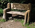
Lochmaben and its vendace
Along the path by Castle Loch in Lochmaben there is a sculpture trail.
One sculptured seat back bears the likeness of a fish and the name ‘Vendace’: it refers to the vendace, a fish locally extinct but which was once found in abundance in the Lochmaben lochs.[3][4][5] carved into the wood above the fish.
There remains a thriving population of vendace in Loch Skeen[6] in the Moffat Hills close by, having been introduced as fry from Bassenthwaite Lake in Cumberland, in 1997 and 1999, since when the Bassenthwaite vendace population has vanished.
Mossburn Community Animal Farm
After passing through the village of Hightae the Annandale Way travels south briefly along the B7020 before it turns off at Mossburn Community Animal Farm.[7] This establishment was originally set up in 1987 to provide help for misused, abused, unwanted and neglected horses and ponies as well as to offer help for young people with physical and mental problems. This original remit was later widened into care for all domestic animals except cats, dogs and donkeys which have their own specific charities.
Rammerscales to Burnswark
From the animal refuge the track begins to climb up onto the ridge above Rammerscales House[8] (which dates from 1768 and has an interesting history). Travelling south along this ridge presents excellent views of both Annandale in general and of the distinctive flat top of Burnswark,[9] a hill which dominates the low land to the east of Annandale. There was a hill fort of the ancient Britons at Burnswark until it was taken over by the Romans who built large marching camps on both the north and south sides of the hill and went on to turn the south side into a training camp. Burnswark is one suggested location for the Battle of Brunanburh, named Brunanweorc in one source.
The ridge has small hills rising from it on which there are two castle forts: Range Castle Fort and the less obvious Moss Castle Fort.[10] Just beyond these on the top of Almagill hill is a steep pyramidal monument 20 feet high to the huntsman called Joe Graham.[11] The inscription on this monument reads, "In Memory of Joe Graham for many years huntsman of the Dumfries Shire fox hounds who died in 1893 at the age of 80 and now he has gone far far away we shall never hear his voice in the morning".
Standing beside the trig point on the highest point of the ridge, at a height of 712 feet above sea level, the monument presents an impressive prospect.
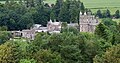
Hoddom Castle and Repentance Tower
There is a caravan park with camping facilities[12] at Hoddom Castle which could be useful for those intending to walk the Annandale Way. Repentance Tower perched on top of a hill with a view over the Solway Firth served as a watch tower for Hoddom Castle and a fire lit on the top would have served to warn the neighbourhood of invasion. It was built around 1560 and has a rich history in legend and local hearsay. Many stories attempt to explain its construction but all conclude that the word "Repentance" which is inscribed above the door suggests that the tower was built to make amends for some act of treachery.[13] There is certainly a bleak enigmatic presence about the place.
Voice of the river
Along the Annandale Way at various points there is a series of information boards each with the title "Voice of the River" which address the reader as though it were the river speaking and telling of the flora and fauna, the history of each place and generally what is to be seen around the river at that point. There are also other boards more specifically dedicated to the wildlife and ecology. One natural feature of the river bank between Annan and Brydekirk is the proliferation of Himalayan balsam; a pretty, orchid-like flower with a deadly catch that it is rapaciously colonising the river bank to the exclusion of all else.
Historical connections
The Norman Brus family, from which Robert the Bruce (King Robert I) arose, was granted land in Annandale by King David I. The motte of their first castle is still visible and the lower protective bailey, close by the Annandale Way. A stone known as the Bruce Stone lies in Annan town hall;[14] it dates from around 1300 and has inscribed on it "Robert de Brus Count of Carrick and Lord of Annandale".
Hightae, Greenhill, Heck and Smallholm were founded as royal towns by King Robert I in the early 14th century, with land entrusted to experienced soldiers.
South of Lochmaben Castle are the earthworks and stonework from a castle built at various times by Scottish and English lords and kings and exchanged between them during the bloodletting of the Middle Ages.
In 1685 the Covenanter John Hunter fled to he Devil’s beef Tub to hide, but was shot on the hillside, and is today commemorated by the trail.
There was a peel tower at Corehead owned by a Thomas Halliday[15] in 1297. it is claimed that this Thomas Halliday was married to one of the daughters of Sir Malcolm Wallace and was thus a brother-in-law of Sir William Wallace.
Pictures

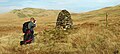
The cairn at the north end of the Annandale Way
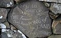
Stone set into cairn at north end of Annandale Way
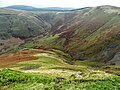
The Devil's Beef Tub and Annanhead Hill above
Sculpted seat by Castle Loch Lochmaben
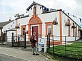
The Royal Four Towns Hall in Hightae
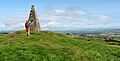
The Joe Graham monument on Almagill Hill
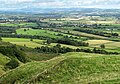
Near the monument: Lochmaben (L), Hightae (M), Lockerbie (R) and the Ettrick Hills beyond
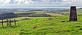
From Almagill Hill to the Solway and the Lake District beyond
Hoddom Castle from the Repentance Tower
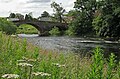
Downriver to the bridge at Brydekirk
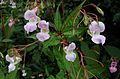
Himalayan balsam beside the river


Outside links
References
- ↑ Lockerbie Wildlife Trust
- ↑ Website of Borders Forest Trust.
- ↑ Vendace.co.uk – British locations for finding the vendace]
- ↑ ''Ancient vendace fish saved from the edge of extinction' - The Daily Telegraph
- ↑ ARKive website with extensive scientific information about the vendace and many links to further information
- ↑ View of Loch Skeen with information about the survival of vendace there and their probable demise in Lochmaben.
- ↑ Mossburn Community Animal Farm
- ↑ Rammerscales House.
- ↑ Roman Britain: Burnswark
- ↑ Moss Castle Fort
- ↑ Joe Graham monument - British Listed Buildings
- ↑ Website for Hoddom Castle Caravan Park.
- ↑ Information about Repentance Tower and pictures of it.
- ↑ Annan Town Hall: The Brus Stane
- ↑ History of the Halliday family