Difference between revisions of "Bulmer Wapentake"
| Line 6: | Line 6: | ||
It comprises the ancient parishes of: | It comprises the ancient parishes of: | ||
{{div col|3}} | {{div col|3}} | ||
| − | *[[Aldborough]] ([[Ellenthorpe]]; Lower Dunsforth, part; and Upper Dunsforth with Branton, part)<sup>*</sup> | + | *[[Aldborough, Yorkshire|Aldborough]] ([[Ellenthorpe]]; [[Lower Dunsforth]], part; and [[Upper Dunsforth]] with Branton, part)<sup>*</sup> |
*[[Alne]] | *[[Alne]] | ||
*[[Barton-le-Street]] (Coneysthorpe)<sup>†</sup> | *[[Barton-le-Street]] (Coneysthorpe)<sup>†</sup> | ||
Revision as of 18:10, 31 August 2021
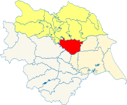
Bulmer is a wapentake of the North Riding of Yorkshire. It is bounded by Hallikeld, Birdforth and Ryedale to the north; by Buckrose in the East Riding to the east; by Ouse and Derwent in the East Riding to the south-east; by the city of York within the walls to the south; by the Ainsty in the West Riding to the south-west; by Claro in the West Riding to the west.
Including those suburbs of York in the North Riding, it had a population of 113,232 in 2011, increasing to 113,640 if Crayke is included.
It comprises the ancient parishes of:
- Aldborough (Ellenthorpe; Lower Dunsforth, part; and Upper Dunsforth with Branton, part)*
- Alne
- Barton-le-Street (Coneysthorpe)†
- Bossall
- Brandsby
- Brafferton
- Bulmer
- Carrs (ex. par.)
- Crambe
- Dalby
- Easingwold
- Gate Helmsley
- Foston
- Haxby
- Hardy Flatts (ex. par.)
- Holtby
- Hovingham (Scackleton)†
- Huntington
- Huttons Ambo
- Marton in the Forest
- Myton upon Swale
- Newton upon Ouse
- Osbaldwick
- Overton
- Sheriff Hutton
- Side Ings (ex. par.)
- Skelton
- Stillington
- Stockton on the Forest
- Strensall
- Sutton on the Forest
- Terrington
- Thormanby
- Upper Helmsley
- Warthill
- Whenby
- Wigginton
*: Remainder in Claro (W. R.)
†: Remainder in Ryedale.
Additionally Crayke forms a detached part of County Durham, locally situate in Bulmer wapentake.
| |
|---|
|
East Riding: Buckrose • Dickering • Harthill • Holderness • Howdenshire • Ouse and Derwent • North Riding: Allertonshire • Birdforth • Bulmer • East Gilling • Hallikeld • Hang East • Hang West • Langbaurgh • Pickering Lythe • Ryedale • West Gilling • Whitby Strand • West Riding: Agbrigg and Morley (Agbrigg, Morley) • Ainsty • Barkston Ash • Claro • Osgoldcross • Skyrack • Staincliffe and Ewcross (Staincliffe, Ewcross) • Staincross • Strafforth and Tickhill |
