Heart of England Way: Difference between revisions
Created page with "right|thumb|350px|The Heart of Englandf Way in Cannock Chase {{county|Warwickshire}} The '''Heart of England Way''' is a long distance walk of ..." |
No edit summary |
||
| (2 intermediate revisions by the same user not shown) | |||
| Line 1: | Line 1: | ||
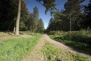
[[File:Cannock Chase Path.jpg|right|thumb|350px|The Heart of | [[File:Cannock Chase Path.jpg|right|thumb|350px|The Heart of England Way in Cannock Chase]] | ||
{{county|Warwickshire}} | {{county|Warwickshire}} | ||
The '''Heart of England Way''' is a long distance walk of 101 miles through the [[Midlands]]. North to south, the walk starts from [[Milford, Staffordshire|Milford Common]] on [[Cannock Chase]] and ends at [[Bourton-on-the-Water]] in [[Gloucestershire]], in the [[Cotswolds]]. On its route the Way passes through three [[Counties of the United Kingdom|counties]]; [[Staffordshire]], [[Warwickshire]] and [[Gloucestershire]]. | The '''Heart of England Way''' is a long-distance walk of 101 miles through the [[Midlands]]. North to south, the walk starts from [[Milford, Staffordshire|Milford Common]] on [[Cannock Chase]] and ends at [[Bourton-on-the-Water]] in [[Gloucestershire]], in the [[Cotswolds]]. On its route the Way passes through three [[Counties of the United Kingdom|counties]]; [[Staffordshire]], [[Warwickshire]] and [[Gloucestershire]]. | ||
The route explores the countryside of the Midlands rather than its industrial towns. From the midst of Staffordshire it runs generally towards the | The route explores the countryside of the Midlands rather than its industrial towns. From the midst of Staffordshire it runs generally towards the south-east, passing north of the [[Black Country]] and [[Birmingham]], and turning south between the latter city and [[Coventry]], and continuing southwards through the western side of Warwickshire into the north of Gloucestershire to the Cotswolds. | ||
The walk provides links to a number of other long distance walks: the [[Beacon Way]], the [[Staffordshire Way]], the [[Two Saints Way]], the [[Arden Way]], the [[Cotswold Way]], the [[Oxfordshire Way]], and the [[Thames Path]]. It is maintained by the Heart of England Way Association. | The walk provides links to a number of other long distance walks: the [[Beacon Way]], the [[Staffordshire Way]], the [[Two Saints Way]], the [[Arden Way]], the [[Cotswold Way]], the [[Oxfordshire Way]], and the [[Thames Path]]. It is maintained by the Heart of England Way Association. | ||
| Line 15: | Line 15: | ||
{| | {| | ||
|- | |- | ||
|'''Staffordshire:''' | |valign="top"|'''Staffordshire:''' | ||
*[[Milford, Staffordshire|Milford]] | *[[Milford, Staffordshire|Milford]] | ||
*[[Cannock Chase]] | *[[Cannock Chase]] | ||
*[[Castle Ring]] | *[[Castle Ring]] | ||
*[[Lichfield]] | *[[Lichfield]] | ||
*[[Drayton Bassett]] | *[[Drayton Bassett]] | ||
|valign="top"|'''Warwickshire:''' | |||
*[[Shustoke]] | *[[Shustoke]] | ||
*[[Meriden]] | *[[Meriden, Warwickshire|Meriden]] | ||
*[[Berkswell]] | *[[Berkswell]] | ||
*[[Balsall Common]] | *[[Balsall Common]] | ||
| Line 30: | Line 30: | ||
*[[Alcester]] | *[[Alcester]] | ||
*[[Bidford-on-Avon]] | *[[Bidford-on-Avon]] | ||
|'''Gloucestershire:''' | |valign="top"|'''Gloucestershire:''' | ||
*[[Upper Quinton]] | *[[Upper Quinton]] | ||
*[[Mickleton, Gloucestershire|Mickleton]] | *[[Mickleton, Gloucestershire|Mickleton]] | ||
| Line 53: | Line 53: | ||
*[http://www.ramblers.org.uk/INFO/paths/heartofengland.html The Rambler's Association info on the Heart of England Way] | *[http://www.ramblers.org.uk/INFO/paths/heartofengland.html The Rambler's Association info on the Heart of England Way] | ||
*[http://www.geograph.org.uk/search.php?i=3817905 Photos taken along the Heart of England Way on ''geograph.org.uk''] | *[http://www.geograph.org.uk/search.php?i=3817905 Photos taken along the Heart of England Way on ''geograph.org.uk''] | ||
{{UK Trails}} | {{UK Trails}} | ||
Latest revision as of 10:07, 1 December 2016

The Heart of England Way is a long-distance walk of 101 miles through the Midlands. North to south, the walk starts from Milford Common on Cannock Chase and ends at Bourton-on-the-Water in Gloucestershire, in the Cotswolds. On its route the Way passes through three counties; Staffordshire, Warwickshire and Gloucestershire.
The route explores the countryside of the Midlands rather than its industrial towns. From the midst of Staffordshire it runs generally towards the south-east, passing north of the Black Country and Birmingham, and turning south between the latter city and Coventry, and continuing southwards through the western side of Warwickshire into the north of Gloucestershire to the Cotswolds.
The walk provides links to a number of other long distance walks: the Beacon Way, the Staffordshire Way, the Two Saints Way, the Arden Way, the Cotswold Way, the Oxfordshire Way, and the Thames Path. It is maintained by the Heart of England Way Association.
Records
On 20 July 2013, Ultra Runner David Hollyoak set a solo course record of completing the entire length of the Heart of England Way (south to north) non-stop in 25 hours 11 minutes. The run is corroborated by having a relay of runners to run sections with him all the way. GPS statistics showed the route to be 105 miles.
Places on the way
On the way, the route passes, north to south, through the following places amongst others:
| Staffordshire: | Warwickshire: | Gloucestershire: |
Pictures
-
Katyn Memorial on Cannock Chase
-
Cannock Chase
-
Castle Ring
-
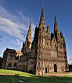
Lichfield Cathedral
-
Kingsbury Water Park
-
Bourton on the Water
Outside links
- The Heart of England Way
- The Heart of England Way - The Long-Distance Walkers' Association
- The Rambler's Association info on the Heart of England Way
- Photos taken along the Heart of England Way on geograph.org.uk


