Buttermere: Difference between revisions
Created page with 'right|thumb|350px|Buttermere, with Fleetwith Pike behind right|thumb|200px|Map of Buttermere {{#vardefine:sh…' |
m clean up, typos fixed: an 11th century → an 11th-century |
||
| (3 intermediate revisions by one other user not shown) | |||
| Line 5: | Line 5: | ||
==Geography== | ==Geography== | ||
The lake is a mile and a quarter long by a quarter of a mile wide, and is 75 feet deep at its maximum.<ref name="Waterscape">{{cite web|url=http://www.waterscape.com/canals-and-rivers/buttermere |title=Waterscape - Buttermere|publisher=Waterscape}}</ref> It has an elevation above sea level of | The lake is a mile and a quarter long by a quarter of a mile wide, and is 75 feet deep at its maximum.<ref name="Waterscape">{{cite web|url=http://www.waterscape.com/canals-and-rivers/buttermere |title=Waterscape - Buttermere|publisher=Waterscape}}</ref> It has an elevation above sea level of 329 feet. A place of considerable scenic value, it is situated towards the head of the valley of the [[River Cocker, Cumberland|River Cocker]] and is surrounded by fells, notably the [[High Stile]] range to the south west, [[Robinson]] to the north east, [[Fleetwith Pike]] and [[Haystacks]] to the south east and [[Grasmoor]] to the northwest. | ||
The village of Buttermere stands at the north western end of the lake, and beyond this is Buttermere's twin, [[Crummock Water]]. There is a path around the lake which is about 4½ miles long, and at one point runs through a rock tunnel beneath the locality of Hasness. | The village of Buttermere stands at the north western end of the lake, and beyond this is Buttermere's twin, [[Crummock Water]]. There is a path around the lake which is about 4½ miles long, and at one point runs through a rock tunnel beneath the locality of Hasness. | ||
| Line 14: | Line 14: | ||
There are two possible origins for the name "Buttermere". One suggests that it idicates a lake by the dairy pastures, from the Old English "butere mere" (literally "butter mere"). | There are two possible origins for the name "Buttermere". One suggests that it idicates a lake by the dairy pastures, from the Old English "butere mere" (literally "butter mere"). | ||
Another theory has it that its name is corrupted from a personal name: Robert Ferguson asserts in his 1866 work, ''"The Northmen in Cumberland and Westmoreland"'' that Buttermere derives from the Old Norse personal name "Buþar", as in "Buthar's mere", which accords with local tradition which says that the valley of Buttermere was part of the holdings of an 11th century Norse chieftain called "Buthar" (sometimes spelt "Boethar").<ref>[http://www.english-lakes.com/buttermere.html Buttermere] - English Lakes.com</ref> "Mere" is an English affix though. | Another theory has it that its name is corrupted from a personal name: Robert Ferguson asserts in his 1866 work, ''"The Northmen in Cumberland and Westmoreland"'' that Buttermere derives from the Old Norse personal name "Buþar", as in "Buthar's mere", which accords with local tradition which says that the valley of Buttermere was part of the holdings of an 11th-century Norse chieftain called "Buthar" (sometimes spelt "Boethar").<ref>[http://www.english-lakes.com/buttermere.html Buttermere] - English Lakes.com</ref> "Mere" is an English affix though. | ||
==Historical interest== | ==Historical interest== | ||
| Line 28: | Line 28: | ||
==Outside links== | ==Outside links== | ||
{{commons | {{commons}} | ||
*Map: {{wmap|54.533|-3.267}} | |||
*[http://www.nationaltrust.org.uk/buttermere-and-ennerdale/ Buttermere and Ennerdale information at the National Trust.] | *[http://www.nationaltrust.org.uk/buttermere-and-ennerdale/ Buttermere and Ennerdale information at the National Trust.] | ||
*[http://www.english-lakes.com/buttermere.html Buttermere Illustrated Guide to the Lake District] | *[http://www.english-lakes.com/buttermere.html Buttermere Illustrated Guide to the Lake District] | ||
| Line 38: | Line 39: | ||
{{Reflist}} | {{Reflist}} | ||
{{Lake District lakes}} | {{Lake District lakes}} | ||
[[Category:Lakes of Cumberland]] | [[Category:Lakes of Cumberland]] | ||
[[Category:National Trust properties in Cumberland]] | |||
Latest revision as of 17:42, 1 February 2016


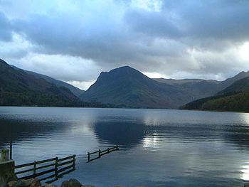
Buttermere is a lake in Cumberland, one of the famous waters of the Lake District. The adjacent village of Buttermere takes its name from the lake. It is owned by the National Trust, forming part of their Buttermere and Ennerdale property.
Geography
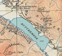
The lake is a mile and a quarter long by a quarter of a mile wide, and is 75 feet deep at its maximum.[1] It has an elevation above sea level of 329 feet. A place of considerable scenic value, it is situated towards the head of the valley of the River Cocker and is surrounded by fells, notably the High Stile range to the south west, Robinson to the north east, Fleetwith Pike and Haystacks to the south east and Grasmoor to the northwest.
The village of Buttermere stands at the north western end of the lake, and beyond this is Buttermere's twin, Crummock Water. There is a path around the lake which is about 4½ miles long, and at one point runs through a rock tunnel beneath the locality of Hasness.
Access is by road, from Cockermouth in the north west; from Borrowdale by way of the Honister Pass; or from Braithwaite and the Newlands Valley by way of Newlands Hause.
Name
There are two possible origins for the name "Buttermere". One suggests that it idicates a lake by the dairy pastures, from the Old English "butere mere" (literally "butter mere").
Another theory has it that its name is corrupted from a personal name: Robert Ferguson asserts in his 1866 work, "The Northmen in Cumberland and Westmoreland" that Buttermere derives from the Old Norse personal name "Buþar", as in "Buthar's mere", which accords with local tradition which says that the valley of Buttermere was part of the holdings of an 11th-century Norse chieftain called "Buthar" (sometimes spelt "Boethar").[2] "Mere" is an English affix though.
Historical interest
From his hidden stronghold at Buttermere, local legend has it, Jarl Buthar conducted a campaign of running resistance against the Norman invaders, from the time of William the Conqueror's Harrying of the North in 1069 right up until the early 12th century. In 1072 King William set up a garrison at Carlisle, but the isolated garrison needed constant reinforcement and supplies. For almost half a century it is claimed that the men of Cumberland fought a guerrilla war against the Normans, attacking supply wagons, ambushing patrols and inflicting great losses upon them in terms of money, matériel and men.
The extent to which Jarl Buthar is a semi-mythological figure is unclear. He is apparently mentioned in 12th century Norman documents, but much of his story appears to be based on local legend and archaeology, later enhanced by Nicholas Size's popular dramatized history. Cumberland was much disputed between the Kings of the Scots and the English.
Jarl Boethar's campaign and a final battle at Rannerdale (c.f. Ferguson, "Ragnar's dale") between the Normans and the Anglo-Scandinavian men of Cumberland led by the Jarl is the subject of a dramatized history by Nicholas Size, called "The Secret Valley: The Real Romance of Unconquered Lakeland" (pub. 1930)
Rosemary Sutcliff's novel "Shield Ring" (published in 1956) imagines the lives of Jarl Buthar and his band of Cumberland rebels, and their last stand against the forces of a Norman army under the command of Ranulf le Meschin, Lord of Carlisle and later Earl of Chester, nearly 50 years after the 1066 Norman Conquest. It was clearly inspired by Nicholas Size's history, which it closely follows.
Mary Robinson (1778–1837), known as the "Maid of Buttermere" and the subject of Melvyn Bragg's novel of that name, was the daughter of the landlord of the Fish Inn in Buttermere village.
Outside links
| ("Wikimedia Commons" has material about Buttermere) |
- Map: 54.533 -3.267
- Buttermere and Ennerdale information at the National Trust.
- Buttermere Illustrated Guide to the Lake District
- The Cumbria Directory - Buttermere - Lake
- The History of Dufton Village A useful short history of the Lakeland area from prehistoric times to the late 14th century, Contains references to Jarl Buthar and the Cumbrian resistance movement.
- Robert Ferguson "The Northmen in Cumberland and Westmoreland", pub. 1866, a scholarly etymology which comprehensively examines the influence of the Old Norse language and personal names on the Lake counties
References
- ↑ "Waterscape - Buttermere". Waterscape. http://www.waterscape.com/canals-and-rivers/buttermere.
- ↑ Buttermere - English Lakes.com
| Major waters of the Lake District | ||
|---|---|---|
| Cumberland: | Bassenthwaite Lake • Burnmoor Tarn • Buttermere • Cogra Moss • Crummock Water • Derwent Water • Devoke Water • Ennerdale Water • Loweswater • Thirlmere • Wast Water | |
| Cumb. / Westm.: | Ullswater | |
| Westmorland: | Grasmere • Haweswater • Rydal Water | |
| Lancs. / Westm.: | Windermere • Elter Water | |
| Lancashire: | Coniston Water • Esthwaite Water • Seathwaite Tarn • Tarn Hows | |
