Difference between revisions of "Crummock Water"
m (→Pictures) |
m |
||
| Line 4: | Line 4: | ||
'''Crummock Water''' is a lake in [[Cumberland]], within the [[Lake District]]. It is is two and a half miles long, three quarters of a mile wide and 140 feet deep. | '''Crummock Water''' is a lake in [[Cumberland]], within the [[Lake District]]. It is is two and a half miles long, three quarters of a mile wide and 140 feet deep. | ||
| − | The Water is found between [[Buttermere]] to the south and [[Loweswater]] to the north. The [[River Cocker]] is considered to start at the north of the lake, before then flowing into [[Lorton, Cumberland|Lorton Vale]]. The hill of [[Mellbreak]] runs the full length of the lake on its western side; as Alfred Wainwright described it 'no pairing of hill and lake in Lakeland have a closer partnership than these'. | + | The Water is found between [[Buttermere]] to the south and [[Loweswater]] to the north. The [[River Cocker, Cumberland|River Cocker]] is considered to start at the north of the lake, before then flowing into [[Lorton, Cumberland|Lorton Vale]]. The hill of [[Mellbreak]] runs the full length of the lake on its western side; as Alfred Wainwright described it 'no pairing of hill and lake in Lakeland have a closer partnership than these'. |
The lake is owned by the [[National Trust for Places of Historic Interest or Natural Beauty|National Trust]]. | The lake is owned by the [[National Trust for Places of Historic Interest or Natural Beauty|National Trust]]. | ||
Revision as of 07:44, 22 February 2015


Crummock Water is a lake in Cumberland, within the Lake District. It is is two and a half miles long, three quarters of a mile wide and 140 feet deep.
The Water is found between Buttermere to the south and Loweswater to the north. The River Cocker is considered to start at the north of the lake, before then flowing into Lorton Vale. The hill of Mellbreak runs the full length of the lake on its western side; as Alfred Wainwright described it 'no pairing of hill and lake in Lakeland have a closer partnership than these'.
The lake is owned by the National Trust.
Scale Force, the highest waterfall in Cumberland and indeed in the whole Lake District, feeds the lake and has a drop of 170 feet.[1]
Pictures
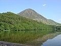
Crummock Water with Grasmoor in the distance
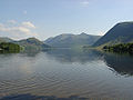
Looking down Crummock towards Buttermere
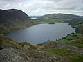
The western end of Crummock Water from Rannerdale Knotts


Outside links
| ("Wikimedia Commons" has material about Crummock Water) |
References
| Major waters of the Lake District | ||
|---|---|---|
| Cumberland: | Bassenthwaite Lake • Burnmoor Tarn • Buttermere • Cogra Moss • Crummock Water • Derwent Water • Devoke Water • Ennerdale Water • Loweswater • Thirlmere • Wast Water | |
| Cumb. / Westm.: | Ullswater | |
| Westmorland: | Grasmere • Haweswater • Rydal Water | |
| Lancs. / Westm.: | Windermere • Elter Water | |
| Lancashire: | Coniston Water • Esthwaite Water • Seathwaite Tarn • Tarn Hows | |