Cava: Difference between revisions
Created page with "{{Infobox island |name=Cava |norse=Kálfey |county=Orkney |picture=On board ferry from Lyness to Houton - View to Calf of Cava & Lighthouse (geograph 3745681).jpg |picture cap..." |
No edit summary |
||
| Line 6: | Line 6: | ||
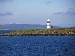
|picture caption=Calf of Cava lighthouse | |picture caption=Calf of Cava lighthouse | ||
|os grid ref=ND326998 | |os grid ref=ND326998 | ||
|latitude= | |latitude=58.88111 | ||
|longitude=-3.16833 | |longitude=-3.16833 | ||
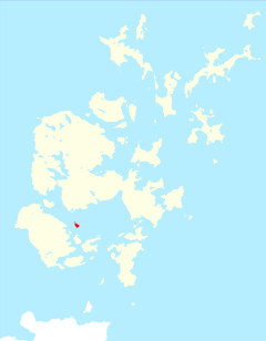
|map=Cava Orkney.svg | |map=Cava Orkney.svg | ||
|area= | |area=264 acres | ||
|area rank=147 | |area rank=147 | ||
|highest height= | |highest height=125 ft | ||
|population=0 | |population=0 | ||
}} | }} | ||
'''Cava''' is an uninhabited island of [[Orkney]]; a peedie place of | '''Cava''' is an uninhabited island of [[Orkney]]; a peedie place of 264 acres rising to a summit of 125 feet above sea level. The literal meaning of the name is ''calf island'', a terminology often used locally to designate a small island near to a larger one. Cava has its own calf too: it includes a small peninsula joined to the main body of the island by a narrow isthmus, which peninsula is called ''Calf of Cava''. | ||
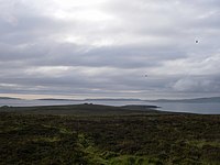
[[File:Cavaorkney.jpg|left|thumb|200px|View from Cava towards Graemsay and Mainland]] | [[File:Cavaorkney.jpg|left|thumb|200px|View from Cava towards Graemsay and Mainland]] | ||
| Line 30: | Line 30: | ||
==References== | ==References== | ||
{{reflist}} | {{reflist}} | ||
{{Orkney}} | {{Orkney}} | ||
Latest revision as of 14:39, 25 January 2019
| Cava | |
 Calf of Cava lighthouse | |
|---|---|
| Location | |
| Location: | 58°52’52"N, 3°10’6"W |
| Grid reference: | ND326998 |
| Area: | 264 acres |
| Highest point: | 125 ft |
| Data | |
| Population: | 0 |
Cava is an uninhabited island of Orkney; a peedie place of 264 acres rising to a summit of 125 feet above sea level. The literal meaning of the name is calf island, a terminology often used locally to designate a small island near to a larger one. Cava has its own calf too: it includes a small peninsula joined to the main body of the island by a narrow isthmus, which peninsula is called Calf of Cava.

The island lies in Scapa Flow just offshore from the much larger island of Hoy. Nearby are the islets of Rysa Little and Fara and the skerry known as Barrel of Butter. To the south of Cava, between Fara and Rysa Little lies Gutter Sound, the scene of the mass-scuttling of the interned German Imperial High Seas Fleet in 1919.
In the eighteenth century a notorious Orkney pirate, John Gow, raided Hall of Clestrain, in Orphir and abducted two servant girls. Reports vary as to their treatment, with one claiming that they were put ashore on Cava "so loaded with presents that they soon afterwards got husbands."[1] Gow's ship Revenge then ran ashore on the Calf of Eday and Gow was captured.[2]
In common with a number of the smaller South Isles of Orkney, Cava lost its resident population during the course of the twentieth century.[3] There is still a habitable building on the island - Cava Lodge. There are no good anchorages in the vicinity.[4]
See also
References
- ↑ "John Gow - The Orkney Pirate" Orkneyjar. Retrieved 11 Mar 2012.
- ↑ Haswell-Smith (2004) p. 388
- ↑ Wenham, Sheena (2003). The Orkney Book by Omand, Donald (ed.). ed. The South Isles. Edinburgh: Birlinn. pp. 208.
- ↑ Haswell-Smith, Hamish (2004). The Scottish Islands. Edinburgh: Canongate. ISBN 1841954543.
| Islands of Orkney |
|---|
|
Inhabited islands: |
