Langbaurgh Wapentake: Difference between revisions
No edit summary |
No edit summary |
||
| (2 intermediate revisions by 2 users not shown) | |||
| Line 27: | Line 27: | ||
*[[Ormesby]] | *[[Ormesby]] | ||
*[[Rudby in Cleveland]] | *[[Rudby in Cleveland]] | ||
*[[Seamer]] | *[[Seamer-in-Cleveland|Seamer]] | ||
*[[Skelton]] | *[[Skelton-in-Cleveland|Skelton]] | ||
*[[Stainton]] | *[[Stainton]] | ||
*[[Stokesley]] | *[[Stokesley]] | ||
| Line 44: | Line 44: | ||
*[http://www.visionofbritain.org.uk/relationships.jsp;jsessionid=64E09EB798DF88EED71B20A1362664D0?u_id=10030663 Langbaurgh Wapentake at Vision of Britain] | *[http://www.visionofbritain.org.uk/relationships.jsp;jsessionid=64E09EB798DF88EED71B20A1362664D0?u_id=10030663 Langbaurgh Wapentake at Vision of Britain] | ||
{{Reflist}} | {{Reflist}} | ||
{{Yorkshire wapentakes}} | {{Yorkshire wapentakes|riding=North}} | ||
Latest revision as of 12:38, 28 February 2021

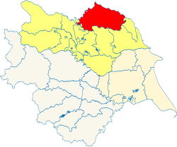
Langbaurgh is a wapentake of the North Riding of Yorkshire, adjacent to the border with County Durham. It covers an area on the northern coast of the county, including Middlesbrough, Easby, Great Ayton, Guisborough, Marske-by-the-Sea, Maltby, Easington and Redcar It has two divisions, the western and eastern. Adjacent wapentakes are Whitby Strand to the south-east; Pickering Lythe, Rydale and Birdforth to the south; and Allertonshire to the west. With a population of 351,572 in 2011, it is the most populous of the wapentakes in the North Riding.
The wapentake took its name from the hamlet of Langbaurgh, near Great Ayton.[1]
It comprises the ancient parishes of:
- Ayton
- Brotton
- Crathorne
- Danby
- Easington
- Great Smeaton (Appleton Wiske and part of Hornby)*
- Guisborough
- Hinderwell
- Ingleby Greenhow
- Kildale
- Kirkby
- Kirklevington
- Loftus
- Lythe
- Marske
- Middlesbrough
- Ormesby
- Rudby in Cleveland
- Seamer
- Skelton
- Stainton
- Stokesley
- Upleathham
- Westerdale
- Whitby (Aislaby township)†
- Whorlton
- Yarm
*: Great Smeaton in East Gilling; Remainder of Hornby in Allertonshire.
†: Remainder in Whitby Strand. Aislaby is sometimes included with that wapentake.
References
- Location map: 54°34’45"N, 1°2’3"W
- Langbaurgh Wapentake at Vision of Britain
- ↑ William Page, ed (1923). Parishes: Great Ayton. Victoria County History. pp. 225-231. http://www.british-history.ac.uk/vch/yorks/north/vol2/pp225-231. Retrieved 8 September 2015.
|
East Riding: Buckrose • Dickering • Harthill • Holderness • Howdenshire • Ouse and Derwent • North Riding: Allertonshire • Birdforth • Bulmer • East Gilling • Hallikeld • Hang East • Hang West • Langbaurgh • Pickering Lythe • Ryedale • West Gilling • Whitby Strand • West Riding: Agbrigg and Morley (Agbrigg, Morley) • Ainsty • Barkston Ash • Claro • Osgoldcross • Skyrack • Staincliffe and Ewcross (Staincliffe, Ewcross) • Staincross • Strafforth and Tickhill |
