Cogra Moss: Difference between revisions
Jump to navigation
Jump to search
Created page with 'right|thumb|300px|Congra Moss {{#vardefine:shire|Cumberland}} '''Cogra Moss''' is a shallow reservoir to the east of t…' |
mNo edit summary |
||
| Line 8: | Line 8: | ||
==Outside links== | ==Outside links== | ||
[[File:Cogra Moss - geograph.org.uk - 1204138.jpg|left|220px|Cogra Moss]] | |||
{{commons}} | |||
==References== | ==References== | ||
{{reflist}} | {{reflist}} | ||
Latest revision as of 22:49, 2 April 2013

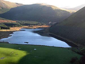
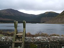
Cogra Moss is a shallow reservoir to the east of the village of Lamplugh in Cumberland, on the western edge of the Lake District. It was created by the damming of Rakegill Beck in about 1880, though its function as a water supply ceased in 1975.
The water is surrounded by forestry plantations on three sides, which climb up the flanking hills; Lamplugh Fell to the north and east and Knock Murton to the south. Thi is indeed the edge of the fells, for beyond these friendly hills the wild fells begin in earnest; Lamplugh is but the lower slope of Loweswater Fell.
The lake shore is popular with walkers and anglers.
Outside links

| ("Wikimedia Commons" has material about Cogra Moss) |
References
54°33′48″N 3°24′04″W / 54.56333°N 3.40111°WCoordinates: 54°33′48″N 3°24′04″W / 54.56333°N 3.40111°W
| Major waters of the Lake District | ||
|---|---|---|
| Cumberland: | Bassenthwaite Lake • Burnmoor Tarn • Buttermere • Cogra Moss • Crummock Water • Derwent Water • Devoke Water • Ennerdale Water • Loweswater • Thirlmere • Wast Water | |
| Cumb. / Westm.: | Ullswater | |
| Westmorland: | Grasmere • Haweswater • Rydal Water | |
| Lancs. / Westm.: | Windermere • Elter Water | |
| Lancashire: | Coniston Water • Esthwaite Water • Seathwaite Tarn • Tarn Hows | |
