Harthill Wapentake: Difference between revisions
mNo edit summary |
|||
| Line 62: | Line 62: | ||
*[[Walkington]] (part)<sup>‡</sup> | *[[Walkington]] (part)<sup>‡</sup> | ||
*[[Warter]] | *[[Warter]] | ||
*[[Watton]] | *[[Watton, Yorkshire|Watton]] | ||
*[[Wilberfoss]] | *[[Wilberfoss]] | ||
*[[Wressle]] | *[[Wressle]] | ||
Latest revision as of 14:55, 4 July 2024

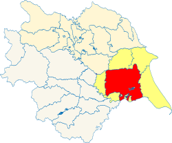
Harthill is a wapentake of the East Riding of Yorkshire consisting of the central part of the riding. Because of its large area it is sub-divided into four divisions—Bainton Beacon Division, Holme Beacon Division, Hunsley Beacon Division and Wilton Beacon Division. As a result of of its central position, Harthill has borders with every other wapentake in the East Riding: Buckrose and Dickering to the north, Holderness to the east, Howdenshire to the south-west and Ouse and Derwent to the west. Including the western parts of the city of Hull, it had a population of 313,729 in 2011, making it the most populous wapentake in the East Riding.
It comprises the ancient parishes of:
- Allerthorpe
- Aughton
- Bainton
- Barmby Moor
- Beverley St John, St Nicholas & St Martin
- Bishop Burton
- Bishop Wilton
- Brantingham (Thorpe Brantingham township)*
- Bubwith
- Burnby
- Catton (except Kexby and Stamford Bridge West with Scoreby)†
- Cherry Burton
- Cottingham
- Ellerton Priory
- Elloughton
- Everingham
- Fangfoss
- Full Sutton
- Goodmanham
- Great Driffield
- Great Givendale
- Harswell
- Hayton
- Hessle
- Holme upon Spalding Moor
- Hotham
- Huggate
- Hutton Cranswick
- Kilnwick
- Kilnwick Percy
- Kingston upon Hull Holy Trinity
- Kirkburn
- Kirk Ella
- Leconfield
- Lockington
- Londesborough
- Market Weighton
- Millington
- New Village (ex. par.)
- North Cave
- North Dalton
- North Ferriby
- North Newbald
- Nunburnholme
- Pocklington
- Rowley
- Sancton
- Scorborough
- Sculcoates
- Seaton Ross
- Skerne
- Skidby
- South Cave
- Sutton upon Derwent
- Thornton
- Walkington (part)‡
- Warter
- Watton
- Wilberfoss
- Wressle
*: Remainder in Howdenshire. Additionally, some areas are said to be common to Harthill and Howdenshire.
†: In Ouse and Derwent wapentake.
‡: Partly in Howdenshire.
References
- Location map: 53°49’44"N, -0°39’7"W
- "Relationships / unit history of Harthill". A Vision of Britain Through Time. Great Britain Historical GIS Project. http://www.visionofbritain.org.uk/relationships.jsp?u_id=10167735. Retrieved 2009-07-23.
|
East Riding: Buckrose • Dickering • Harthill • Holderness • Howdenshire • Ouse and Derwent • North Riding: Allertonshire • Birdforth • Bulmer • East Gilling • Hallikeld • Hang East • Hang West • Langbaurgh • Pickering Lythe • Ryedale • West Gilling • Whitby Strand • West Riding: Agbrigg and Morley (Agbrigg, Morley) • Ainsty • Barkston Ash • Claro • Osgoldcross • Skyrack • Staincliffe and Ewcross (Staincliffe, Ewcross) • Staincross • Strafforth and Tickhill |
